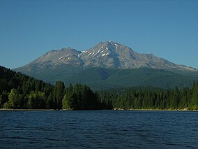
The Mount Shasta Wilderness is a 38,200-acre (155 km2) federally designated wilderness area located 5 miles (8.0 km) east of Mount Shasta City in northern California. The US Congress passed the 1984 California Wilderness Act that set aside the Mount Shasta Wilderness. The US Forest Service is the managing agency as the wilderness is within the Shasta-Trinity National Forest. The area is named for and is dominated by the Mount Shasta volcano which reaches a traditionally quoted height of 14,162 feet (4,317 m) above sea level, but official sources give values ranging from 14,104 feet (4,299 m) from one USGS project,[1] to 14,179 feet (4,322 m) via the NOAA.[2] Mount Shasta is one of only two peaks in the state over 14,000 feet (4,300 m) outside the Sierra Nevada Mountain Range. The other summit is White Mountain Peak in the Great Basin of east-central California.[3]
The Wintun Glacier is located on Mount Shasta and is the lowest-elevation glacier in the state, lying at 9,100 feet (2,800 m) elevation and extending to the summit.[4]
The smaller volcanic cone of Shastina (12,270 ft)[5] lies one mile (1.6 km) west of Mount Shasta and was formed after the ice-age glaciers melted.
The wilderness protects both pristine forests and areas that were intensively logged and roaded
in the past. Although less than half of the mountain remains roadless, Mount Shasta Wilderness is still the premier destination for a variety of activities from mountaineering, day-hiking, and backpacking to cross-country skiing, snowshoeing and ski mountaineering. It is valued for the many scenic, geologic and recreational attributes including glaciers, lava flows, hot springs, waterfalls and forests of Shasta red fir, sugar pine and other conifers.
^United States Geological Survey (USGS) Geographical Names Information System(GNIS)
^"Datasheet for benchmark MX1016". National Geodetic Survey. This seems to be the latest and most accurate measurement from the U.S. Geodetic Survey.
^Atkinson, Ron p.224
^Atkinson, Ron p.227
^USGS-GNIS
and 26 Related for: Mount Shasta Wilderness information
The MountShastaWilderness is a 38,200-acre (155 km2) federally designated wilderness area located 5 miles (8.0 km) east of MountShasta City in northern...
MountShasta (/ˈʃæstə/ SHASS-tə; Shasta: Waka-nunee-Tuki-wuki; Karuk: Úytaahkoo) is a potentially active volcano at the southern end of the Cascade Range...
Volcanic National Park, Caribou Wilderness, Thousand Lakes Wilderness, and climbing MountShasta. The civic "capital" of the Shasta Cascade area is Redding;...
County and Shasta County, 40 miles (64 km) north of Redding and south of MountShasta City. The US Congress passed the California Wilderness Act in 1984...
California) MountShastaWilderness, also in California at 41°25′08″N 122°12′26″W / 41.41889°N 122.20722°W / 41.41889; -122.20722 (MountShastaWilderness) This...
MountShasta, and south-southeast of Crater Lake. It was named around 1838 after John McLoughlin, a Chief Factor for the Hudson's Bay Company. Mount McLouglin's...
on MountShasta owned by the nonprofit Sierra Club Foundation. It is a 720-acre (2.9 km2) enclave within the MountShastaWilderness of the Shasta-Trinity...
Wilderness Shasta-Trinity National Forest Wilderness Areas MountShastaWilderness Lassen National Forest Wilderness Areas Caribou Wilderness Ishi Wilderness Thousand...
engineering feats like the California and Los Angeles Aqueducts; the Oroville and Shasta Dams; and the Bay and Golden Gate Bridges were built. The state government...
The Ishi Wilderness is a 41,339 acre (167 km2) wilderness area located on the Lassen National Forest in the Shasta Cascade foothills of northern California...
Manly Peak Wilderness is a Bureau of Land Management wilderness area in Inyo County, California. The area was established in 1994 through the California...
The Desolation Wilderness is a 63,960-acre (258.8 km2) federally protected wilderness area in the Eldorado National Forest and Lake Tahoe Basin Management...
park includes 429,690 acres (671.4 sq mi; 1,738.9 km2) of designated wilderness. Straddling San Bernardino and Riverside Counties, the park includes parts...
and biological diversity. Almost 95 percent of the park is designated wilderness. Yosemite is one of the largest and least fragmented habitat blocks in...
MountShasta Ski Park is a ski resort located in northern California which has winter and summer operations. Winter operations include skiing & snowboarding...
the National Park Service and the majority of the park is protected as wilderness. The national park is divided by the rock formations into East and West...
on both sides of Interstate 5 at them, and by Castle Crags Wilderness Area of the Shasta-Trinity National Forest. Although the Northern Coast Ranges...
Hoover Wilderness (mostly in Toiyabe NF) Inyo Mountains Wilderness John Muir Wilderness (mostly in Sierra NF) Owens River Headwaters Wilderness South Sierra...
line. The wilderness area is managed by the Bureau of Land Management. "Picacho Peak Wilderness". wilderness.net. "Picacho Peak Wilderness". blm.gov....
rhododendron, and wildlife reserves; state beaches, recreation areas, wilderness areas, and reservoirs; state historic parks, historic homes, Spanish era...
Canyon Wilderness". wilderness.net. Archived from the original on December 5, 2019. Retrieved August 31, 2019. "John Krebs Wilderness". wilderness.net....
is Snow Creek Village and the Morongo Indian Reservation. Mount San Jacinto State Wilderness is carved out of the southern portion. The community of Idyllwild...
Lake to MountShasta. They were the first recorded party to travel much of the general route of what is now the Pacific Crest Trail. Wilderness Act List...
golf, croquet and tennis were all available, while Hearst would lead mounted parties for picnics on the estate. The only absolute deadline was for cocktails...
Mount Diablo is a mountain of the Diablo Range, in Contra Costa County of the eastern San Francisco Bay Area in Northern California. It is south of Clayton...
Garcia Wilderness is a 14,100-acre (57 km2) wilderness area within the Los Padres National Forest in San Luis Obispo County, California. The wilderness was...
 Global Information