Mount Sequoyah is a mountain in the Great Smoky Mountains, located in
the Southeastern United States. It has an elevation of 6,003 feet (1,830 meters) above sea level.[1] While
the Appalachian Trail crosses its summit, Sequoyah is an 11.5-mile (18.5 km) hike from
the nearest parking lot, making it one of the most remote places in the Great Smoky Mountains National Park.
The Tennessee-North Carolina border traverses Mount Sequoyah, with Sevier County to the north and Swain County to the south. The mountain consists of four small peaks, with the easternmost being the true (highest) summit. Sequoyah rises approximately 1,500 feet (460 m) above its southern base along Left Fork Creek [2] and approximately 3,500 feet (1,100 m) above its northern base along the Little Pigeon River.[3] Part of the headwaters of the Little Pigeon accumulate along Sequoyah's northern slope.[4]
Mount Sequoyah is named after the inventor of the Cherokee alphabet.[5] While it's doubtful that Sequoyah ever visited the mountain, numerous Cherokee villages dotted the base of the southeastern Smokies when European settlers arrived in the early 18th century.[6] Arnold Guyot crossed Mount Sequoyah on his survey of the Smokies crest in the late 1850s. Guyot referred to the mountain as "The Three Brothers", and measured its elevation at 5,945 feet (1,812 m).[7] The mountain rarely saw a human presence until a segment of the Appalachian Trail was constructed across its summit in 1935.[8]
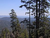
The view looking south from the Appalachian Trail, near the summit of Sequoyah
The summit of Mount Sequoyah is among the most distant summits traversed by a trail in the Great Smokies. Following the Appalachian Trail from Newfound Gap, Mount Sequoyah is 13.1 miles (21.1 km) to the east. From the Cosby Campground, Sequoyah can be reached by following the Snake Den Ridge Trail 5.3 miles (8.5 km) to its junction with the Appalachian Trail, and then following the latter 3.7 miles (6.0 km) to Tricorner Knob, crossing Old Black and Mount Guyot along the way. From Tricorner, Mount Sequoyah is 2.5 miles (4.0 km) to the southwest, just beyond Mount Chapman. The Hughes Ridge Trail, which connects the Appalachian Trail and the Benton MacKaye Trail, terminates just over two miles (3.2 km) southwest of Sequoyah.
35°40′37″N 83°16′55″W / 35.67698°N 83.28203°W / 35.67698; -83.28203 MountSequoyah is a mountain in the Great Smoky Mountains, located in the Southeastern...
question marks, boxes, or other symbols instead of Cherokee syllabics. Sequoyah (Cherokee: ᏍᏏᏉᏯ, Ssiquoya, or ᏎᏉᏯ, Se-quo-ya; IPA: [seɡʷoja], c. 1770 –...
Look up Sequoia, sequoia, or Sequoyah in Wiktionary, the free dictionary. Sequoia, Sequoya or Sequoyah refers to a type of tree in the cypress family...
The MountSequoyah Cottages are a pair of historic summer cabins at 808 and 810 East Skyline Drive in Fayetteville, Arkansas. They were built in the 1920s...
Rogers and Springdale. Filming took place mainly in Fayetteville, from MountSequoyah to homes, apartments and restaurants around the city. Filming on location...
Silers Bald, Mount Collins, Newfound Gap, Mount Kephart, Charlies Bunion, MountSequoyah, Mount Chapman, Mount Guyot, Old Black, and Mount Cammerer. A...
Knob Luftee Knob Marks Knob Big Cataloochee Mount Hardison Mount Yonaguska Mount Ambler Mount Hardy Mount Mitchell State Park Great Smoky Mountains National...
Tennessee/North Carolina Mount Cammerer Old Black Mount Guyot Mount Chapman MountSequoyah Charlies Bunion Mount Kephart Mount Le Conte Clingmans Dome...
Lookout Mountain Little Mountain Mount Chapman Mount Collins Mount Evil Mount Guyot Mount Kephart Mount Le Conte MountSequoyah Pilot Knob Roan High Knob Short...
Gregory Bald Marks Knob Mount Cammerer Mount Chapman Mount Collins Mount Guyot Mount Hardison Mount Kephart MountSequoyahMount Sterling Old Black Shuckstack...
Mountain Gregory Bald Mount Cammerer Mount Chapman Mount Collins Mount Guyot Mount Kephart Mount Le Conte Mount Mingus MountSequoyah Old Black Silers Bald...
Gregory Bald Marks Knob Mount Cammerer Mount Chapman Mount Collins Mount Guyot Mount Hardison Mount Kephart MountSequoyahMount Sterling Old Black Shuckstack...
location was along Assembly Road and Skyline Drive where it circled around MountSequoyah and returned to its single terminus of Highway 45. This segment was...
Fayetteville 0.00 0.00 College Avenue Former US 71B Assembly Road - MountSequoyah Assembly Former AR 180 east 2.88 4.63 AR 265 (Crossover Road) to AR 16 –...
The 1st Cherokee Mounted Rifles (also known as the 1st Arkansas Cherokee Mounted Rifles and the "Cherokee Braves") was a cavalry formation of the Confederate...
19th century by the didanvwisgi (ᏗᏓᏅᏫᏍᎩ), Cherokee medicine men, after Sequoyah's creation of the Cherokee syllabary in the 1820s. Initially only the didanvwisgi...
potential hypothesis for the species name, is in honor of the Cherokee Chief Sequoyah, however there are no surviving records of why the species was named as...
prominent sequoias. Chief Sequoyah: Just uphill from the President tree is the massive and very impressive Chief Sequoyah. This tree is one of the most...
Cherokee, Craig, Delaware, Mayes, McIntosh, Muskogee, Nowata, Ottawa, Rogers, Sequoyah, Tulsa, Wagoner, and Washington counties. After Cherokee removal on the...
(not to be confused with the Sequoyah Council located in Tennessee and Virginia) The Sequoia Council serves Fresno, Madera, Kings and Tulare Counties in...
Current Anthropology 62, no. 6 (2021):669-691. Summitt, April R. (2012). Sequoyah and the Invention of the Cherokee Alphabet. ABC-CLIO. p. 83. ISBN 978-0-313-39177-4...
status) to the United States Congress. In 1905 he was President of the Sequoyah Constitutional Convention, an effort by Native American tribes to acquire...
smaller lakes include Lake Sequoyah, a small recreational fishing lake east of Fayetteville, Arkansas, formed in 1961; Sequoyah is the uppermost impoundment...
1954- English singer-songwriter and musician (The Damned) Johnny Sequoyah John Sequoyah Friedenberg 2002- American actress MC Serch Michael Berrin 1967-...
 Global Information