Mount Roland is a locality, a mountain, and a conservation area in the north west coast region of Tasmania, Australia.[3]
The mountain is near the town of Sheffield. The peak rises to 1,234 metres (4,049 ft) above sea level[1] and there are a number of well-marked bushwalks suitable for a day of pleasant exercise. There are long established walking tracks from both Claude Road and Gowrie Park to the summit.[4][5][6][7]
A Mount Roland cable car has been proposed for the mountain on several occasions.[8] The local community remains divided over the suitability or desirability of a cable car.[9]
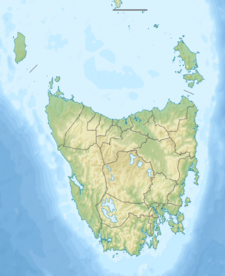
The locality of Mount Roland is a rural locality in the local government areas of Meander Valley and Kentish in the Launceston and North and north-west regions of Tasmania. The locality is about 75 kilometres (47 mi) west of the town of Westbury. The 2016 census has a population of nil for the state suburb of Mount Roland.[10]
Mount Roland is a confirmed locality.[11]
The Mersey River forms part of the southern boundary. The Mount Roland Conservation Area occupies a small area in the north of the locality.[12]
Route C136 (Claude Road) runs through the north-east corner of the locality. Route C138 (Olivers Road) enters from the north-west and runs south until it exits.[11][13]
There was a death near the summit in 2015; a senior South Australian health official is alleged to have murdered his wife. The official later killed himself while he was in the Risdon jail.[14]
^ abc"Mount Roland, Australia". Peakbagger.com. Retrieved 7 June 2015.
^"Mount Roland (TAS)". Gazetteer of Australia online. Geoscience Australia, Australian Government.
^University of Tasmania. Institute for Regional Development; Mount Roland Steering Committee (Tas.) (2011), Mount Roland developing a destination, University of Tasmania, archived from the original on 1 May 2012, retrieved 12 July 2012
^"ON MOUNT ROLAND". The Examiner (DAILY ed.). Launceston, Tasmania. 11 January 1910. p. 4. Retrieved 12 July 2012 – via National Library of Australia.
^Tasmania. Dept. of Parks, Wildlife and Heritage (1990), Mount Roland day walk map, Tasmap, retrieved 12 July 2012
^Mount Roland day walk map, Tasmap, 1986, retrieved 12 July 2012
^Mount Roland bushwalk, Hiking the World (published 2020), 7 March 2018, retrieved 17 December 2020
^"Cable car tourism push for Sheffield's Mt Roland". The Mercury. 27 April 2014. Archived from the original on 23 January 2015. Retrieved 23 January 2015.
^"Archived copy" (PDF). Archived (PDF) from the original on 23 January 2015. Retrieved 20 April 2015.{{cite web}}: CS1 maint: archived copy as title (link)
^"2016 Census Quick Stats Mount Roland (Tas.)". quickstats.censusdata.abs.gov.au. Australian Bureau of Statistics. 23 October 2017. Retrieved 13 September 2020.
^ ab"Placenames Tasmania – Mount Roland". Placenames Tasmania. Select “Search”, enter "38115E", click “Search”, select row, map is displayed, click “Details”. Retrieved 13 September 2020.
^Google (13 September 2020). "Mount Roland, Tasmania" (Map). Google Maps. Google. Retrieved 13 September 2020.
^"Tasmanian Road Route Codes" (PDF). Department of Primary Industries, Parks, Water & Environment. May 2017. Archived from the original (PDF) on 1 August 2017. Retrieved 13 September 2020.
^"Alleged SA wife-killer takes own life". adelaidenow. 29 June 2015. Retrieved 12 June 2023.
and 23 Related for: Mount Roland Conservation Area information
MountRoland is a locality, a mountain, and a conservationarea in the north west coast region of Tasmania, Australia. The mountain is near the town of...
Leven Canyon Lukes Knob Meredith Range Mount Dundas Mount Farrell Mount Heemskirk Mount Murchison MountRoland Parting Creek Renison Bell St Pauls Teepookana...
Roland Palmedo (April 5, 1895 – March 15, 1977) was a pioneering developer of recreational skiing in the United States. He founded the Mount Mansfield...
construction by both the Works Progress Administration and the Civilian Conservation Corps. The northern portion of the park was transferred to the National...
federal government in the 1930s, one of the many projects of the Civilian Conservation Corps during the Great Depression. The road was the proposal of U.S....
Management of the Angkor Area. Archived from the original on 3 March 2001. "Conservation, Risk Map". German Apsara Conservation Project. p. 2. Retrieved...
with a surface area of 700 km2 (270 sq mi). Angel Falls, the highest waterfall in the world, drops from a cleft in the summit. Mount Roraima, also known...
Grevillea batrachioides, commonly known as Mount Lesueur grevillea, is a shrub which is endemic to a small area along the west coast in the Mid West region...
commonly known as the Mount Canobolas candlebark or silver-leaf candlebark, is a species of tree that is endemic to a small area of New South Wales in...
paper to the Naturalists, she spoke about botany and the geology of MountRoland, at the foothills of Cradle Mountain. Talking about the vegetation experienced...
vulnerable. "Homoranthus montanus". Australian Plant Census. "Approved conservation advice for Homoranthus montanus" (PDF). Australian Government Department...
"Section 7: Roland C. Nickerson State Park" (PDF). Resource Management Plan: Nickerson (Cape & Islands) Complex. Department of Conservation and Recreation...
is a Latin word meaning "full of lumps". This zieria occurs in the Mount Gulaga area, growing in exposed, rocky outcrops on the edge of rainforest. This...
established on Mount Gale includes a protected area, uniting privately owned lands for conservation and hiking. In spite of these conservation efforts, a...
cat's face orchid grows in sandy soil on the edge of winter-wet areas between York and Mount Barker in the Swan Coastal Plain biogeographic region. It is...
Jordanian Department of Antiquities, led by Gerald Lankester Harding and Roland de Vaux.: 9 The Cave 1 site yielded discoveries of additional Dead Sea...
Federation's Roland Michener Conservation Award which recognizes individuals who have shown a commitment to "promote, enhance, and further the conservation of Canada's...
a wildlife management area, in which hunting and fishing activities are managed by the Florida Fish and Wildlife Conservation Commission. A permit is...
prominence is 9,330 m (30,610 ft). This dry prominence is greater than Mount Everest's height above sea level of 8,848.86 m (29,032 ft), and some authorities...
government authority. It was built on the site of the demolished Friars Mount rookery in the Old Nichol, with works begun by the Metropolitan Board of...
National Park and Mount Barker area in the Esperance Plains and Jarrah Forest biogeographic regions where it grows in low-lying areas that are wet in winter...
 Global Information