 Global Information
Mount Randy Morgenson information
| Mount Randy Morgenson | |
|---|---|
| Mount Morgenson | |
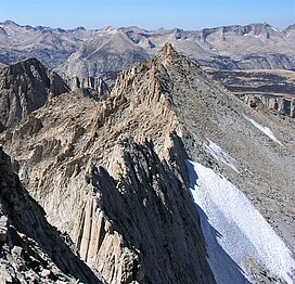 As seen from Mount Russell | |
| Highest point | |
| Elevation | 13,927 ft (4,245 m)[1] |
| Prominence | 279 ft (85 m)[1] |
| Parent peak | Mount Russell (14,088 ft)[1] |
| Isolation | 0.51 mi (0.82 km)[1] |
| Coordinates | 36°35′30″N 118°17′59″W / 36.591603°N 118.299852°W[1] |
| Naming | |
| Etymology | Randy Morgenson (park ranger) |
| Geography | |
 Mount Randy Morgenson  Mount Randy Morgenson | |
| Location | Sequoia National Park Tulare County California, U.S. |
| Parent range | Sierra Nevada |
| Topo map | USGS Mount Whitney |
| Geology | |
| Age of rock | Cretaceous |
| Mountain type | Fault block |
| Type of rock | granite |
| Climbing | |
| First ascent | 1926 Norman Clyde |
| Easiest route | class 2[2] |
Mount Randy Morgenson is a 13,927-foot-elevation (4,245-meter) mountain summit located along the crest of the Sierra Nevada mountain range in Tulare County, California. It is situated in Sequoia National Park, one mile north-northwest of Mount Whitney, 0.85 mile east of Mount Hale, and one-half mile west of Mount Russell, the nearest higher neighbor. The John Muir Trail traverses to the south of the mountain, providing an approach option. Mt. Morgenson ranks as the 20th-highest summit in California.[2] Topographic relief is significant as the northwest aspect rises 2,200 feet (670 meters) above Wales Lake in less than one mile.
- ^ a b c d e "Mount Morgenson, California". Peakbagger.com. Retrieved 2021-06-13.
- ^ a b "Mount Randy Morgenson - 13,927' CA". listsofjohn.com. Retrieved 2021-06-13.