Chittenden County-Lamoille County border, Vermont, U.S.
Parent range
Green Mountains
Topo map
USGS Mount Mansfield
Climbing
Easiest route
Hike
U.S. National Natural Landmark
Designated
1980
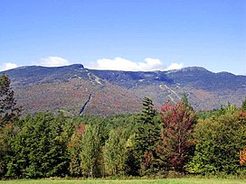
Mount Mansfield is the highest mountain in Vermont with a summit that peaks at 4,393 feet (1,339 m) above sea level.[3] The summit is located within the town of Underhill in Chittenden County; the ridgeline, including some secondary peaks, extends into the town of Stowe in Lamoille County, and the mountain's flanks also reach into the town of Cambridge.[4]
When viewed from the east or west, this mountain has the appearance of a (quite elongated) human profile, with distinct forehead, nose, lips, chin, and Adam's apple. These features are most distinct when viewed from the east; unlike most human faces, the chin is the highest point.[5]
Mount Mansfield is one of three spots in Vermont where true alpine tundra survives from the Ice Ages. A few acres exist on Camel's Hump and Mount Abraham nearby and to the south, but Mount Mansfield's summit still holds about 200 acres (81 ha). In 1980, the Mount Mansfield Natural Area was designated as a National Natural Landmark by the National Park Service.[6]
Located in Mount Mansfield State Forest, the mountain is used for various recreational and commercial purposes. "The Nose" is home to transmitter towers for a number of regional radio and TV stations.[7][8] There are many hiking trails, including the Long Trail, which traverses the main ridgeline. In addition, the east flank of the mountain is used by the Stowe Mountain Resort for winter skiing. A popular tourist activity is to take the 4.5-mile (7.2 km) toll road (a steep, mostly unpaved road with several hairpin turns) from the Stowe Base Lodge to "The Nose" and then hike along the ridge to "The Chin."
^ ab"Mt Mansfield Highest Point". NGS Data Sheet. National Geodetic Survey, National Oceanic and Atmospheric Administration, United States Department of Commerce. Retrieved 2008-12-11.
MountMansfield is the highest mountain in Vermont with a summit that peaks at 4,393 feet (1,339 m) above sea level. The summit is located within the...
view from Jericho Top of MountMansfield facing west Eastward view of "The Chin" View from the northeast Top of MountMansfield facing south Top of Killington...
MountMansfield Union High School (MMU) is a high school located near the center of Jericho, Vermont. It is accredited by the New England Association...
comprising two separate mountains: MountMansfield and Spruce Peak. The lift-served vertical drop of MountMansfield is 2,360 feet (719 m), the fifth largest...
include: MountMansfield, 4,395 feet (1,340 m), the highest point in Vermont Killington Peak, 4,241 feet (1,293 m) Camel's Hump, 4,084 feet (1,245 m) Mount Ellen...
Jayne Mansfield (born Vera Jayne Palmer; April 19, 1933 – June 29, 1967) was an American actress and Playboy Playmate. A sex symbol of the 1950s and early...
Mountain, Stratton Mountain, Killington Peak, Mount Abraham, Mount Ellen, Camel's Hump, MountMansfield, and Jay Peak. The Long Trail is maintained primarily...
The MountMansfield Electric Railroad was an intrastate railroad in central Vermont. It ran from Waterbury to Stowe, a distance of approximately 12 miles...
separates MountMansfield, the highest peak of the Green Mountains, from Spruce Peak and the Sterling Range. Most of the notch is in MountMansfield State...
Marymount University, in Arlington, Virginia MountMansfield Union High School, in Jericho, Vermont Mount Meru University, in Tanzania Mountains of the...
these, MountMansfield (1858) was his primary work, exhibited at the National Academy of Design in 1859. Thompson also exhibited a painting of Mount Mansfield...
including MountMansfield, the highest mountain in the state; Killington Peak, the second-highest; Camel's Hump, the state's third-highest; and Mount Abraham...
Champlain Waldorf High School, Shelburne Milton Senior High School, Milton MountMansfield Union High School, Jericho Rice Memorial High School, South Burlington...
Mansfield /ˈmænsfiːld/ is a market town and the administrative centre of the Mansfield District in Nottinghamshire, England. It is the largest town in...
August 2021, had a population of 10,178. It includes the towns of Mansfield, Maindample, Mount Buller, Bonnie Doon, Jamieson, Kevington, Merrijig, Tolmie and...
MountMansfield Modified Union School District (MMUUSD), formerly the MountMansfield Union School District #17, is a school district headquartered in...
MountMansfield State Forest covers 44,444 acres (179.86 km2) in seven towns in Chittenden, Lamoille and Washington counties in Vermont. The towns are...
Representatives in 2022. From 2020 to 2022 she served as chair of the MountMansfield Unified Union School District board. Novak, Alison. "As Legislators...
Mount Ascutney is a mountain in the U.S. state of Vermont. At 3,144 feet (958 m), it is the highest peak in Windsor County. Mount Ascutney is a monadnock...
technically in three countries. The highest peak of the mountain range is Mount Mitchell in North Carolina at 6,684 feet (2,037 m), which is also the highest...
 Global Information