Global Information Lookup Global Information

Motu Matakohe information


Motu Matakohe
Matakohe (Māori)
Nickname: Limestone Island
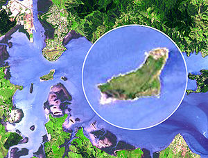
The island from above
Map
Geography
LocationWhangārei Harbour, Pacific Ocean
Coordinates35°47′3″S 174°21′34″E / 35.78417°S 174.35944°E / -35.78417; 174.35944
Area0.37 km2 (0.14 sq mi)
Administration
New Zealand
NorthlandMotu Matakohe New Zealand
Demographics
Population1 (island ranger)
Pop. density0/km2 (0/sq mi)
View of Whangārei Harbour

Motu Matakohe, also known as Matakohe or Limestone Island, is a 37 hectares (91 acres) island in the upper reaches of Whangārei Harbour, just off Onerahi, a seaside suburb of the city of Whangārei, Northland, New Zealand. Used for farming and industry for many years, the island is an example of ecological island restoration by a volunteer community group.

and 5 Related for: Motu Matakohe information

Request time (Page generated in 1.4186 seconds.)

Motu Matakohe

Last Update:

Motu Matakohe, also known as Matakohe or Limestone Island, is a 37 hectares (91 acres) island in the upper reaches of Whangārei Harbour, just off Onerahi...

Word Count : 782

List of islands of New Zealand

Last Update:

Islands Motukiore Island, Parua Bay Motukōkako Island / Piercy Island Motu Matakohe / Limestone Island Motunau Island Motunau / Plate Island Motuora Motuoroi...

Word Count : 1785

Onerahi

Last Update:

Whangarei via the Onerahi Causeway. Close to the suburb in the harbour is Motu Matakohe or Limestone Island, now being managed to restore its ecosystems. Public...

Word Count : 873

List of rivers of New Zealand

Last Update:

Mata River Matahaka River Mataikona River Matakana River Matakitaki River Matakohe River Mataroa River Mataura River Mathias River Matiri River Matukituki...

Word Count : 2843

Scenic reserves of New Zealand

Last Update:

Reserve Marua Valley Scenic Reserve Mata Farm Settlement Scenic Reserve Matakohe River Scenic Reserve Mataraua Valley Scenic Reserve Matarau Island Scenic...

Word Count : 2028

PDF Search Engine © AllGlobal.net