83,700 ML (1.84×10¹⁰ imp gal; 2.21×10¹⁰ US gal)[2][3]
Catchment area
228 km2 (88 sq mi)[1][2]
Surface area
827 ha (2,040 acres)[2][3]
Normal elevation
154.91 m (508.2 ft) AHD
Website www.seqwater.com.au
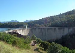
The Moogerah Dam is a mass concrete double curvature arch dam with an un-gated spillway across Reynolds Creek in South East Queensland, Australia, now within the locality of Moogerah in the Scenic Rim Region. The main purposes of the dam are for irrigation in the Reynolds Creek district and for supply of potable water to Warrill Creek and farmers in the Warrill Valley.[1][3][4] The impounded reservoir is called Lake Moogerah.[5]
The name Moogerah is derived from an Aboriginal word meaning thunder.[5]
^ abcdefg"Register of Large Dams in Australia". Dams information. Australian National Committee on Large Dams. 2010. Archived from the original (Excel (requires download)) on 12 December 2013. Retrieved 4 July 2014.
^ abcd"Moogerah Dam". Water supply: Dams and weirs. Seqwater. 2014. Retrieved 4 July 2014.
^ abcCite error: The named reference qlddams was invoked but never defined (see the help page).
^"Lake Moogerah" (PDF). Seqwater. p. 2. Retrieved 22 July 2023.
^ ab"Lake Moogerah – reservoir in the Scenic Rim Region (entry 22582)". Queensland Place Names. Queensland Government. Retrieved 22 July 2023.
The MoogerahDam is a mass concrete double curvature arch dam with an un-gated spillway across Reynolds Creek in South East Queensland, Australia, now...
protected areas which surround volcanic peaks and rocky cliffs near MoogerahDam. Because the peaks are relatively inaccessible the natural vegetation...
Cunninghams Gap, Mount Mitchell and parts of the Main Range National Park. The Moogerah Peaks are a series of mountain peaks in the southeast of the catchment...
(primary coordinates) GPX (secondary coordinates) Dams and reservoirs in Australia is a link page for any dam or reservoir in Australia. There are three key...
Rathdowney, Beechmont and Harrisville. The peak at Mount French, part of Moogerah Peaks National Park is noted for its traditional rock climbing and does...
doubled, irrigated land doubled, and a number of projects such as the MoogerahDam were undertaken. Mining boomed – total mining output almost trebled,...
The Maroon Moogerah Fish Management Association is the local fish stocking group. A stocked impoundment permit is required to fish in the dam. Queensland...
walls of Cressbrook, Hinze, Maroon, Moogerah, North Pine, Somerset, and Wivenhoe Dams and lakes Dyer (Bill Gunn dam) and Clarendon- the fish is a no-take...
Atherton Tableland. It then passes north of Lake Barrine and south of Tinaroo Dam before reaching Yungaburra, where it passes the exit to Malanda-Lake Barrine...
through Toowoomba. Coolmunda Dam, Leslie Dam, Cooby Dam, Perseverance Dam, Cressbrook Dam, Storm King Dam and the Glenlyon Dam are some of the major water...
2022. A project to develop supporting road infrastructure for the Emu Swamp Dam, adjacent to the New England Highway at Stanthorpe, at a cost of $6.3 million...
 Global Information