-
 Repair of Route 2 after a 6-mile washout along the Cold River caused by Hurricane Irene.
 -
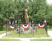 "The Elk On The Trail" statue, Whitcomb's Summit
 -
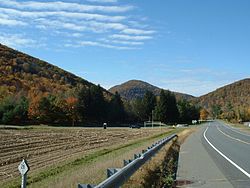
 The Western Summit near the end of the Mohawk Trail, looking towards North Adams and the Taconic Range
 -
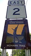 Massachusetts Route 2 at the beginning of the Mohawk Trail, Williamstown
 -
 Tichnor Bros. large-letter postcard c. 1940
 Global Information
Mohawk Trail information
Mohawk Trail | |
U.S. National Register of Historic Places | |
U.S. National Historic Site | |
 The Mohawk Trail, with Todd Mountain in the background | |
  | |
| Nearest city | Greenfield and North Adams, Massachusetts |
|---|---|
| Coordinates | 42°38′27″N 72°57′13″W / 42.64083°N 72.95361°W |
| Area | 2,275 acres (921 ha) |
| NRHP reference No. | 73000283 [1] |
| Added to NRHP | April 03, 1973 |
The Mohawk Trail began as a Native American trade route which connected Atlantic tribes with tribes in Upstate New York and beyond. It followed the Millers River, Deerfield River and crossed the Hoosac Range, in the area that is now northwestern Massachusetts.
Today the Mohawk Trail is a part of Routes 2 and 2A. It follows much of the original Indian trail, from Westminster, Massachusetts to Williamstown, Massachusetts, for about 69 miles (111 km), and passes through the communities of Orange, Erving, Gill, Greenfield, Shelburne, Buckland, Charlemont, Savoy, Florida and North Adams. The Berkshire mountains are clearly visible from several points. The modern day Mohawk Trail is considered one of the most beautiful drives in Massachusetts. There are numerous points of interest along the way, including many scenic viewpoints, roadside attractions and gift shops.[2] Of particular note is Hail to the Sunrise at Mohawk Park, a statue made in tribute to Native American heritage. A portion of the trail parallels the Deerfield River for several miles, and passes through the village of Shelburne Falls, and the Bridge of Flowers. The route crosses the Connecticut River via the historic French King Bridge at a height of 140 feet. The road reaches a high elevation of 2272 feet at Whitcomb Summit. On the western side of the summit there is the popular hairpin turn and lookout, overlooking the city of North Adams and the Taconic Mountains. On the eastern side, the highway descends steeply eastward from Whitcomb Summit down the slope of the Hoosac Range following the Cold River to the Deerfield River. Notable features include the infamous Dead Man's Curve.[3]
A six-mile section of the Mohawk Trail was severely damaged by Hurricane Irene in August 2011. A considerable portion of the road is surrounded by the Mohawk Trail State Forest, a 6,400-acre (26 km2) forest, known for its camping, and occasional encounters with bobcats and black bears. Within this area there is substantial acreage of old growth forest containing many of the tallest trees in Massachusetts as verified by the Eastern Native Tree Society.[4] The route passes close to Vermont's southern border, and alternate routes travel north into Vermont to Harriman Reservoir and Ball Mountain State Park. The western terminus in Williamstown provides access to Mount Greylock, U.S. Route 7, and New York State Route 2.
A portion of the historic footpath route, running through Florida, Savoy, and Charlemont, from the confluence of the Cold and Deerfield Rivers up the Cold River valley to Wheeler Brook, was added to the National Register of Historic Places on April 3, 1973. This route, where the footpath itself is no longer extant in original form, is located on the north bank of the Cold River, with the modern roadway running along the south bank included in the listed area as an intrusion on the setting.[5]


- ^ "National Register Information System". National Register of Historic Places. National Park Service. March 13, 2009.
- ^ The Berkshire Hills & Pioneer Valley - Chritina Tree & William Davis - Countryman Press 2011
- ^ "Truck Slides Off Road On Mohawk Trail in North Adams". www.iberkshires.com.
- ^ "Tall tree list".
- ^ NRHP nomination for Mohawk Trail. File Unit: National Register of Historic Places and National Historic Landmarks Program Records: Massachusetts, 1964 - 2012. National Archive. Retrieved 2017-12-11.