Mittraphap Road (Thai: ถนนมิตรภาพ, RTGS: Thanon Mittraphap, pronounced[tʰā.nǒnmít.trā.pʰâːp]; Northeastern Thai: ถนนมิตรภาพ, pronounced[tʰā.nǒnmìt.tā.pʰâːp]) or Highway 2 (Thai: ทางหลวงแผ่นดินหมายเลข 2, RTGS: Thang Luang Phaendin Mailek Song) is one of the four primary highways in Thailand, along with Phahonyothin Road (Highway 1), Sukhumvit Road (Highway 3), and Phetkasem Road (Highway 4). It runs from Saraburi to Nong Khai.
The road was originally built from Khorat to Nong Khai by the United States in 1955–1957[1] at a cost of US$20 million to supply its northeastern military bases.[2]: 56–57
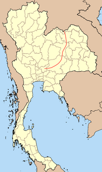
It is the first highway in Thailand to meet international standards, and the first highway in Thailand to use both asphalt and concrete. It received the name "Thanon Mittraphap" on 20 February 1957. The name literally means "Friendship Road". It is the main road that connects Isan (northeastern Thailand) across the Dong Phaya Yen Range. The highway begins at Saraburi, Phahonyothin Road (Highway 1) junction. It passes through the provinces of Nakhon Ratchasima, Khon Kaen, Udon Thani, and ends in Nong Khai, where it links with the Thai-Lao Friendship Bridge to Laos.
Six-lane expanded Mittraphap Road near Lam Takhong, Nakhon Ratchasima
Mittraphap Highway in Nong Khai
Thai-Lao Friendship Bridge
^Baker, Chris; Phongpaichit, Pasuk (2009). A History of Thailand (2nd, paper ed.). Cambridge University Press. p. 156. ISBN 9780521759151.
^Keyes, Charles F (March 1967). "Isan: Regionalism in Northeastern Thailand". Cornell Thailand Project; Interim Reports Series, No. 10(PDF). Ithaca: Department of Asian Studies, Cornell University. Retrieved 16 August 2019.
Thailand, along with Phahonyothin Road (Highway 1), MittraphapRoad (Highway 2) and Phetkasem Road (Highway 4). Sukhumvit Road begins in Bangkok, as a continuation...
highways in Thailand, which include MittraphapRoad (Highway 2), Sukhumvit Road (Highway 3), and Phet Kasem Road (Highway 4). It begins at Victory Monument...
highways in Thailand, along with Phahonyothin Road (Highway 1), MittraphapRoad (Highway 2), and Sukhumvit Road (Highway 3). At 1,274 km, route 4 is the longest...
Mittraphap highway may refer to one of two highways in Thailand Thailand Route 2, commonly known as MittraphapRoad Thailand Route 12 between Phitsanulok...
Junction. Saraburi can be reached via Phahonyothin Road (Highway 1). MittraphapRoad (Highway 2), a main road in the northeastern region. It has a beginning...
Terminal 21 Korat, was opened in December 2016 and is located on MittraphapRoad in Nakhon Ratchasima Province (also called Korat). Terminal 21 Pattaya...
some of the territory. After the war, the United States helped build MittraphapRoad from Saraburi to Nakhon Ratchasima. In April 1981 during another attempted...
Dong Phaya Yen were rapidly cleared following the construction of MittraphapRoad in 1955, which vastly opened up access to the area. Most of the land...
railway station and Thanon Chira Junction railway station. Road Highway 2 (MittraphapRoad) is the main route that connects nine districts in Nakhon Ratchasima...
attraction called Airways Land, featuring a cafe and event space, on MittraphapRoad in Sida District, Nakhon Ratchasima Province. 29 September 2015: A...
comprehensive air, road and rail connections. Most of the major highways that run through the northeastern Thailand, including MittraphapRoad, serve Udon Thani...
19th–20th centuries. The dish became more popular after the opening of MittraphapRoad in 1957, and has since become widely adopted by the ethnic Lao people...
attraction called Airways Land, featuring a cafe and event space, on MittraphapRoad in Sida District, Nakhon Ratchasima Province. 10 June 2023, Thai Airways...
Chabang seaport. Road The city is bisected by MittraphapRoad, also known as "Friendship Highway", or Asian Highway 2 (AH2), the road linking Bangkok to...
while other moved to Bangkok looking for work. With the opening of the MittraphapRoad and the northeastern railway connecting central Thailand to her northern...
Dong Phaya Yen were rapidly cleared following the construction of MittraphapRoad in 1955, which vastly opened up access to the area. When the Thai government...
the northeastern railway connecting Bangkok with Nakhon Ratchasima. MittraphapRoad passes south of town. "Population statistics 2007". Department of Provincial...
road-oriented period from the policy shift after the 1932 revolution. The MittraphapRoad, built with help from United States' foreign aid, was the first high-standard...
rest of Thailand. The most important of these was Highway 2 named the MittraphapRoad (Friendship Highway,) which links with Bangkok and Isan. and other...
producers, as well as other manufacturing industries and power plants. MittraphapRoad—designated National Highway 2—and the State Railway of Thailand's Northeastern...
Provincial Highway 2 (Taiwan) Thailand Route 2 (MittraphapRoad) O-2, a motorway in Turkey as the outer half ring road in Istanbul. SH-2 Highway in Albania from...
crops. Retail and trading are mainly located along Khok Matum and Mittraphaproad (12). The following companies play a role in the employment service:...
 Global Information
 Six-lane expanded Mittraphap Road near Lam Takhong, Nakhon Ratchasima
 Mittraphap Highway in Nong Khai
 Thai-Lao Friendship Bridge

