Location of the bootheel region centered on 36°15′N89°51′W / 36.250°N 89.850°W / 36.250; -89.850
Area
[1]
• Land
1,708.45 sq mi (4,424.9 km2)
Population
(2019)[2]
• Total
62,012
• Density
36.3/sq mi (14.0/km2)
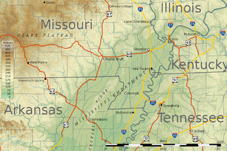
Topographic map of the bootheel and surrounding areas of Missouri and neighboring states.
The Missouri Bootheel is a salient (protrusion) located in the southeasternmost part of the U.S. state of Missouri, extending south of 36°30′ north latitude, so called because its shape in relation to the rest of the state resembles the heel of a boot. Strictly speaking, it is composed of some or all of the counties of Dunklin, New Madrid, and Pemiscot. However, the term is locally used to refer to the entire southeastern lowlands of Missouri located within the Mississippi Embayment, which includes parts of Butler, Mississippi, Ripley, Scott, Stoddard and extreme southern portions of Cape Girardeau and Bollinger counties. The largest city in the region is Kennett.
Until the 1920s, the district was a wheat-growing area of family farms. Following the invasion of the boll weevil, which ruined the cotton crop in Arkansas, planters moved in. They bought up the land for conversion to cotton commodity crops, bringing along thousands of sharecroppers.[3] After mechanization of agriculture and other changes in the 1930s, many black families left the area to go north in the Great Migration. These counties have predominantly white populations in the 21st century, although some have a significant number of black residents.
^"United States Summary: 2010, Population and Housing Unit Counts, 2010 Census of Population and Housing" (PDF). United States Census Bureau. September 2012. pp. V–2, 1 & 41 (Tables 1 & 18). Retrieved February 7, 2014.
^"Population, Population Change, and Estimated Components of Population Change: April 1, 2010 to July 1, 2019 (NST-EST2019-alldata)". Census.gov. United States Census Bureau. Archived from the original on January 26, 2020. Retrieved February 8, 2020.
^Peirce, Neal R.; Hagstrom, Jerry (1983). The Book of America: Inside the Fifty States Today. New York: Norton. p. 594. ISBN 0-393-01639-0.
The MissouriBootheel is a salient (protrusion) located in the southeasternmost part of the U.S. state of Missouri, extending south of 36°30′ north latitude...
protruding southward, including: The MissouriBootheel, a region in the southeastern part of the state The New Mexico Bootheel, a region in the southwestern...
last across the Missouri River) on the west. Whereas the northern and southern boundaries are straight lines, the MissouriBootheel extends south between...
long-tracked tornado – which traveled through northeast Arkansas, the MissouriBootheel, and northwest Tennessee – dissipated in western Obion County. Early...
southwestern tip. They also serves all of southeastern Missouri (including the MissouriBootheel area) and areas adjacent to the Mississippi River. 573...
War). On March 2, 1819, all of the Missouri Territory south of the parallel 36°30' north, except the MissouriBootheel between the Mississippi River and...
Plain Mississippi Delta Mississippi Gulf Coast Natchez Trace Boonslick Bootheel Dissected Till Plains Kansas City Metropolitan Area Lead Belt Little Dixie...
Valley being included. This definition also includes most of the MissouriBootheel. First employed by political analyst Kevin Phillips in his 1969 book...
district is the most rural district of Missouri, taking in rural southeastern Missouri, including the MissouriBootheel, as well as the cities of Cape Girardeau...
Upper South states. This includes areas such as eastern Arkansas, the MissouriBootheel, the Purchase area of Kentucky, West Tennessee, a Lower or Deep South...
counties, where the St. Francis River forms the western boundary of the MissouriBootheel, and in many places where the channel of the Mississippi has meandered...
Mississippi, western Tennessee and Kentucky, extreme southern Illinois, the MissouriBootheel, eastern and southern Arkansas, all of Louisiana, the southeast corner...
coping strategy from the sexual abuse he endured as a child in the MissouriBootheel, but he did remember that one. In the mid-1980s, Sells was living...
parallel 36° north approximately forms the southernmost boundary of the MissouriBootheel with the State of Arkansas. The 36th parallel passes through Duke...
 Global Information