Global Information Lookup Global Information

Mirigama Polling Division information


Mirigama
Polling Division
Location of Mirigama
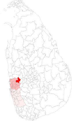
Coordinates: 7°13′18″N 80°06′57″E / 7.221769°N 80.115856°E / 7.221769; 80.115856
CountrySri Lanka
ProvinceWestern Province, Sri Lanka
Electoral DistrictGampaha Electoral District
Area
 • Total197.07 km2 (76.09 sq mi)
Population
 (2012)[1]
 • Total164,580
 • Density835/km2 (2,160/sq mi)
ISO 3166 codeEC-02E

The Mirigama Polling Division is a Polling Division in the Gampaha Electoral District, in the Western Province, Sri Lanka.

  1. ^ "Census of Population and Housing 2012". statistics.gov.lk. Department of Census and Statistics, Sri Lanka. 2012.

and 5 Related for: Mirigama Polling Division information

Request time (Page generated in 0.7939 seconds.)

Mirigama Polling Division

Last Update:

The Mirigama Polling Division is a Polling Division in the Gampaha Electoral District, in the Western Province, Sri Lanka. The winner of Mirigama has...

Word Count : 508

Banduragoda Grama Niladhari Division

Last Update:

400m 440yds    Banduragoda Grama Niladhari Division is a Grama Niladhari Division of the Mirigama Divisional Secretariat of Gampaha District of Western...

Word Count : 155

Mirigama Electoral District

Last Update:

general elections, the first under the PR system, though Mirigama continues to be a polling division of the multi-member electoral district. Key   Independent...

Word Count : 435

Gampaha Electoral District

Last Update:

Archived from the original on 2012-08-05. "General Election 2001 Final Polling Division Results" (PDF). Department of Elections, Sri Lanka.[permanent dead...

Word Count : 1446

1977 Sri Lankan parliamentary election

Last Update:

seats in the National State Assembly 85 seats were needed for a majority Winners of polling divisions. UNP in green, TULF in yellow and SLFP in blue....

Word Count : 631

PDF Search Engine © AllGlobal.net