Mingus Mountain (Yavapai: Hwa:lkyañaña) is a mountain located in the U.S. state of Arizona in the Black Hills mountain range. It is located within the Prescott National Forest traversed by State Route 89A approximately midway between Cottonwood and Prescott. The summit can be reached via Forest Service roads that branch off from State Route 89A. From the mountain, there are views of the Verde Valley, Sycamore Canyon Wilderness and the towns of Cottonwood, Jerome, and Clarkdale. The Woodchute Wilderness, north of the summit of 89A, also offers views and hiking trails. There are several National Forest campgrounds in the area and it is the transmitter location for Prescott full-service television station KAZT-TV and several low-power television stations serving Cottonwood, Clarkdale, Camp Verde and Prescott Valley. Mingus Mountain is also the premier flying site of the Arizona Hang Gliding and Paragliding Association.[3]
According to the book, Roadside History of Arizona, by Marshall Trimble, "Mingus Mountain was named for Joseph and Jacob Mingus, two brothers who settled in the area in the 1880s and later operated a sawmill near the base of the mountain".[4] Another source attributes the name to William Mingus (d. 1911, Prescott, Arizona), a pioneer prospector who lived and worked on Mingus Mountain in the 1870s.[5]
The Mingus Lookout Complex is a complex of fire tower and associated buildings at the top of the mountain, and is listed on the National Register of Historic Places.
The launching platform for hang gliding on Mingus Mountain
A hang glider preparing for launch at Mingus Mountain
^"Mingus Mountain". Geographic Names Information System. United States Geological Survey, United States Department of the Interior. Retrieved 2006-12-28.
^"Mingus". AZHPA.org. Retrieved 2014-02-06.
^Trimble, Marshall (1986). Roadside History of Arizona. Missoula: Mountain Press Pub. Co. ISBN 978-0878421978.
^Stone, Terrance L (2006). Grave history. Datura Books. p. 223. ISBN 978-0977854509.
MingusMountain (Yavapai: Hwa:lkyañaña) is a mountain located in the U.S. state of Arizona in the Black Hills mountain range. It is located within the...
album by Charles MingusMingus (Joni Mitchell album), 1979 jazz album by Joni Mitchell with Charles MingusMingusMingusMingusMingusMingus, 1963 album by...
112°11′16″W / 34.643399°N 112.187717°W / 34.643399; -112.187717 MingusMountain Academy is a private, all-girls alternative high school in Prescott...
Charles Mingus Jr. (April 22, 1922 – January 5, 1979) was an American jazz upright bassist, composer, bandleader, pianist, and author. A major proponent...
2 million people in the greater Phoenix area. The valley is overlooked by MingusMountain and the Mogollon Rim. The valley is one of three regions of viticulture...
Camelback Mountain (O'odham: Cew S-wegiom) is a mountain in Phoenix, Arizona, United States. The English name is derived from its shape, which resembles...
highway is notable for its scenic value as it winds over and through MingusMountain as well as passing through Sedona and the Oak Creek Canyon. The route...
Peak King Arthur Castle Kitt Peak Lost Wilson Mountain Lyell Butte Mica Mountain Miller Peak MingusMountain Mount Ajo Mount Elden Mount Graham Mount Hayden...
Mountains–Pima County Middle Mountains–S. La Paz County -- (N. Yuma County) Mineral Mountains, Arizona–Pinal County MingusMountain, (= "Black Hills")–Yavapai...
represented Mountain Spirits, who were believed by Yavapai to dwell in Four Peaks, McDowell Mountains, Red Mountain (near Fort McDowell), MingusMountain-(Black...
The Superstition Mountains (Yavapai: Wi:kchsawa) is a range of mountains in Arizona located to the east of the Phoenix metropolitan area. They are anchored...
Superstition Mountain (Yavapai: Wi:kchsawa, O'odham: Gakoḍk) is a prominent mountain and regional landmark located in the Phoenix metropolitan area of...
also at a 50 degree slope on solid bedrock, up against the slopes of MingusMountain. The 30,000 square foot building was designed to be fireproof-not one...
reference to the mountain. Other historic names included Squaw Tit Mountain, Phoenix Mountain and Vainom Do'ag, the Pima name for the mountain. As the term...
Zuni: Sunha K'hbchu Yalanne, Mojave: 'Amat 'Iikwe Nyava) are a volcanic mountain range in the San Francisco volcanic field in north central Arizona, just...
MingusMountain, (Black Hills (Arizona)) Verde Rim Red Rock Country; see Sedona and Village of Oak Creek, Arizona Bradshaw Mountains Granite Mountain...
Mingus Lookout Complex is a fire tower lookout complex atop MingusMountain in Prescott National Forest, in Arizona. It was listed on the National Register...
Phoenix Mountains are a mountain range located in central Phoenix, Arizona. With the exception of Mummy Mountain, they are part of the Phoenix Mountain Preserve...
Navajo Mountain (Navajo: Naatsisʼáán) is a peak in San Juan County, Utah, with its southern flank extending into Coconino County, Arizona, in the United...
Francisco Peak applied to this feature (apparently borrowed from San Francisco Mountain on which the peak stands). Thus the United States Board on Geographic Names...
e Mountains of Arizona Black Hills (Yavapai County) MingusMountain Black Mountains Boundary Cone Fortification Hill Mount Wilson Bradshaw Mountains Mount...
summit. Mountains portal Arizona portal List of mountains of the United States List of mountain peaks of the United States List of mountain ranges of...
The Dragoon Mountains is a range of mountains located in Cochise County, Arizona. The range is about 25 mi (40 km) long, running on an axis extending...
The Santa Rita Mountains (O'odham: To:wa Kuswo Doʼag), located about 40 miles (64 km) southeast of Tucson, Arizona, extend 26 miles (42 km) from north...
 Global Information
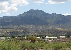

 The launching platform for hang gliding on Mingus Mountain
 A hang glider preparing for launch at Mingus Mountain
