Municipality in the Mexican state of Baja California
Municipality in Baja California, Mexico
Mexicali Municipality
Municipio de Mexicali
Municipality
Flag
Coat of arms
Motto(s):
Tierra Cálida (Warm Land)
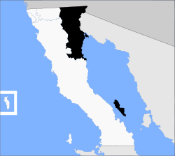
Location of Mexicali in Baja California.
Country
Mexico
State
Baja California
Municipal seat
Mexicali
Largest city
Mexicali
Municipality established
29 December 1953[1]
Government
• Municipal president
Norma Alicia Bustamante Martínez ( MORENA)
Area
• Total
13,700 km2 (5,300 sq mi)
Population
(2020)
• Total
1,049,792
• Density
77/km2 (200/sq mi)
Data source: [2]
Time zone
UTC−8 (Northwest (US Pacific))
• Summer (DST)
UTC−7 (Northwest)
INEGI code
002
Website
(in Spanish) Ayuntamiento de Mexicali
Source: Enciclopedia de los Municipios de México
Mexicali Municipality is a municipality (Spanish: municipio) in the Mexican state of Baja California. Its municipal seat (Spanish: cabecera municipal) is located in the city of Mexicali. As of 2020, the municipality had a total population of 1,049,792.[3] The municipality has an area of 13,700 km2 (5,300 sq mi). This includes many smaller outlying communities as well as the city of Mexicali. Also, the islands of Baja California located in the Gulf of California are part of the municipality, among them the mudflat islands at the mouth of the Colorado River (the largest one being Montague Island), Isla Ángel de la Guarda and the islands of the San Lorenzo Marine Archipelago National Park. Mexicali is the northernmost municipality of Latin America.
The city of Mexicali was founded in 1903, and its name is a portmanteau of Mexico and California, as is the name of Calexico, California across the border.
^(in Spanish) pp. 78–79, La Transformación de Baja California en Estado, 1931–1952 Archived 29 September 2011 at the Wayback Machine, Lawrence Douglas Taylor Hansen, Estudios Fronterizos, 1, No. 1 (January–June 2000), UABC, Mexicali, pp. 47–87.
^"México en cifras". January 2016.
^"México en cifras". January 2016.
and 17 Related for: Mexicali Municipality information
MexicaliMunicipality is a municipality (Spanish: municipio) in the Mexican state of Baja California. Its municipal seat (Spanish: cabecera municipal)...
is the seat of the MexicaliMunicipality, has a population of 689,775, according to the 2010 census, while the Calexico–Mexicali metropolitan area is...
Mexicali International Airport (Spanish: Aeropuerto Internacional de Mexicali); officially Aeropuerto Internacional General Rodolfo Sánchez Taboada (General...
into boroughs, or delegaciones. Mexicalimunicipality, for example, is divided into 14 boroughs besides the City of Mexicali, which comprises the municipal...
a list of presidents of MexicaliMunicipality in Baja California state, Mexico. The municipality includes the city of Mexicali. Rodolfo Escamilla Soto...
Los Algodones is a town and borough in the municipality of Mexicali, Baja California, Mexico. Located on the United States-Mexico border to the north and...
Mirador (1,171), classified as rural. MexicaliMunicipality – east Ensenada Municipality – south Tijuana Municipality – west San Diego County, California...
US-Mexico border in Mexicali at the northern point at San Felipe in the south. The highway is entirely inside the MexicaliMunicipality. However, a state...
Gulf of California (also known as the Sea of Cortez) in eastern MexicaliMunicipality in the north of the state of Baja California in northwesternmost...
Lerdo Landing is a ghost town in Baja California. It was originally located in Sonora, Mexico from 1872 to 1896. Later changes to the course of the Colorado...
Mount San Antonio (Los Angeles County) New River (Imperial County, MexicaliMunicipality) Nine Sisters (San Luis Obispo County) Ojai Valley (Ventura County)...
Bernardino, Riverside and Imperial counties in California, and MexicaliMunicipality in Baja California. It would be strongly felt (and potentially cause...
Gulf of California, as it did until irrigation in the Imperial Valley and Mexicali Valley dried it up before reaching there; other times it turned westward...
customary ribbon shirts and ribbon dresses. Cocopah people live in MexicaliMunicipality, Baja California (settlements of Campo Camerina (Colonia Terrenos...
Seven Wells Station was built at the site, of Salt or Seven Wells one of the wells developed by the Butterfield Overland Mail, as a part of its improvements...
La Chinesca is a neighborhood located in the Mexican city of Mexicali. The location is home to about 15,000 people of Chinese origin, historically the...
list includes information of cities from the Baja California municipalities of Mexicali, Ensenada, Playas de Rosarito, Tijuana and Tecate. Over 75% of...
 Global Information