Mountain range in Connecticut and Massachusetts, United States
Metacomet Ridge
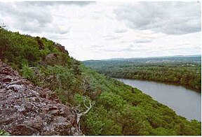
Traprock cliffs on Chauncey Peak, Connecticut
Highest point
Peak
Mount Toby
Elevation
1,269 ft (387 m)
Dimensions
Length
100 mi (160 km) north–south
Geography
Country
United States
States
Connecticut and Massachusetts
Geology
Formed by
Fault blocking
Age of rock
Triassic and Jurassic
Type of rock
Igneous and sedimentary
The Metacomet Ridge, Metacomet Ridge Mountains, or Metacomet Range of southern New England is a narrow and steep fault-block mountain ridge known for its extensive cliff faces, scenic vistas, microclimate ecosystems, and rare or endangered plants. The ridge is an important recreation resource located within 10 miles (16 km) of more than 1.5 million people, offering four long-distance hiking trails and over a dozen parks and recreation areas, including several historic sites. It has been the focus of ongoing conservation efforts because of its natural, historic, and recreational value, involving municipal, state, and national agencies and nearly two dozen non-profit organizations.[1][2]
The Metacomet Ridge extends from Branford, Connecticut, on Long Island Sound, through the Connecticut River Valley region of Massachusetts, to northern Franklin County, Massachusetts, 2 miles (3 km) short of the Vermont and New Hampshire borders for a distance of 100 miles (160 km). It is geologically distinct from the nearby Appalachian Mountains and surrounding uplands, and is composed of volcanic basalt (also known as trap rock) and sedimentary rock in faulted and tilted layers many hundreds of feet thick. In most cases, the basalt layers are dominant, prevalent, and exposed. The ridge rises dramatically from much lower valley elevations, although only 1,200 feet (370 m) above sea level at its highest, with an average summit elevation of 725 feet (221 m).[1][3]
^ ab"Metacomet-Mattabesett Trail Natural Resource Assessment" (PDF). Farnsworth, Elizabeth J. (2004). Archived from the original (PDF) on 7 August 2007. Retrieved June 14, 2015.
^United States Census Bureau. Data retrieved December 20, 2007.
USS Metacomet, an 1863 United States Navy ship The MetacometRidge, a 100-mile long mountain range in southern New England The 51-mile Metacomet Trail...
westernmost peak of the Holyoke Range and part of the 100-mile (160 km) MetacometRidge. The mountain is located in the Connecticut River Valley of western...
Haven and points west. West Rock Ridge is part of the narrow, linear MetacometRidge which extends from Long Island Sound near New Haven north through the...
The Metacomet Trail is a 62.7-mile (100.9 km) Blue-Blazed hiking trail that traverses the MetacometRidge of central Connecticut and is a part of the...
River Valley of Massachusetts. It is a subrange of the narrow, linear MetacometRidge that extends from Long Island Sound near New Haven, Connecticut north...
Farmington to Simsbury. Talcott Mountain is part of the narrow, linear MetacometRidge that extends from Long Island Sound near New Haven, Connecticut, north...
Connecticut River Valley of Massachusetts and part of the greater MetacometRidge which stretches from Long Island Sound to nearly the Vermont border...
more notable summits and sub–ranges that make up the crest of the MetacometRidge, a fault-block landform located in Connecticut and Massachusetts, known...
Mountains, Montana Little Wolf Mountains, Montana MetacometRidge, Connecticut and Massachusetts Traprock Ridge, Connecticut Mineral Mountains, Arizona Mineral...
miles west of the Connecticut River. It is part of the narrow, linear MetacometRidge that extends from Long Island Sound near New Haven, Connecticut, north...
Pocumtuck Range, also referred to as the Pocumtuck Ridge, is the northernmost subrange of the MetacometRidge mountain range of southern New England, itself...
rock ridges overlooking the city of Meriden and the Quinnipiac River Valley 900 feet (274 m) below. They are a subrange of the narrow, linear Metacomet Ridge...
Vermont, and The Berkshires in Massachusetts, and Connecticut, the MetacometRidge Mountains in Connecticut and south-central Massachusetts, and the Adirondack...
the Connecticut River Valley of Massachusetts and part of the larger MetacometRidge which stretches from Long Island Sound to nearly the Vermont border...
communities from Guilford, Connecticut, at Long Island Sound over the MetacometRidge, through the highlands of the Pioneer Valley of Massachusetts, to the...
narrow traprock mountain ridge located in the Connecticut River Valley of Massachusetts. It is part of the MetacometRidge which extends from Long Island...
metropolitan area to the south and west. Sitting at the southern end of the MetacometRidge, its geology is characterized by land of a level grade along the shores...
by the Hudson Highlands, and to the east, they are bordered by the MetacometRidge. They are on the average 1,000 ft (300 m) lower and less prominent...
are columns of trap rock. Basalt Mountain near Basalt, Colorado. The MetacometRidge of Connecticut and Massachusetts. The Watchung Mountains of New Jersey...
blocks produces much more dramatic results. Landforms (mountains, hills, ridges, lakes, valleys, etc.) are sometimes formed when the faults have a large...
 Global Information