Red Peak Fork, Illilouette Creek, Bridalveil Creek, South Fork Merced River
• right
Triple Peak Fork, Lyell Fork, Sunrise Creek, Tenaya Creek, Yosemite Creek, Cascade Creek, North Fork Merced River, Dry Creek
National Wild and Scenic River
Type
Wild, Scenic, Recreational
Designated
November 2, 1987
Sunrise over the Merced River as seen from Swinging Bridge in June 2023. Upper Yosemite Falls is visible on the left-hand side of the image. Demonstrated in this photo is the particularly high water level of the Merced River in 2023 as a result of the record snowpack received by the Sierra Nevada mountains.
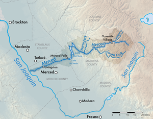
The Merced River (/mɜːrˈsɛd/), in the central part of the U.S. state of California, is a 145-mile (233 km)-long[1] tributary of the San Joaquin River flowing from the Sierra Nevada into the San Joaquin Valley. It is most well known for its swift and steep course through the southern part of Yosemite National Park, where it is the primary watercourse flowing through Yosemite Valley. The river's character changes dramatically once it reaches the plains of the agricultural San Joaquin Valley, where it becomes a slow-moving meandering stream.[2]
The river first formed as the Sierra Nevada rose about 10 million years ago, and sediment eroded from its canyon helped form the flat floor of the San Joaquin Valley. Glaciation during the ice ages carved the high elevation parts of the watershed, including Yosemite Valley, into their present shape. Historically, there was an extensive riparian zone which provided habitat for millions of migrating birds, and the river had one of the southernmost runs of chinook salmon in North America.
Miwok and Paiute people lived along the river for thousands of years before Spanish and Mexican military expeditions passed through in the early 19th century. The California Gold Rush brought many people into California and some settled in towns along the lower Merced River. A railroad was built along the Merced canyon, enabling mining and logging in the upper watershed, and later carrying tourists to Yosemite National Park. Conflicts between settlers and Native Americans resulted in wars, including the expulsion of the Ahwahnechee from Yosemite.
Large-scale irrigation was introduced to the San Joaquin Valley in the late 19th century, and led to the construction of numerous state, federal and privately owned dams, which blocked migrating salmon and caused a large decline in riparian habitat. Diversion of water for irrigation often reduces the river to a small stream by the time it reaches its mouth. Efforts to mitigate environmental damage include habitat conservation work, re-establishment of historic streamflow patterns, and the construction of a salmon hatchery.
^ abU.S. Geological Survey. National Hydrography Dataset high-resolution flowline data. The National Map Archived 2012-03-29 at the Wayback Machine, accessed March 11, 2011
^Fowler, Mia (1990). Missouri River management plan : Holter Dam to Great Falls, 1990 through 1994 /. [Helena?, Mont.]: The Dept. doi:10.5962/bhl.title.101406.
the MercedRiver in Yosemite Valley. Beyond the glacial moraine at the western end of the valley the river flows through the steep MercedRiver Canyon...
Dry Creek New Exchequer Dam and Lake McClure North Fork MercedRiver South Fork MercedRiver Alder Creek Bishop Creek Elevenmile Creek Rail Creek Bridalveil...
ink onto the paper. An example is Lodgepole Pines, Lyell Fork of the MercedRiver, Yosemite National Park (originally named Tamarack Pine), taken in 1921...
The January 1997 flood of the MercedRiver (flooded/flooded from the watershed/floodplain of the MercedRiver) occurred from December 31, 1996, to January...
fan of creeks and forks of the MercedRiver take drainage from the Sierra crest and combine at Merced Lake. The Merced then flows down to the end of its...
The North Fork MercedRiver is a tributary of the MercedRiver in Mariposa County, California. The river originates in the foothills of the Sierra Nevada...
Tuolumne River for 60 miles (97 km), passing well beyond Hetch Hetchy Valley. Merced Glacier flowed out of Yosemite Valley and into the MercedRiver Gorge...
joined by the Fresno and Chowchilla Rivers when they reach flood stage. Fifty miles (80 km) downstream, the MercedRiver empties into an otherwise dry San...
Merced Grove is a giant sequoia grove located about 3.6 km (2.2 mi) west of Crane Flat in the MercedRiver watershed of Yosemite National Park, California...
Happy Isles is a group of small isles in the MercedRiver in Yosemite National Park, California, USA. They are located at the easternmost end of the Yosemite...
the MercedRiver, starting at Happy Isles in Yosemite Valley, past Vernal Fall and Emerald Pool, to Nevada Fall. Along the trail, the MercedRiver is a...
half following damage from the 100-year flood of January 1997, when the MercedRiver damaged or destroyed numerous cabins and more than 100 hotel rooms in...
Stanislaus, Tuolumne, and MercedRiver tributaries). The southern third of the range is drained by the Kings, Kaweah, Tule, and Kern rivers, which flow into the...
at the MercedRiver, just southwest of Yosemite Village. (37°44′33″N 119°35′41″W / 37.74243°N 119.59461°W / 37.74243; -119.59461) The Merced is a tributary...
Rest and the High Sierra Camp at Merced Lake. Little Yosemite Valley is a tread on the glacial stairway of the MercedRiver that runs from Yosemite Valley...
The South Fork MercedRiver is the largest tributary of the MercedRiver. Most of the river flows within Yosemite National Park in the Sierra Nevada of...
Fresno County Hartnell College in Salinas, Monterey County Merced College in Merced, Merced County Modesto Junior College in Modesto, Stanislaus County...
Merced College is a public community college in Merced, California. In 1961, the Merced High and Le Grand High School Districts petitioned the State Board...
Yosemite Creek emerges from the base of the Lower Fall and flows into the MercedRiver nearby. Like many areas of Yosemite the plunge pool at the base of the...
Vernal Fall is a 317-foot (96.6 m) waterfall on the MercedRiver just downstream of Nevada Fall in Yosemite National Park, California. Like its upstream...
 Global Information