Global Information Lookup Global Information

Meramec River information


Meramec River
At Onondaga Cave State Park
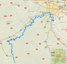
Path of the Meramec River [1]
Location
CountryUnited States
StateMissouri
RegionOzarks
CitiesSteelville, Missouri, Sullivan, Missouri, Pacific, Missouri, Valley Park, Missouri, Arnold, Missouri
Physical characteristics
Source 
 • locationDent County, Missouri
 • coordinates37°30′29″N 91°19′39″W / 37.50806°N 91.32750°W / 37.50806; -91.32750
 • elevation1,075 ft (328 m)
MouthMississippi River
 • location
Arnold, Missouri
 • coordinates
38°23′26″N 90°20′40″W / 38.39056°N 90.34444°W / 38.39056; -90.34444
 • elevation
350 ft (110 m)
Length229 mi (369 km)
Basin size3,980 sq mi (10,300 km2)
Discharge 
 • locationEureka, Missouri
 • average3,318 cu/ft. per sec.[1]
Basin features
Tributaries 
 • leftBourbeuse River
 • rightBig River

The Meramec River (/ˈmɛrɪmæk/), sometimes spelled Maramec River (the original US mapping spelled it Maramec but later changed it to Meramec), is one of the longest free-flowing waterways in the U.S. state of Missouri, draining 3,980 square miles (10,300 km2)[2] while wandering 218 miles (351 km)[3] from headwaters southeast of Salem to where it empties into the Mississippi River near St. Louis at Arnold and Oakville. The Meramec watershed covers six Missouri Ozark Highland counties—Dent, Phelps, Crawford, Franklin, Jefferson, and St. Louis—and portions of eight others—Maries, Gasconade, Iron, Washington, Reynolds, St. Francois, Ste. Genevieve, and Texas. Between its source and its mouth, it falls 1,025 feet (312 m). Year-round navigability begins above Maramec Spring, just south of St. James. The Meramec's size increases at the confluence of the Dry Fork, and its navigability continues until the river enters the Mississippi at Arnold, Missouri.

The Meramec River looking north from Route 66 State Park
  1. ^ "USGS Surface Water data for Missouri: USGS Surface-Water Annual Statistics".
  2. ^ Blanc, Caldwell, and Hawk. "Location"
  3. ^ Blanc, Caldwell, and Hawk. "Executive Summary"

and 11 Related for: Meramec River information

Request time (Page generated in 0.7917 seconds.)

Meramec River

Last Update:

The Meramec River (/ˈmɛrɪmæk/), sometimes spelled Maramec River (the original US mapping spelled it Maramec but later changed it to Meramec), is one of...

Word Count : 1150

Meramec

Last Update:

Meramec is a name for several places in the United States: Meramec River in Missouri Meramec Caverns on the Meramec River Meramec State Park in Missouri...

Word Count : 66

List of rivers of Missouri

Last Update:

Whitewater River Castor River Old River River aux Vases Meramec River Big River Terre Bleue Creek Andrews Branch Bourbeuse River Little Bourbeuse River Little...

Word Count : 998

Onondaga Cave State Park

Last Update:

Onondaga Cave State Park is a Missouri state park located on the Meramec River approximately 5 miles (8.0 km) southeast of the village of Leasburg. The...

Word Count : 2238

Meramec State Park

Last Update:

Meramec State Park is a public recreation area located near Sullivan, Missouri, about 60 miles from St. Louis, along the Meramec River. The park has diverse...

Word Count : 686

Pacific Palisades Conservation Area

Last Update:

Palisades Conservation Area is a conservation area located along the Meramec River where St. Louis, Jefferson, and Franklin counties meet in Missouri,...

Word Count : 281

Route 66 State Park

Last Update:

Route 66 State Park is a public recreation area located on the Meramec River at the site of the former town of Times Beach, Missouri. The state park encompasses...

Word Count : 469

Maramec Spring

Last Update:

Maramec Spring is located on the Meramec River near St. James in the east-central Ozarks of Missouri. The fifth largest spring in the state with an average...

Word Count : 623

Miami people

Last Update:

of Meramec River, possibly the name of a Miami-Illinois band named Myaarameekwa (″Ugly Fish, i.e. Catfish Band″) that lived along the Meramec River (″River...

Word Count : 4163

Ozarks

Last Update:

region. The Meramec River and its tributaries Huzzah Creek and Courtois Creek are found in the northeastern Ozarks. The Black and St. Francis rivers mark the...

Word Count : 6886

Mississippi River

Last Update:

Ohio River, the Middle Mississippi is 315 feet (96 m) above sea level. Apart from the Missouri and Meramec rivers of Missouri and the Kaskaskia River of...

Word Count : 14351

PDF Search Engine © AllGlobal.net