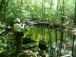
Vernal pond along the Menunkatuck Trail near the Iron Stream in the Timberlands town forest. Guilford, Connecticut.
Length
11.0 miles (17.7 km) [1]
Location
Connecticut
Designation
CFPA Blue-Blazed Trail
Use
hiking, cross-country skiing, snowshoeing, fishing, mountain biking (parts of the trail), other
Hazards
hunters, deer ticks, poison ivy
The Menunkatuck Trail is an 11.0-mile (17.7 km) Blue-Blazed hiking trail in Guilford, Connecticut and, currently, is almost entirely on protected land owned by the Town of Guilford, the Guilford Conservation Land Trust, the Regional Water Authority (RWA) and on Cockaponset State Forest land.
The mainline (official "Blue" "non-dot") trail is primarily a north / south linear trail with a northern trail head which terminates at the Mattabesett Trail near its southernmost point (approximately 1.3-mile (2.1 km) east of the Mattabesett Trail's intersection with (and "Bluff Head" parking lot on) Connecticut Route 77.
The current southern trail head terminates at a parking lot just outside the Town of Guilford's bulky waste site (and "Stump Dump" on Sullivan Drive just off Goose Lane (41°18′45″N72°40′28″W / 41.3125°N 72.6745°W / 41.3125; -72.6745) although the official Menunkatuck Trail blue-blazes end just after the Menunkatuck Trail splits southward from the "White Trail" in the Nut Plains Woods (Guilford Land Conservation Trust). South of Nut Plains Road the trail to the Guilford dump is marked with red-orange plastic ribbons tied to trees. Eventually the plan is for the Menunkatuck Trail to be extended to Long Island Sound (possibly via some road walks) but the trail currently is approximately 3.0-mile (4.8 km) directly due north of Guilford Harbor (and approximately 2.0-mile (3.2 km) due north of US I-95.).
The trail walk can be extended southward from just outside the waste site on Sullivan Drive by following a red-orange plastic ribbon marked trail through the Guilford town-owned East River Preserve to a trailhead on Clapboard Hill Road north of the intersection with Meadowlands. By walking from the East River Preserve trail head on Clapboard Hill Road and then down Meadowlands a ways the trail head to a nature trail on Audubon Society property (the Guilford Salt Meadows Sanctuary) can be found and can extend the walk a bit farther.
^
Colson, Ann T. (2006). Connecticut Walk Book West (19th ed.). Connecticut Forest and Park Association. ISBN 0-9619052-6-3.
The MenunkatuckTrail is an 11.0-mile (17.7 km) Blue-Blazed hiking trail in Guilford, Connecticut and, currently, is almost entirely on protected land...
a now (2013) complete connector trail (the MenunkatuckTrail) from the southernmost location of the Mattabesett Trail (in northern Guilford, Connecticut)...
Westwoods Trails is an extensive hiking trail system in Guilford, Connecticut. The trail system has approximately 39 miles (63 km) of trails with features...
million restoration. It now includes a visitors' center and museum, hiking trails, and a picnic area. William Gillette's "castle", called Seventh Sister and...
Regicides Trail is a Blue-Blazed hiking trail, about 7 miles (11 km) long, roughly following the edge of a diabase, or traprock, cliff northwest of New...
Farmington Canal Heritage Trail is an 82-mile (132 km) multi-use rail trail located in Connecticut and Massachusetts. The trail was built on former New...
The Ives Trail and Greenway is a 20-mile (32 km) hiking trail in the Housatonic Valley Region (also known as Greater Danbury). Its route connects Ridgefield...
mountain biking trails in the state. Among them are the Lookout Trail and the Pond Trail, which is a side trail that loops off the Deep Woods Trail. Rock climbing...
The Quinebaug Trail is a 8.1-mile (13.0 km) Connecticut hiking trail and is one of the Blue-Blazed hiking trails maintained by the Connecticut Forest and...
The Nayantaquit Trail is a 7-mile (11 km) Blue-Blazed hiking trail system in Lyme Connecticut and is entirely in the Nehantic State Forest western block...
center. The park's hiking trails grant access to the adjacent Pootatuck State Forest. Trails From the west side, the main trail starts from the north end...
campground. The park's trail system, which is used for hiking and cycling, includes a five-mile trail that tours the entire park. Trails also connect Gay City...
allow. Events and activities The park offers educational films, guided trail walks, and lectures. Warm-month activities include footprint track casting...
51-site campground, picnic, fish, and hike the blue-blazed Macedonia Ridge Trail, which crosses Cobble Mountain and other peaks. The park's first 1,552 acres...
The Metacomet Trail is a 62.7-mile (100.9 km) Blue-Blazed hiking trail that traverses the Metacomet Ridge of central Connecticut and is a part of the newly...
watershed land stretching from the Glastonbury border north to Case Pond. Some trails lead south across the Glastonbury border to a larger area of land owned...
by hemlock. Hiking trails The Connecticut Department of Energy and Environmental Protection (CT DEEP) manages a 20-mile (32 km) trail system based around...
The Shenipsit Trail is a Blue-Blazed hiking trail located in Central Connecticut between 3.5 and 7 miles (11 km) east of the Connecticut River. It runs...
at lower elevations and trails can be lost in the thick forest density. The park and forest have over 35 miles (56 km) of trails, including several around...
The Salmon River Trail is a 6.9-mile (11.1 km) Blue-Blazed hiking trail in Colchester, and East Hampton, Connecticut and is almost entirely in the Salmon...
Pequot Trail is a 7.6-mile (12.2 km) Blue-Blazed Trail, a hiking trail maintained by the Connecticut Forest and Park Association. The Pequot Trail extends...
The Nipmuck Trail is a Blue-Blazed hiking trail system which meanders through 34.5 miles (55.5 km) of forests in northeast Connecticut. It is maintained...
the wolf was codified. Today, the Wolf Den is accessible from a hiking trail off of Wolf Den drive in Mashamoquet Brook State Park, a +1,000-acre (400 ha)...
 Global Information