 Global Information
Mavulis Island information
Native name: Y'Ami Amianan | |
|---|---|
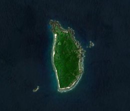 Satellite image of the island | |
 Mavulis Island Location in Batanes  Mavulis Island Location in Luzon  Mavulis Island Location in Philippines | |
| Geography | |
| Location | Luzon Strait |
| Coordinates | 21°6′47″N 121°57′6″E / 21.11306°N 121.95167°E |
| Archipelago | Batanes Group of Islands |
| Area | 1.1 km2 (0.42 sq mi) |
| Administration | |
Philippines | |
| Region | Cagayan Valley |
| Province | Batanes |
| Municipality | Itbayat |
| Demographics | |
| Population | uninhabited |
| Additional information | |
 | |
Mavulis Island is the northernmost of the Batanes Islands and the northernmost island in the Philippines. It is part of the province of Batanes. The island is uninhabited but it is guarded by the military. It is also frequently visited by local fishermen (mostly from Itbayat and Basco) for fishing adventures.
The island has a newly constructed military and fishermen shelter, a water desalination plant, a helipad, lighthouse, and a flagpole on the top of the hill in the island.[1][2][3]
The island also hosts the northernmost flagpole in the country.[3]
This island is closer to Taiwan than the capital Manila, at 733 km away from Manila, and 98 km to the nearest Taiwanese territory (uninhabited Hsiao-lan-yu island (Lesser Orchid)), and 142 km from Cape Eluanbi, the southernmost point of Taiwan mainland.[not verified in body] The distance to Taipei is 272 miles (473 km).
- ^ Mangosing, Frances (28 May 2019). "Multi-purpose shelter for fishers, troops unveiled in northernmost PH isle". Philippine Daily Inquirer. Retrieved 28 May 2019.
- ^ Dumlao, Artemio (26 April 2019). "Fishermen's shelter completed on Batanes island". The Philippine Star. Retrieved 28 May 2019.
- ^ a b Baccay, Oliver T. "Raise your flag". pia.gov.ph. Philippine Information Agency. Retrieved 13 May 2020.