The Marokopa River is a river of the Waikato Region of New Zealand.[1] It flows west to join the Tasman Sea at Marokopa. The main part of the river is 40.5 km (25.2 mi) long, with about 533 km (331 mi) of tributaries. The catchment is some 364 km2 (141 sq mi).[2]
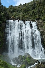
Near Te Anga, the river flows over the picturesque[3] Marokopa Falls. The settlements of Awamarino and Marokopa are located on the river's banks.
Trout were introduced about 1910.[4] The lower river is polluted.[5]
^"Place name detail: Marokopa River". New Zealand Gazetteer. New Zealand Geographic Board. Retrieved 23 April 2010.
^"Environmental monitoring data for Marokopa River". Land, Air, Water Aotearoa (LAWA). Retrieved 10 March 2019.
^Marokopa Falls walk ("often described as the most beautiful in the country", from the New Zealand Department of Conservation website. Accessed 2013-07-20.)
^"King Country Chronicle, Local and General News". paperspast.natlib.govt.nz. 26 February 1910. Retrieved 10 March 2019.
^"Marokopa River at Speedies Rd (Off Te Anga Rd) River Quality". Land, Air, Water Aotearoa (LAWA). Retrieved 10 March 2019.
The MarokopaRiver is a river of the Waikato Region of New Zealand. It flows west to join the Tasman Sea at Marokopa. The main part of the river is 40...
Harbour. The meshblock includes the coastal township of Marokopa, at the mouth of the MarokopaRiver, and the south side of the small village of Awamarino...
State Highway 3 in the MarokopaRiver area, leads past the Waitomo Caves, Mangapohue Natural Bridge, Piripiri Caves, and Marokopa Falls. Numerous other...
The Tawarau River is a river of the southern Waikato Region of New Zealand's North Island. It flows northwest to reach the MarokopaRiver 12 kilometres...
and Waikato region of New Zealand's North Island. MarokopaRiver runs through the area. The river is not safe to swim in due to high rates of E. coli...
Maramataha River Mararoa River Marchburn RiverMarokopaRiver Maropea River Martyr River Maruia River Mason River Mata River Matahaka River Mataikona River Matakana...
It is located 9 kilometres (5.6 mi) from Marokopa, Waikato, New Zealand, above the valley of the MarokopaRiver. Castle Craig Rock is a type of flaggy Limestone...
Waikato River. ^ This stage is sometimes further divided into Kiriteherean (lower) and Marokopan (upper). These are named after the MarokopaRiver and the...
consists of two rock arches formed by the Mangapohue Stream in the MarokopaRiver valley near Waitomo, New Zealand. The 17 m high limestone arches are...
there, she passed Lake Taharoa, Taumatakanae, and Harihari, crossed the MarokopaRiver at the coast, crossed Kiri-te-here stream and reached the base of Mount...
Ngāti Huiao, Ngāti Peehi, and Ngāti Te Kanawa Marokopa marae and Miromiro i te Pō wharenui, in Marokopa, shared with Ngāti Peehi, and Ngāti Te Kanawa...
Mataroa (died 1925) who lived in Nukuhakere/Nukuhakari, half way between Marokopa and Awakino. See "Mataroa, Bella (ARC2001-241)". Archived from the original...
Herangi Range is a range of hills south of Marokopa and north of Awakino, in the Waikato region of New Zealand, reaching to the Tasman Sea at Tapirimoko...
three years before the battle. Pikauterangi, a chief of Ngāti Toa from the Marokopa district was aggrieved over the poor distribution of the kahawai fish harvest...
Waikato Region Maraetotara Falls 16 metres (52 ft) Hawke's Bay Region Marokopa Falls 35 metres (115 ft) Waikato Region Maruia Falls West Coast Region...
continuously (except for maintenance), and include all geothermal and run-of-the-river hydroelectric plants, which must 'use it or lose it'. Intermediate generators...
the wider area. It features the only publicly accessible beach between Marokopa and Awakino. The only way to access the beach is through a walking track...
to crew shortage. On 19 July 2021, a ferry service began on the Waikato River, linking Swarbrick's Landing and Braithwaite Park with the museum and gardens...
Alaska Shipwrecks (Y) Bawal Jr., Raymond A. (2008). Ships of the St. Clair River. St. Clair, Michigan: Inland Expressions. p. 90. ISBN 978-0-9818157-1-8...
 Global Information