 Global Information
Manganuioteao River information
| Manganuioteao River | |
|---|---|
 | |
 | |
| Etymology | Maori meaning "great stream of the world" |
| Native name | Manganui o te Ao (Māori) |
| Location | |
| Country | New Zealand |
| Region | Manawatū-Whanganui |
| District | Ruapehu |
| Settlements | Orautoha |
| Physical characteristics | |
| Source | Mount Ruapehu |
| • coordinates | 39°16′33″S 175°32′7″E / 39.27583°S 175.53528°E |
| • elevation | 2,000 m (6,600 ft) |
| Mouth | Whanganui River |
• coordinates | 39°25′S 175°03′E / 39.417°S 175.050°E |
• elevation | 62 m (203 ft) |
| Length | 81 km (50 mi) |
| Basin features | |
| Progression | Manganuioteao River → Whanganui River |
| River system | Whanganui River |
| Tributaries | |
| • left | Mangaturuturu River |
| • right | Makatote River |
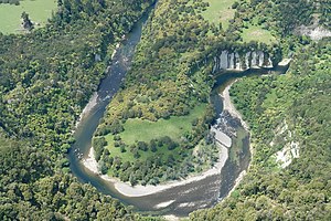
The Manganuioteao River (official name since 22 August 1985, also known as Manganui o te Ao River and shown on older maps as Manganuiateau River)[1] is a river of the centre of New Zealand's North Island. It has its source in numerous streams and small rivers which flow west from the slopes of Mount Ruapehu, though the main course of the river flows predominantly southwest through rugged hill country to meet with the Whanganui River 10 kilometres (6 mi) north of Pipiriki, at the edge of the Whanganui National Park.
The New Zealand Ministry for Culture and Heritage gives a translation of "great stream of the world" for Manganui-o-te-Ao.[2] Other translations have been "Great river of light", or "Wide open valley with plenty of daylight".[1]
- ^ a b "NZGB Gazetteer". gazetteer.linz.govt.nz. Retrieved 27 June 2021.
- ^ "1000 Māori place names". New Zealand Ministry for Culture and Heritage. 6 August 2019.