 Global Information
Malepunyo Mountain Range information
| Mount Malarayat | |
|---|---|
| Mount Malepunyo | |
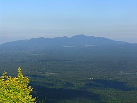 Malepunyo Range as seen from Tagaytay | |
| Highest point | |
| Elevation | 1,077 m (3,533 ft) |
| Parent peak | Bagwis Peak |
| Listing | Inactive volcano |
| Coordinates | 13°57′48″N 121°14′23″E / 13.96326°N 121.23971°E |
| Geography | |
 Mount Malarayat Location within the Philippines | |
| Location | Luzon |
| Country | Philippines |
| Region | Calabarzon |
| Province |
|
| Cities and municipalities |
|
| Geology | |
| Age of rock | Pliocene [1] |
| Mountain type | Stratovolcano |
| Volcanic arc/belt | Macolod Corridor |
| Last eruption | Pleistocene |
| Climbing | |
| Easiest route | from Lipa City, Batangas |
Malepunyo Range (also known as Malipunyo Range[2] or Mount Malarayat) is an extinct volcano located in Luzon. The mountain range is located between the provinces of Batangas, Laguna and Quezon. It is popular among mountaineers, and has three interconnected destinations: Mt. Malepunyo, the highest; Bagwis Peak (also known as Mt. Susong-Cambing); and Mount Dalaga (also known as Manabu Peak).
- ^ Frederick L. Wernstedt, Joseph Earle Spencer. "Philippine Island World: a physical, cultural and regional directory", p.21.
- ^ Philippine Commission. "Annual Reports of the War Department, 1906, Vol. 9", pg. 384. Washington Government Printing Office, 1907.