68.6 ft (20.9 m) (total width)[2] 54 ft (16 m) (road width) 38.1 ft (11.6 m) (depth)[2]
Height
552 ft (168 m) (tower height);[2] 200 ft (61 m) (deck height)[1]
Longest span
3,800 ft (1,158 m)[2]
Clearance below
155 ft (47 m)[1]
History
Designer
David B. Steinman
Opened
November 1, 1957 (November 1, 1957)
Statistics
Daily traffic
11,600
Toll
$2.00 per axle for passenger vehicles ($4.00 per car). $5.00 per axle for motor homes, and commercial vehicles.[3]
Location
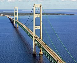
The Mackinac Bridge (/ˈmækənɔː/MAK-ə-naw; also referred to as the Mighty Mac or Big Mac)[4] is a suspension bridge that connects the Upper and Lower peninsulas of the U.S. state of Michigan. It spans the Straits of Mackinac, a body of water connecting Lake Michigan and Lake Huron, two of the Great Lakes. Opened in 1957, the 26,372-foot-long (4.995 mi; 8.038 km)[1] bridge is the world's 27th-longest main span and is the longest suspension bridge between anchorages in the Western Hemisphere.[5] The Mackinac Bridge is part of Interstate 75 (I-75) and the Lake Michigan and Huron components of the Great Lakes Circle Tour across the straits; it is also a segment of the U.S. North Country National Scenic Trail. The bridge connects the city of St. Ignace to the north with the village of Mackinaw City to the south.
Envisioned since the 1880s, the bridge was designed by the engineer David B. Steinman and completed in 1957 only after many decades of struggles to begin construction.[6] The bridge has since become an iconic symbol of the state of Michigan.[7][8][9]
^ abcdMackinac Bridge Authority (n.d.). "Facts & Figures". Mackinac Bridge Authority. Archived from the original on January 22, 2018. Retrieved January 22, 2018.
^ abcdMackinac Straits Bridge at Structurae. Retrieved January 30, 2010.
^Mackinac Bridge Authority (2010). "Mackinac Bridge Fare Schedules". Mackinac Bridge Authority. Archived from the original on December 22, 2009. Retrieved January 30, 2010.
^"'Mighty Mac' Bridge Run". St. Ignace Chamber of Commerce. 2017. Retrieved September 8, 2017.
^Cite error: The named reference mba-about was invoked but never defined (see the help page).
^Mackinac Bridge Authority (n.d.). "History of the Bridge, Mackinac Bridge". Mackinac Bridge Authority. Retrieved June 10, 2023.
^Matheny, Keith (October 29, 2017). "The Mackinac Bridge turns 60 and still looks good: How long can it last?". Detroit Free Press. Retrieved March 28, 2024.
^"Light The Mackinac Bridge". Mackinaw City & Mackinac Island Reviews, Comments & Attractions. Archived from the original on June 10, 2023. Retrieved June 10, 2023.
^"Governor Granholm Signs Legislation Codifying Mackinac Bridge Agreement" (Press release). Office of the Governor. December 28, 2005. Retrieved March 28, 2024.
The MackinacBridge (/ˈmækənɔː/ MAK-ə-naw; also referred to as the Mighty Mac or Big Mac) is a suspension bridge that connects the Upper and Lower peninsulas...
The MackinacBridge Walk is an annual event held every Labor Day since 1958 in Michigan in which people may walk the length of the MackinacBridge. Walkers...
state of Michigan's Upper and Lower Peninsulas, traversed by the MackinacBridge. The main strait is 3+1⁄2 miles (5.6 kilometers) wide with a maximum...
The MackinacBridge Authority is an independent state agency of the U.S. state of Michigan that operates the MackinacBridge across the Straits of Mackinac...
Fort Mackinac (/ˈmækənɔː/ MAK-ə-naw) is a former British and American military outpost garrisoned from the late 18th century to the late 19th century in...
Verrazano-Narrows Bridge, Golden Gate Bridge and MackinacBridge had a longer span in 1973). The Bosphorus Bridge remained the longest suspension bridge in Europe...
generally northward through Detroit, Pontiac and Bay City, crosses the MackinacBridge, and ends at the Canadian border in Sault Ste. Marie. The freeway runs...
Chesapeake Bay Bridge, but that role is now filled by private companies. The MackinacBridge Authority, which oversees the MackinacBridge connecting Michigan's...
Franklin, Ohio MackinacBridge, a bridge over the Straits of Mackinac Old Mackinac Point Lighthouse, a lighthouse in Mackinaw City Fort Mackinac, a British...
Peninsula by the Straits of Mackinac, a five-mile (8 km) channel that joins Lake Huron to Lake Michigan. The MackinacBridge connects the peninsulas. Michigan...
longest suspension bridges are listed according to the length of their main span (i.e., the length of suspended roadway between the bridge's towers). The length...
of Michigan; it is separated from the Lower Peninsula by the Straits of Mackinac. It is bounded primarily by Lake Superior to the north, separated from...
city of Detroit before turning northwesterly and northward to the MackinacBridge where the freeway crosses the strait between Lakes Huron and Michigan...
people and goods across the Straits of Mackinac to the car-free Mackinac Island but before the MackinacBridge was built, large numbers of ferries carried...
longest arch bridge spans List of longest masonry arch bridge spans List of longest cantilever bridge spans List of longest cable-stayed bridge spans List...
1993, and remains the tallest bridge in the United States. MackinacBridge (USA, 1957), the longest suspension bridge between anchorages in the Western...
Mackinaw City just east of the MackinacBridge. The lighthouse was constructed in 1892 along the Straits of Mackinac at the junction of Lake Michigan...
rugged terrain) or "trolls" (because, being south of the MackinacBridge, they "live under the bridge"). The Lower Peninsula is bounded on the west by Lake...
Interstate, US and state highways in Michigan with the exception of the MackinacBridge. Other responsibilities that fall under MDOT's mandate include airports...
"How to Build a Better Bridge". New York Sun. Archived from the original on 2007-11-14. Retrieved 2007-10-26. "MackinacBridge Victim Is Recovered". Madison...
 Global Information