 Global Information
Mackenzie River information
| Mackenzie River French: Le fleuve Mackenzie, Slavey: Deh-Cho, Gwich'in: Nagwichoonjik, Inuvialuktun: Kuukpak, Michif: Grande Rivière | |
|---|---|
 The Mackenzie River in August 2009 | |
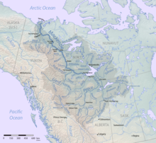 Map of the Mackenzie River watershed | |
| Etymology | Alexander Mackenzie, explorer |
| Location | |
| Country | Canada |
| Territories |
|
| Cities |
|
| Physical characteristics | |
| Source | Great Slave Lake |
| • location | Fort Providence |
| • coordinates | 61°12′15″N 117°22′31″W / 61.20417°N 117.37528°W |
| • elevation | 156 m (512 ft) |
| 2nd source | Most distant source of the Mackenzie–Slave–Peace–Finlay–Thutade system |
| • location | Headwater of Thutade Creek: a glacier snout on the south-west slopes of Alma Peak. |
| • coordinates | 56°44′53″N 127°30′38″W / 56.74806°N 127.51056°W |
| • elevation | 1,990 m (6,530 ft) |
| Mouth | Arctic Ocean |
• location | Beaufort Sea, Inuvik Region |
• coordinates | 68°56′23″N 136°10′22″W / 68.93972°N 136.17278°W |
• elevation | 0 m (0 ft) |
| Length | 4,241 km (2,635 mi)[1] |
| Basin size | 1,783,912 km2 (688,772 sq mi) to 1,805,200 km2 (697,000 sq mi)[1][2] |
| Width | |
| • minimum | 500 m (1,600 ft)[1][3] |
| • average | 1,600 m (5,200 ft) to 3,200 m (10,500 ft)[2] |
| • maximum | 6,000 m (20,000 ft) to 7,000 m (23,000 ft)[3] |
| Depth | |
| • average | 8 m (26 ft) to 9 m (30 ft)[1] |
| • maximum | 40 m (130 ft) to 45 m (148 ft)[1][3] |
| Discharge | |
| • location | Mackenzie Delta, Beaufort Sea, Canada |
| • average | (Period of data: 1948-1988)10,338 m3/s (365,100 cu ft/s)[4]
(Period of data: 1984-2018)310 km3/a (9,800 m3/s)[4] (Period of data: 1973-2011)10,300 m3/s (360,000 cu ft/s)[5][1] 9,910 m3/s (350,000 cu ft/s)[1] to 12,000 m3/s (420,000 cu ft/s)[6] |
| Discharge | |
| • location | Tsiigehtchic (Arctic Red - Basin size: 1,680,000 km2 (650,000 sq mi) to 1,717,754 km2 (663,229 sq mi)[4]) |
| • average | (Period of data: 1971-2015)9,211 m3/s (325,300 cu ft/s)[4] (Period of data: 1940-2017)288 km3/a (9,100 m3/s)[4] |
| • minimum | 2,180 m3/s (77,000 cu ft/s)[7] |
| • maximum | 35,000 m3/s (1,200,000 cu ft/s)[7] |
| Discharge | |
| • location | Fort Simpson (Basin size: 1,270,000 km2 (490,000 sq mi)[8] |
| • average | (Period of data: 1938-2000) 6,768.85 m3/s (239,040 cu ft/s)[8] |
| • minimum | 1,590 m3/s (56,000 cu ft/s)[8] |
| • maximum | 19,700 m3/s (700,000 cu ft/s)[8] |
| Basin features | |
| Tributaries | |
| • left | Liard River, Keele River, Arctic Red River, Peel River |
| • right | Great Bear River |
The Mackenzie River (French: Fleuve (de) Mackenzie; Slavey: Deh-Cho [tèh tʃʰò], literally big river; Inuvialuktun: Kuukpak [kuːkpɑk], literally great river) is a river in the Canadian boreal forest. It forms, along with the Slave, Peace, and Finlay, the longest river system in Canada, and includes the second largest drainage basin of any North American river after the Mississippi.
The Mackenzie River flows through a vast, thinly populated region of forest and tundra entirely within the Northwest Territories in Canada, although its many tributaries reach into five other Canadian provinces and territories. The river's main stem is 1,738 kilometres (1,080 mi) long, flowing north-northwest from Great Slave Lake into the Arctic Ocean, where it forms a large delta at its mouth. Its extensive watershed drains about 20 percent of Canada.[9] It is the largest river flowing into the Arctic from North America, and including its tributaries has a total length of 4,241 kilometres (2,635 mi), making it the thirteenth longest river system in the world.[10]
The ultimate source of the Mackenzie River is Thutade Lake, in the Northern Interior of British Columbia. The Mackenzie valley is believed to have been the path taken by prehistoric peoples during the initial human migration from Asia to North America over 10,000 years ago, despite sparse evidence.[citation needed] The Inuvialuit, Gwich'in and other Indigenous peoples lived along the river for thousands of years. The river provided the major route into Canada's northern interior for early European explorers.
Economic development remains limited along the river. During the 19th century, fur trading became a lucrative business, but this was affected by harsh weather conditions.[11] The discovery of oil at Norman Wells in the 1920s began a period of industrialization in the Mackenzie valley. Metallic minerals have been found along the eastern and southern edges of the basin; these include uranium, gold, lead, and zinc. Agriculture remains prevalent along the south, particularly in the Peace River area. Various tributaries and headwaters of the river have been developed for hydroelectricity production, flood control and irrigation.
- ^ a b c d e f g "Mackenzie River". 25 May 2014.
- ^ a b "Mackenzie River | river, Canada | Britannica". www.britannica.com.
- ^ a b c "Free topographic maps, elevation, terrain". Topographic maps.
- ^ a b c d e "Arctic Program > Home". www.arctic.noaa.gov.
- ^ Yang, Daqing; Shi, Xiaogang; Marsh, Philip (4 September 2015). "Variability and extreme of Mackenzie River daily discharge during 1973–2011". Quaternary International. 380–381: 159–168. Bibcode:2015QuInt.380..159Y. doi:10.1016/j.quaint.2014.09.023.
- ^ Panagiotopoulos, Christos; Sempéré, Richard; Jacq, Violaine; Charrière, Bruno (20 November 2014). "Composition and distribution of dissolved carbohydrates in the Beaufort Sea Mackenzie margin (Arctic Ocean)" (PDF). Marine Chemistry. 166: 92–102. doi:10.1016/j.marchem.2014.09.004. S2CID 128646221.
- ^ a b Yang, Daqing; Shi, Xiaogang; Marsh, Philip (September 2015). "Variability and extreme of Mackenzie River daily discharge during 1973–2011". Quaternary International. 380–381: 159–168. Bibcode:2015QuInt.380..159Y. doi:10.1016/j.quaint.2014.09.023.
- ^ a b c d "MACKENZIE RIVER AT FORT SIMPSON". www.r-arcticnet.sr.unh.edu.
- ^ Scheffel, Richard L.; Wernet, Susan J., eds. (1980). Natural Wonders of the World. United States of America: Reader's Digest Association. p. 220. ISBN 978-0-89577-087-5.
- ^ Cite error: The named reference
riversofcanadawas invoked but never defined (see the help page). - ^ Robinson, J. Lewis (18 October 2019). "Mackenzie River". Encyclopædia Britannica.