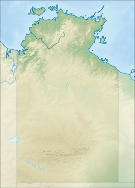
The interim Australian bioregions, with the MacDonnell Ranges in red
Area
39,294 km2 (15,171.5 sq mi)
Localities around MacDonnell Ranges:
Great Sandy Desert
Burt Plain
Channel Country
Great Sandy Desert
MacDonnell Ranges
Simpson Strzelecki Dunefields
Great Sandy Desert
Finke
Simpson Strzelecki Dunefields
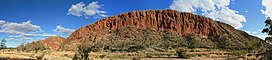
The MacDonnell Ranges, or Tjoritja in Arrernte, is a mountain range located in southern Northern Territory. MacDonnell Ranges is also the name given to an interim Australian bioregion broadly encompassing the mountain range, with an area of 3,929,444 hectares (9,709,870 acres).[1][2] The range is a 644 km (400 mi) long series of mountains in central Australia, consisting of parallel ridges running to the east and west of Alice Springs. The mountain range contains many spectacular gaps and gorges as well as areas of Aboriginal significance.
The ranges were named after Sir Richard MacDonnell (the Governor of South Australia at the time) by John McDouall Stuart, whose 1860 expedition reached them in April of that year. The Horn Expedition investigated the ranges as part of the scientific expedition into central Australia. Other explorers of the range included David Lindsay and John Ross.
The MacDonnell Ranges were often depicted in the paintings of Albert Namatjira.[3]
^Environment Australia. "Revision of the Interim Biogeographic Regionalisation for Australia (IBRA) and Development of Version 5.1 - Summary Report". Department of the Environment and Water Resources, Australian Government. Archived from the original on 5 September 2006. Retrieved 31 January 2007.
^IBRA Version 6.1 Archived 2006-09-08 at the Wayback Machine data
^Joanne Lane (5 September 2009). "Drawn by a legend". theage.com.au. Fairfax Digital. Retrieved 17 November 2009.
The MacDonnellRanges, or Tjoritja in Arrernte, is a mountain range located in southern Northern Territory. MacDonnellRanges is also the name given to...
bioregions – Burt Plain, Central Ranges, Finke, and MacDonnellRanges. This ecoregion includes the Central Australian Mountain Ranges Centres of Plant Diversity...
MacDonnellRanges. It is the highest peak in the Northern Territory, and the highest peak on the Australian mainland west of the Great Dividing Range...
It follows the West MacDonnellRanges, sometimes along the ridge line, other times on the plain below, in the West MacDonnell National Park. Finke River...
ten deserts in central and western Australia, the Inland Ranges, such as the MacDonnellRanges, which provide topographic variation across the flat plains...
him, including MacDonnell Road in Hong Kong and the MacDonnellRanges and Sir Richard Peninsula in Australia. Richard Graves MacDonnell was born in Dublin...
Simpsons Gap (Arrernte: Rungutjirpa) is one of the gaps in the West MacDonnellRanges in Australia's Northern Territory. It is located 18 kilometres west...
Arrernte people. The eastern MacDonnellRanges was formed by the Ayepe-arenye, while the western portion of the ranges was formed by Ntyarlke. The Arrernte's...
Territory, central Australia. The origins of the Todd River are in the MacDonnellRanges, where it flows past the Telegraph Station, almost through the centre...
It was created in 1974, and derived its name from the nearby MacDonnellRanges. MacDonnell was an almost entirely rural electorate, covering 333,398.61 km2...
Bloods Range Hann Range Kelly Hills MacDonnellRanges Mann Ranges Mitchell Ranges Musgrave Ranges Olia Chain Petermann Ranges Wellington Range Bellenden...
Chile Arthur Range Blue Mountains Flinders Ranges Great Dividing Range Hammersley RangeMacDonnellRanges Pelion Range Stirling Range Jayawijaya Mountains...
the town of Alice Springs and its immediate surrounds including the MacDonnellRanges. Commonly, it refers to an area up to 600 km (370 mi) from Alice Springs...
Namatjira; 28 July 1902 – 8 August 1959) was an Arrernte painter from the MacDonnellRanges in Central Australia, widely considered one of the most notable Australian...
Eyre. The source of the Finke River is in the Northern Territory's MacDonnellRanges, which flows through central Australia. The name is first applied...
Sonder is 130 km (81 mi) west of Alice Springs along the MacDonnellRanges in the West MacDonnell National Park. It marks one end of the celebrated Larapinta...
Serpentine Gorge is one of the gorges in the West MacDonnellRanges in Australia's Northern Territory. It is located approximately 100 kilometres west...
in the Northern Territory of Australia punctuating the MacDonnellRanges, in the West MacDonnell National Park, approximately 135 kilometres (84 mi) west...
the River Danube) Black-flanked rock-wallaby Petrogale lateralis (MacDonnellRanges population and Western Kimberly population) The IUCN also lists countries...
Government Publishing Service, Canberra. National Recovery Plan for the MacDonnellRanges Cycad Macrozamia macdonnellii (PDF) (Report). Department of Natural...
(Zyzomys pedunculatus), also known as the central thick-tailed rock-rat, MacdonnellRange rock-rat, and Australian native mouse, is a critically endangered species...
Acacia macdonnelliensis, commonly known as the MacDonnell mulga or the Hill mulga, is a species of Acacia native to central Australia. The Indigenous Australians...
metres (4,557 ft) AHD . It lies along the MacDonnellRanges, dominating Ormiston Pound, in the West MacDonnell National Park, approximately 80 kilometres...
Nameless/Jarndunmunha 1,115 m Wunaamin Miliwundi Ranges, formerly King Leopold Ranges Mount Lesueur Porongurup Range Stirling Range Bluff Knoll (1,099m) Toolbrunup (998m)...
ranges". Chicago Tribune. Archived from the original on October 24, 2012. Retrieved July 6, 2017. Thomas, Geoffrey (February 8, 2023). "How McDonnell...
Halls Creek. It follows a cattle droving route northwest from the MacDonnellRanges area of central Australia to Halls Creek in the Kimberley. The Tanami...
southeast Queensland and New South Wales, with one species in the MacdonnellRanges of Northern Territory and three in the southwest region of Australia...
 Global Information