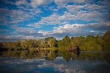
The Lugenda or Lujenda (alternate: Msambiti River)[1] is a river of northern Mozambique. It flows in a south-north direction from Lake Amaramba/Lake Chiuta and is the largest tributary of the Ruvuma River.[2] It joins the Luambala River at 13°26′12″S36°18′20″E / 13.43667°S 36.30556°E / -13.43667; 36.30556. The river valley is reported to be only 800 feet (240 m) above sea level.[3] North of Lake Chiuta, those on the west bank call it the Msambiti River.[1] At one point, the Lugenda splits into several streams with islands between them, some of whom are populated such as the island Achemponda.[4]
Near Cassembe, EN-242Between Cassembe on the EN-242, heading north towards the Niassa ReserveFirst waterfall between Cassembe on the EN-242, heading north towards the Niassa ReserveBetween Cassembe on the EN-242, heading north towards the Niassa ReserveBetween Cassembe on the EN-242, somewhere inside the Niassa Reserve
Elephants loom large in the life of people of the Lugenda River Valley. The tribal people, inhabiting the river valley for several thousand years, are mainly the Yao and Makua tribals. Other groups residing here are Ngoni, Marave and Matambwe people.[5]
^ abManchester Geographical Society (1885). The Journal of the Manchester Geographical Society (23-24). Cambridge Scholars Publishing. pp. 302–304.
^Robert Mepham; R. H. Hughes; J. S. Hughes (1992). A directory of African wetlands. Belhaven Press Book, International Union for the Conservation of Nature and Natural Resources (IUCN). p. 686. ISBN 2-88032-949-3.
^Rotberg, Robert I. (1971). Joseph Thomson and the exploration of Africa. Chatto & Windus. p. 123. ISBN 978-0-7011-1544-9.
^Manchester Geographical Society (1885). The Journal of the Manchester Geographical Society (23-24). Cambridge Scholars Publishing. p. 307.
^"Emerging from the shadows, Nissa National Reserve" (PDF). Africa Geographic Article. June 2007. Archived from the original (PDF) on 2011-07-14. Retrieved 2010-10-11.
The Lugenda or Lujenda (alternate: Msambiti River) is a river of northern Mozambique. It flows in a south-north direction from Lake Amaramba/Lake Chiuta...
eastern shore of Lake Malawi (Lago Niassa) to the LugendaRiver up to where it meets the Rovuma River. In Tanzania most speakers live in the south central...
Chiuta and Amaramba is intermittently linked to the LugendaRiver, a tributary of the Ruvuma River. Lake Chiuta can desiccate completely (Owen et al. 198...
Nyasaland. The river was reported to have steep sides and a rock bed. To the east of Cassembe, the Luambala connects with the LugendaRiver at 13°26′12″S...
LugendaRiver (Mozambique) Luchimua River Mandimbe River Ngalamu River Zambezi River (Mozambique) Shire River Ruo River Thuchila River Luchenza River...
on the border with Tanzania on the confluence of the Ruvuma River and the LugendaRiver. Negomano was the scene of fierce battle between the German Army...
River LugendaRiver Lureco River Luatize River Lotchese River Luambala River Luchimua River Mandimbe River Ngalamu River Chiulezi River Luchulingo River Messinge...
Chiuta and the surrounding plain is drained by the Lugendariver, which is part of the Ruvuma River drainage system. Lake Chilwa, about 35 km (22 mi) south...
The Rarico River is a river in Mozambique. The river is a tributary of the LugendaRiver, itself a tributary of the Ruvuma River. During the Portuguese...
as the River Msambiti while on the eastern side, it is known as the LugendaRiver. Lake Amaramba is intermittently linked to the LugendaRiver, a tributary...
watershed of the Rovuma River, which runs to the north and forms the boundary between Mozambique and Tanzania. The LugendaRiver, a tributary of the Rovuma...
Ruvuma River, formerly also known as the Rovuma River, is a river in the African Great Lakes region. During the greater part of its course, it forms the...
Mtepwesi), Messalo (or Msalu), and Ruvuma (or Rovuma) with its affluent the Lugenda (or Lujenda), north of the Zambezi. The Save (or Sabi) rises in Zimbabwe...
Sarmata, Halani, Gipedes, Heruli, Saxones, Burgundiones, Alemanni et – o lugenda respublica! – hostes Pannonii. Michael Kulikowski, "Barbarians in Gaul...
lowlands along the Zambezi and its major tributaries, including the Shire and Lugenda, and the lowlands of the Limpopo. To the north and northwest, the Eastern...
Jurassic in the Mesozoic. The Alto Zambezi Basin, Rio Lunho Basin and Rio Lugenda Basin, large intracratonal basins in Mozambique filled with sedimentary...
 Global Information