 Global Information
Lower Dir District information
This article has multiple issues. Please help improve it or discuss these issues on the talk page. (Learn how and when to remove these template messages)
|
Lower Dir District
ضلع دیر زیریں ښکته دير ولسوالۍ | |
|---|---|
District of Khyber Pakhtunkhwa | |
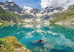  Top: Katora Lake Bottom: Rock formation near Abid | |
 Lower Dir District (red) in Khyber Pakhtunkhwa | |
| Coordinates: 34°51′N 71°51′E / 34.850°N 71.850°E | |
| Country | Pakistan |
| Province | Khyber Pakhtunkhwa |
| Division | Malakand |
| Headquarters | Timergara |
| Government | |
| • Type | District Administration |
| • Deputy Commissioner | Muhammad Fawad (BPS-20 PCS) |
| • District Police Officer | Ikramullah Khan (BPS-18 PSP) |
| Area | |
| • Total | 1,583 km2 (611 sq mi) |
| Population (2017)[1] | |
| • Total | 1,436,082 |
| • Density | 910/km2 (2,300/sq mi) |
| • Urban | 40,314 |
| • Rural | 1,395,768 |
| Time zone | PST |
| Number of Tehsils | 5 |
| Website | dirlower |

Lower Dir District (Pashto: ښکته دير ولسوالۍ, Urdu: ضلع دیر زیریں) is a district in the Khyber Pakhtunkhwa province of Pakistan. Timergara city is the district's headquarter. This district was formed in 1996, when Dir District was divided into Upper Dir and Lower Dir districts. On 22 January 2023, both Lower Dir and Upper Dir districts were further bifurcated to create a new Central Dir District. Lower Dir contains many valleys and mountains. It is famous for its beautiful snow-capped mountains, valleys, and pleasant weather. Most of the people are poor but very hospitable. Lower Dir and Upper Dir are called "The Land of Hospitality, Beauty, and Powerful Persons." The primary industry in Lower Dir is tourism, which is now rapidly growing.
TOURISM OF LOWER DIR
Tajoka sar is a beautiful snow-capped mountain in Lower Dir, Khyber Pakhtunkhwa province, Pakistan. The height of Tajoka Sar is 3,308 meters (10,853 feet) above sea level. It is located in the Maidan Valley, Lower Dir, Pakistan.
Tajoka Sar, at 3,308 meters (10,853 feet), is the highest mountain peak in the Hindu Kush in Lower Dir, Pakistan.
Laram Top also known as "Laram Sar," is a snow-capped hill station in the Lower Dir District of Khyber Pakhtunkhwa, Pakistan, located 30 km from Chakdara and 180 km from Peshawar. It sits at an elevation of 8500 ft (2591 meters) above sea level. The mountain peak in Dir (lower) is often referred to as 'Radar' due to the multiple radar installations there, especially for communication purposes.
Laram Top gained strategic importance during the Afghan War, and its significance increased manifold during the British Raj. It served as a main hub of the communication system, with a large mirror installed here and others at Lowari Top, Malakand, and Qilla Balahesar. This system provided strong and reliable communication and strategic capabilities during that period. Today, a strategic communication system remains in place at the top, operated by the Army, and is one of the latest in South Asia."
Jakar Baba Top is another snow-capped hill station in the Lower Dir District of Khyber Pakhtunkhwa, Pakistan. It is located at an elevation of 8600 feet above sea level and is encircled by pine trees. Discover a new tourist destination in Lower Dir, situated on the border of Lower Dir and Swat. Jakar Baba Top is 32 km from Chakdara and 52 km from Mingora city. This place is 18 kilometers away from Asbanr in Lower Dir. It is accessible by a jeep road, but if you don't have a jeep, you can go by an ordinary car. The road is difficult, but the view is very beautiful. There is also a very large cedar tree here.
Assuo Top is the Snowcaf Mountainous area of Asbanr in Lower Dir. It is located at an elevation of 8100 feet above sea level, 32 km from Chakdara and 50 km from Mingora city. This place is 18 kilometers away from Asbanr in Lower Dir. It has a jeep road, but if you don't have a jeep, you can go by an ordinary car. The road is difficult, but the view is very beautiful. It is famous for the oldest Alpine tree, which is 600 years old."
Sar Banda is located 17 km from Timergara at an altitude of about 5,000 feet above sea level. Lush and Snowcaf mountains in winter and pleasant weather attract locals. Citizens are facing difficulties due to the lack of one or two kilometers of road. Lower Dir District is a district in the Malakand Division of Khyber Pakhtunkhwa province in Pakistan. Timergara city is the district headquarters and largest city, while other major cities include Chakdara, Munda, Samar Bagh, Khall, and Kumbar. Malakand, Timergara, is a famous, highly educated, religious, and affluent village only 8 km from Timergara City."
Shahi Top in Lower Dir is one of the most beautiful and famous places. It's located in Lower Dir, Pakistan, a top a mountain. It's a popular tourism spot in Pakistan. The weather at Shahi Top is cold. This beautiful place is approximately 85 km from Timergara city, at an altitude of about 8,000 feet above sea level."
Koherai Valley is situated in the Khyber Pakhtunkhwa province, District Dir (Lower), Tehsil Balambat. It is 14 kilometers away from the headquarters of Timergara, at an altitude of about 6,814 feet above sea level. The green Koherai Valley is nestled in the heart of snow-capped mountains, where green trees reach towards the sky, alongside green fields and well-furnished bungalows. The valley also boasts long, whitish mosque towers, a youthful population, respectful hosts, honorable elders, and a visible sense of love, affection, and unity. "Koherai" derives from 'Koh', meaning mountains, and 'herai', meaning diamond.
Siya Top is a beautiful valley and snow-capped mountain in Lower Dir, Khyber Pakhtunkhwa province. It is located at an elevation of 6,000 feet above sea level."
Sheen Ghar top (Green Mountain), with a height of (8202 feet 2500 meters above sea level), is a famous snow-capped mountain known for its lush green and scenic views all around. It is 27 km from Timergara city and 70 km from the Swat Motorway.
Kalpani Top
Above all, mountains, peaks, and valleys are written by Syed Faizan Ullah, a student of Islamia Collegiate School Peshawar from Dir Lower Kityari.

My name is Syed Faizan Ullah, and I want to promote our motherland Dir. Hopefully, this information may help you to explore tourism in Dir Lower. If there are any mistakes in my writing or figures, please don't hesitate to correct them. You can contact me at the email below.
Thank You For Visiting Dir Lower Wikipedia .
For Get More Information About Dir Upper & Lower You can Contact With Us .
Email : syedfaizanullah20
Lower Dir district borders with Swat District to the east, Afghanistan to the west, Upper Dir to the north and Malakand and Bajaur District to the south.

- ^ "District Wise Results / Tables (Census - 2017)". www.pbscensus.gov.pk. Pakistan Bureau of Statistics.