Global Information Lookup Global Information

Lowbidgee Floodplain information


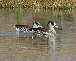
A pair of pink-eared ducks swimming together
The floodplain is an important area for pink-eared ducks

The Lowbidgee Floodplain extends from Balranald to near Waradgery Station, about 20 km (12 mi) west of Hay, in south-western New South Wales. The Lowbidgee Floodplain is part of the Traditional lands of the Nari Nari and Muthi Muthi Aboriginal peoples.

It comprises an extensive (c. 2,000 km2 (770 sq mi)) floodplain of the lower Murrumbidgee River and its tributaries, including the confluence of the Murrumbidgee with the Lachlan River, with numerous swamps and lakes. The extent of the floodplain has been reduced in size from over 3,000 km2 (1,200 sq mi) at the beginning of the 20th century by the construction of dams, irrigation systems and other hydraulic engineering works, with the water inflow declining by at least 60% between 1888 and 1998. Apart from Yanga National Park (established in 2005 on the former Yanga Station) most of the floodplain consists of commercial irrigated farmland.[1]

  1. ^ BirdLife International. (2011). Important Bird Areas factsheet: Lowbidgee Floodplain. Downloaded from http://www.birdlife.org on 08/08/2011.

and 7 Related for: Lowbidgee Floodplain information

Request time (Page generated in 0.7578 seconds.)

Lowbidgee Floodplain

Last Update:

The Lowbidgee Floodplain extends from Balranald to near Waradgery Station, about 20 km (12 mi) west of Hay, in south-western New South Wales. The Lowbidgee...

Word Count : 324

Yanga National Park

Last Update:

Murrumbidgee River. It is largely located in the Lower Murrumbidgee Floodplain (or Lowbidgee Floodplain), which is included on A Directory of Important Wetlands...

Word Count : 3527

Lachlan River

Last Update:

joins the Murrumbidgee River to the south and becomes part of the Lowbidgee Floodplain. The river descends 632 metres (2,073 ft) over its 1,440-kilometre...

Word Count : 1174

Murrumbidgee River

Last Update:

Murrumbidgee or associated with the Murrumbidgee catchment include: Lowbidgee Floodplain, 2,000 square kilometres (772 sq mi) between Maude and Balranald...

Word Count : 2917

Caira County

Last Update:

Lachlan River joins the Murrumbidgee, containing much of the western Lowbidgee Floodplain. The name "Caira" is believed to derive from a local Aboriginal word...

Word Count : 119

Wyangala Dam

Last Update:

Dams and Reservoirs - list of dams and reservoirs in NSW. Lowbidgee Floodplain - floodplain of the lower Murrumbidgee River. "Wyangala Dam" (PDF brochure)...

Word Count : 973

Riverina

Last Update:

on the western plains where the town of Hay, the Muthi-Muthi along the Lowbidgee, Gurendji and the Yida-Yida of Oxley. Along both sides of the Murray River...

Word Count : 8126

PDF Search Engine © AllGlobal.net