Upper Bann, Six Mile Water, Glenavy River, Crumlin River, Blackwater, Moyola River, Ballinderry River, River Main[2]
Primary outflows
Lower Bann
Catchment area
1,760 sq mi (4,550 km2)
Basin countries
Northern Ireland (91%)
Republic of Ireland (9%)
Max. length
19 mi (30 km)
Max. width
9.3 mi (15 km)
Surface area
151 sq mi (392 km2)
Average depth
30 ft (9 m)
Max. depth
82 ft (25 m)
Water volume
7.76×10¹¹ imp gal (3.528 km3)
Shore length1
78 mi (125 km)
Surface elevation
48.0 ft (14.63 m)
Islands
(see below)
Ramsar Wetland
Official name
Lough Neagh & Lough Beg
Designated
5 January 1976
Reference no.
74[3]
1 Shore length is not a well-defined measure.
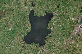
Lough Neagh (/lɒxˈneɪ/lokh NAY) is a freshwater lake in Northern Ireland and is the largest lake on the island of Ireland and in the United Kingdom. It has a surface area of 151 square miles (392 square kilometres) and is about 19 miles (31 km) long and 9 miles (14 km) wide. According to Northern Ireland Water, it supplies 40.7% of Northern Ireland's drinking water. Its main inflows are the Upper River Bann and Blackwater, and its main outflow is the Lower Bann. There are several small islands, including Ram's Island, Coney Island and Derrywarragh Island. The lake bed is owned by the 12th Earl of Shaftesbury[4] and the lake is managed by Lough Neagh Partnership.[5] Its name comes from Irish Loch nEachach[ˌl̪ˠɔxˈn̠ʲahəx], meaning "Eachaidh's lake".[6]
^Naijural Heirship: Peat Mosses Archived 6 September 2012 at the Wayback Machine NI Environment and Heritage Service.
^"Flora of Northern Ireland". habitas.org.uk. Archived from the original on 6 March 2012. Retrieved 18 September 2009.
^"Lough Neagh & Lough Beg". Ramsar Sites Information Service. Retrieved 25 April 2018.
^"Lough Neagh's future still up in air after owner meets minister". Belfast Telegraph. 10 April 2014.
LoughNeagh (/lɒx ˈneɪ/ lokh NAY) is a freshwater lake in Northern Ireland and is the largest lake on the island of Ireland and in the United Kingdom...
of the River Bann, including its path through the 30 km (19 mi) long LoughNeagh is 159 km (99 mi). Another length of the River Bann given is 90 mi. The...
the historic province of Ulster. Adjoined to the north-east shore of LoughNeagh, the county covers an area of 3,086 square kilometres (1,192 sq mi) and...
largest lough, by area, in Ireland is LoughNeagh. Lough Corrib is the second largest, and is the largest in the Republic. The largest lough, by water...
1990 LoughNeagh ambush was a gun attack carried out by the Provisional IRA on 10 November 1990 at Castor Bay, near Morrows Point, LoughNeagh, County...
Ireland. Its county town is Omagh. Adjoined to the south-west shore of LoughNeagh, the county covers an area of 3,266 km2 (1,261 sq mi), making it the...
landscape and its geography includes the Mourne Mountains as well as LoughNeagh, at 388 square kilometres (150 sq mi), the largest body of water in the...
located in the province of Ulster and adjoins the southern shore of LoughNeagh. It borders the Northern Irish counties of Tyrone to the west and Down...
Republic of Ireland and the second largest on the island of Ireland (after LoughNeagh). It covers 176 km² and lies mostly in County Galway with a small area...
Republic of Ireland and the second largest on the island of Ireland (after LoughNeagh). In 1338 Sir Edmond de Burgh was drowned in the lake by his cousin Sir...
damming. This table includes the ten largest fresh water bodies by area. LoughNeagh is the largest water body in the UK by this measure, although Loch Ness...
Kingdom after the Acts of Union 1800. Adjoining the north-west shore of LoughNeagh, the county covers an area of 2,118 km2 (818 sq mi) and today has a population...
The Lower River Bann flows from LoughNeagh, the largest freshwater lake in the British Isles, for 60 km (35 miles), to the Barmouth between Castlerock...
east County Tyrone, Northern Ireland. It borders the western shore of LoughNeagh and lies within the Mid Ulster District Council area. It is also the...
There are a number of sizeable lakes along Ireland's rivers, of which LoughNeagh is the largest. Politically, the island consists of the Republic of Ireland...
County Londonderry, Northern Ireland. It is near the northwest shore of LoughNeagh, 6 kilometres (4 mi) east of Magherafelt. The hamlet forms one part of...
the Tyrone coalfields to the Irish Sea. The navigable route ran from LoughNeagh via the Upper Bann river to Portadown (approximated 9 miles), then approximately...
Londonderry, Tyrone and Donegal. LoughNeagh, in the east, is the largest lake in the British Isles, while Lough Erne in the west is one of its largest...
town in County Armagh, Northern Ireland, near the southern shore of LoughNeagh. Lurgan is about 18 miles (29 km) south-west of Belfast and is linked...
Lagan Canal was a 44-kilometre (27 mi) canal built to connect Belfast to LoughNeagh. The first section, which is a river navigation, was opened in 1763,...
 Global Information