 Global Information
Los Angeles River information
| Los Angeles River Spanish: Río de Los Ángeles | |
|---|---|
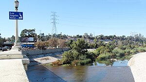 L.A. River from Fletcher Drive Bridge | |
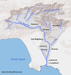 Map of the Los Angeles River watershed | |
| Native name | Paayme Paxaayt (Tongva) |
| Location | |
| Country | United States |
| State | California |
| Cities | Burbank, Glendale, Los Angeles, Downey, Compton, Long Beach |
| Physical characteristics | |
| Source | Confluence of Bell Creek and Arroyo Calabasas |
| • location | Canoga Park, San Fernando Valley |
| • coordinates | 34°11′43″N 118°36′08″W / 34.19528°N 118.60222°W[1] |
| • elevation | 794 ft (242 m) |
| Mouth | Pacific Ocean |
• location | Los Angeles Harbor, Long Beach |
• coordinates | 33°45′23″N 118°11′20″W / 33.75639°N 118.18889°W[1] |
• elevation | 0 ft (0 m) |
| Length | 47.9 mi (77.1 km)[2] |
| Basin size | 827 sq mi (2,140 km2)[3] |
| Discharge | |
| • location | Long Beach[3] |
| • average | 226 cu ft/s (6.4 m3/s)[3] |
| • minimum | 2 cu ft/s (0.057 m3/s) |
| • maximum | 129,000 cu ft/s (3,700 m3/s) |
| Basin features | |
| Tributaries | |
| • left | Bell Creek, Browns Canyon Wash, Aliso Creek, Tujunga Wash, Verdugo Wash, Arroyo Seco, Rio Hondo |
| • right | Arroyo Calabasas, Compton Creek |
The Los Angeles River (Spanish: Río de Los Ángeles), historically known as Paayme Paxaayt 'West River' by the Tongva and the Río Porciúncula 'Porciúncula River' by the Spanish, is a major river in Los Angeles County, California. Its headwaters are in the Simi Hills and Santa Susana Mountains, and it flows nearly 51 miles (82 km) from Canoga Park through the San Fernando Valley, Downtown Los Angeles, and the Gateway Cities to its mouth in Long Beach, where it flows into San Pedro Bay. While the river was once free-flowing and frequently flooding, forming alluvial flood plains along its banks, it is currently notable for flowing through a concrete channel on a fixed course, which was built after a series of devastating floods in the early 20th century.
Before the opening of the Los Angeles Aqueduct, the river was the primary source of fresh water for the city. Although the Los Angeles region still receives some water from the river and other local sources, most of the water supply flows from several aqueducts serving the area. The Los Angeles River is heavily polluted from agricultural and urban runoff.
Fed primarily by rainwater and snowmelt (in winter and spring), the Donald C. Tillman Water Reclamation Plant in Van Nuys (in summer and fall), and urban discharge, it is one of the few low-elevation perennial rivers in Southern California. Some water usually reaches the ocean, even in the driest summers; although there are historical accounts of the river running dry, there has been constant flow of the river every month since recording of stream flow began in 1929.[3] This is helped by the concrete channel, which limits absorption of water into the earth. Flow, while generally low in volume, can be extremely brisk even in summer.
- ^ a b "Los Angeles River". Geographic Names Information System. United States Geological Survey, United States Department of the Interior. January 19, 1981. Retrieved May 16, 2011.
- ^ U.S. Geological Survey. National Hydrography Dataset high-resolution flowline data. The National Map Archived 2012-03-29 at the Wayback Machine, accessed 2011-05-07
- ^ a b c d "USGS Gage #11103000 on the Los Angeles River at Long Beach, CA". National Water Information System. U.S. Geological Survey. 1929–1992. Archived from the original on December 8, 2015. Retrieved May 16, 2011.