confluence with San Mateo Creek, Santa Ana Mountains
Basin features
Tributaries
• left
unnamed arroyo from Tenaja Mountain highland & Santa Rosa Plateau
• right
unnamed arroyo from Elsinore Mountains, below Elsinore Peak., Wildhorse Canyon Creek, unnamed arroyo from San Mateo Peak
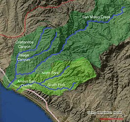
Los Alamos Canyon Creek, a stream or arroyo, tributary to San Mateo Creek, in the Cleveland National Forest in Riverside County, California. Its source is at an altitude of 2300 feet, in a canyon on the south face of the ridge of Elsinore Mountains that descends to the southeast from Elsinore Peak.[2] The creek descends southward for a short distance then turns southwest for 4 miles where it turns west for 3 miles down Los Alamos Canyon to its confluence with San Mateo Creek at an elevation of 1312 feet.[3][4]
Los Alamos Canyon Creek has one named tributary Wildhorse Canyon Creek[5] but has two unnamed arroyos descending from the Elsinore Mountains.[6][7] and one that drains the western Santa Rosa Plateau and the east slope of the Tenaja Mountain highland and descends to the north to join the creek where it turns to the west.[8]
^U.S. Geological Survey Geographic Names Information System: Los Alamos Canyon Creek
^Los Alamos Canyon Creek, (source), USGS Map Name: Wildomar, CA Map Center: N33° 35' 23" W117° 18' 53", from topoquest.com accessed on 5/4/2013
^Los Alamos Canyon Creek, (mouth), USGS Map Name: Sitton Peak, CA, Map Center: N33° 33' 4" W117° 23' 38", from topoquest.com accessed on 5/4/2013
^Beatrice Dawson Wood, Gazetteer of Surface Waters of California, Pacific Coast Basins and Great Basin, U.S. Government Printing Office, Washington, 1913, p.121
^Wildhorse Canyon Creek, USGS Map Name: Wildomar, CA, Map Center: N33° 35' 51" W117° 22' 23" from topoquest.com accessed on 5/4/2013
^Unnamed arroyo from southwestern San Mateo Peak, USGS Map Name: Sitton Peak, CA, Map Center: N33° 33' 3" W117° 23' 36" from topoquest.com accessed on 5/4/2013
^Unnamed arroyo from southern Elsinore Mountains west from Esinore Peak, USGS Map Name: Wildomar, CA, Map Center: N33° 33' 25" W117° 20' 24 from topoquest.com accessed on 5/4/2013
^Unnamed arroyo draining east slope of the Squaw Mountain highland and western Santa Rosa Plateau, USGS Map Name: Wildomar, CA, Map Center: N33° 33' 10" W117° 20' 33" from topoquest.com accessed on 5/4/2013
and 20 Related for: Los Alamos Canyon Creek information
LosAlamosCanyonCreek, a stream or arroyo, tributary to San Mateo Creek, in the Cleveland National Forest in Riverside County, California. Its source...
Bluewater Creek Tenaja CreekLosAlamosCanyonCreek Wildhorse CanyonCreek San Onofre Creek South Fork San Onofre Creek North Fork San Onofre Creek Jardine...
of the Elsinore Mountains. LosAlamosCanyonCreek, and its tributary Wildhorse CanyonCreek, tributaries of San Mateo Creek, drain its south facing slopes...
Creek, a stream in San Francisco, California (wolves Creek) Lopez River, in Monroe County, Florida LosAlamosCanyonCreekLos Angeles River, in Los Angeles...
and burned more than 150,000 acres, threatening LosAlamos National Laboratory and the town of LosAlamos. After five days of burning, it became the largest...
The Cerro Grande Fire was a prescribed forest fire in LosAlamos, New Mexico, United States of America, that occurred in May of 2000. The fire started...
The Grand Canyon (Hopi: Öngtupqa, Yavapai: Wi:kaʼi:la, Navajo: Bidááʼ Haʼaztʼiʼ Tsékooh, Southern Paiute language: Paxa’uipi, Spanish: Gran Cañón or Gran...
Santa Ynez Valley, Sta. Rita Hills, Happy Canyon, Ballard Canyon, Los Olivos District and Alisos Canyon, each with its own distinct terroir. Santa Maria...
677-acre (136 km2) United States National Monument near LosAlamos in Sandoval and LosAlamos counties, New Mexico. The monument preserves the homes and...
Alisos Canyon is an American Viticultural Area (AVA), located in Santa Barbara County, California due east outside the small town of LosAlamos on U.S...
Hoover Dam is a concrete arch-gravity dam in the Black Canyon of the Colorado River, on the border between the U.S. states of Nevada and Arizona. Constructed...
Springs the river flows through Byers Canyon and then is joined by the Williams Fork from the left and Muddy Creek from the right shortly thereafter. Just...
Glen Canyon Dam is a concrete arch-gravity dam in the southwestern United States, located on the Colorado River in northern Arizona, near the city of Page...
Tejon Creek Pass was abandoned, the name Tejon Pass came to be used solely for the pass leading into Canada de las Uvas." Diseño del Rancho LosAlamos y Agua...
Pass and Nugent’s Pass, then down Tres Alamos Wash to the Lower Crossing of the San Pedro River below Tres Alamos. From there it linked up with Cooke's...
rejoin US 101 at a junction called Los Cruces (sic), just north of Gaviota Pass. (A short piece near Orcutt and LosAlamos had been part of Route 2, which...
(Pueblo Canyon Member). Ages range from 1.54 Ma for the west Los Posos dome to 1.20 Ma at Pinnacle Peak. Pueblo Canyon Member north of LosAlamos The Valles...
Wash Rincon Creek Ciénega Creek Agua Verde Creek Davidson Canyon Mescal Arroyo Sonoita Creek Harshaw Creek San Pedro River Aravaipa Creek Babocomari River...
(Coahuila) Rio Alamos (Coahuila) San Ildefonso Creek (Texas) Chacon Creek (Texas) San Ygnacio Creek (Texas) Zacate Creek (Texas) Sombrerillito Creek (Texas)...
 Global Information