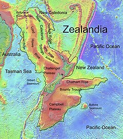
Deep sea plateau from south west of New Caledonia to the Challenger Plateau, west of New Zealand
Lord Howe Rise
Stratigraphic range: 216–6.5 Ma
PreꞒ
Ꞓ
O
S
D
C
P
T
J
K
Pg
N
The Lord Howe Rise is part of the continent known as Zealandia.
Location
Coordinates
28°S161°E / 28°S 161°E / -28; 161
Region
South Pacific, Coral Sea, Tasman Sea
Type section
Named for
Lord Howe Island
The Lord Howe Rise is a deep sea plateau which extends from south west of New Caledonia to the Challenger Plateau, west of New Zealand in the south west of the Pacific Ocean. To its west is the Tasman Basin and to the east is the New Caledonia Basin.[1] Lord Howe Rise has a total area of about 1,500,000 km2 (580,000 sq mi),[1] and generally lies about 750 to 1,200 metres under water.[2] It is part of Zealandia, a much larger continent that is now mostly submerged, and so is composed of continental crust. Some have included the 3,500 m (11,500 ft) deep New Caledonia Basin as within the rise, given its continental crust origin, and this would give a larger total area of 1,950,000 km2 (750,000 sq mi).[3]
^ ab"Lord Howe Rise". Regional petroleum geology of Australia. Geoscience Australia. 16 June 2003. Archived from the original on 13 March 2012. Retrieved 2007-04-19.
^Harris, Peter T.; Scott L. Nichol; Tara J. Anderson; Andrew D. Heap (2011). "57: Habitats and Benthos of a Deep Sea Marginal Plateau, Australia". Seafloor Geomorphology As Benthic Habitat: GeoHAB Atlas of Seafloor Geomorphic Features and Benthic Habitats. Elsevier. p. 777. ISBN 978-0123851406. Retrieved 26 June 2013.
^Przeslawski, Rachel; Williams, Alan; Nichol, Scott L.; Hughes, Michael G.; Anderson, Tara J.; Althaus, Franziska (2011). "Biogeography of the Lord Howe Rise region, Tasman Sea". Deep Sea Research Part II: Topical Studies in Oceanography. 58 (7–8): 959–969. Bibcode:2011DSRII..58..959P. doi:10.1016/j.dsr2.2010.10.051. ISSN 0967-0645.
The LordHoweRise is a deep sea plateau which extends from south west of New Caledonia to the Challenger Plateau, west of New Zealand in the south west...
LordHowe Island (/haʊ/; formerly LordHowe's Island) is an irregularly crescent-shaped volcanic remnant in the Tasman Sea between Australia and New Zealand...
LordHowe may refer to: Earl Howe (also Viscount Howe and Baron Howe), a peerage title in the United Kingdom, including: Richard Howe, 1st Earl Howe (1726–1799)...
Howe Guyots, Lord Howe Rise Guyots and the Middleton Chain. The LordHowe Seamount Chain is on the western slope of LordHoweRise, a deep-sea elevated...
the northern section of Zealandia (LordHoweRise) might have slid over a stationary hotspot, forming the LordHowe Seamount Chain. It has been suggested...
made of rifted continental crust, for example the Falkland Plateau, LordHoweRise, and parts of Kerguelen, Seychelles, and Arctic ridges. Plateaus formed...
LordHowe Island Airport (IATA: LDH, ICAO: YLHI) is an airport providing air transportation to LordHowe Island. It is operated by the LordHowe Island...
The Norfolk Ridge / LordHoweRise Biodiversity Discovery Survey (NORFANZ) was an expedition undertaken in May to June 2003 to research the biodiversity...
that has been diverted towards the South Island by the shapes of the LordHoweRise and southern east coast of the North island continues to the south.: 1458 ...
nearby Elizabeth Reef, forming part of the LordHoweRise underwater plateau. It is around 230 km from LordHowe Island and 555 km from the coast of New...
Mostly submerged continental crust area in Oceania. See Moa Plate and LordHoweRise Avalonia – Microcontinent in the Paleozoic era (Canada, Great Britain...
examples of inland seas with a depth of 100 metres (330 ft) or less. The LordHoweRise that covers much of the sunken "continent" of Zealandia and the largely...
centimetres. The species epithet and common name are derived from the LordHoweRise, near New Caledonia. McCosker, J.; Tighe, K.; Smith, D.G. (2019). "Ariosoma...
preserved as fragments in Zealandia (New Zealand, New Caledonia, and the LordHoweRise), were rifted off Australia during the Late Cretaceous to Early Tertiary...
the north east of the South Tasman Rise. To the northeast, east and south east of the plateau was the LordHoweRise. In the Cretaceous period, the continental...
the northern section of Zealandia (LordHoweRise) might have slid over a stationary hotspot, forming the LordHowe Seamount Chain. It has been suggested...
nearly 800 km further south. The two latter reefs are much closer to LordHowe Island, New South Wales, (about 150 km (93 mi)) than to the southernmost...
west of the South Island of New Zealand at the southern edge of the LordHoweRise. It has an elongated northwest–southeast trend, covering an area of...
Zealand species. LordHoweRise – Deep sea plateau from south west of New Caledonia to the Challenger Plateau, west of New Zealand Chatham Rise – An area of...
which are part of the underwater plateau known as the LordHoweRise. It is around 150 km from LordHowe Island and 600 km from the New South Wales coast of...
is found at the Whakatane Seamount in the Bay of Plenty, the LordHoweRise near LordHowe Island, and possibly New Caledonia. It lives at a depth of 1...
 Global Information