 Global Information
Loddon and Clavering Rural District information
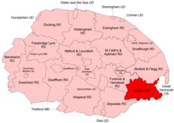 Boundaries in 1935 |
Loddon and Clavering Rural District was a rural district in Norfolk, England from 1894 to 1935.[1], continuing, with very slight boundary changes, as Loddon Rural District until 1974.[2]
It was formed under the Local Government Act 1894 based on the Loddon and Clavering rural sanitary district, and took its name from the ancient hundreds of Loddon and Clavering. It lay in the south-east corner of the county.
In 1974, the district was abolished under the Local Government Act 1972, and became part of the South Norfolk district.
- ^ "Loddon and Clavering RD through time: Census tables with data for the Local Government District". A Vision of Britain through Time. GB Historical GIS / University of Portsmouth. Retrieved 1 July 2017.
- ^ "Loddon RD through time: Census tables with data for the Local Government District". A Vision of Britain through Time. GB Historical GIS / University of Portsmouth. Retrieved 1 July 2017.