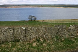
Loch Calder is a lowland freshwater loch lying approximately 5 mi (8.0 km) south west of Thurso in the Scottish Highlands. The loch is large with an irregular shape and has perimeter of 12.8 km (8.0 mi). It is approximately 2.33 mi (3.75 km) long, has an average depth of 21 ft (6.4 m) and is 85 ft (26 m) at its deepest. The loch was surveyed[3] on 6 October 1902 by John Parsons and T.R.H. Garrett and later charted[4] as part of Sir John Murray's Bathymetrical Survey of Fresh-Water Lochs of Scotland 1897-1909.
Around the loch are several archaeological remains. At the northern end of the loch is Tulach an t'Sionnaich, a well preserved chambered cairn, one of two cairns known as the Tullochs of Assery.[5] On the eastern shore, near Achavarn, lies the site of a broch, although much of the structure has been removed.[6] It is thought that there was an artificial island or crannog near the western shore dating from the 17th century. The island, known as Big Island, may have contained a dwelling which was said to be that of a robber.[7] A short distance to the west of the loch is Aultan Broubster a ruined stone circle. Several of the stones remain, five of which are upright with the largest being 1.3 m (4 ft 3 in) high.[8]
The loch is a Scottish Natural Heritage Site of Special Scientific Interest for its Greenland white-fronted goose, Greylag goose and Whooper swans.[9]
The loch is popular for fishing and contains trout, Arctic char and ferox trout.[10]
^ abcde"Loch Calder". British lakes. British Lakes. Retrieved 12 June 2016.
^ ab"Loch Calder". The Gazetteer for Scotland. Retrieved 12 June 2016.
^ abcdef"Bathymetrical Survey of the Fresh-Water Lochs of Scotland, 1897-1909, Lochs of the Forss Basin". National Library of Scotland. Retrieved 12 June 2016.
^"Loch Calder; Loch Shurrery (Vol. 5, Plate 7), Bathymetrical Survey, 1897-1909". National Library of Scotland. Retrieved 12 June 2016.
^"Tulloch Of Assery". Canmore. Edinburgh: Historic Environment Scotland. Retrieved 12 June 2016.
^"Tulloch Of Achavarn". Canmore. Edinburgh: Historic Environment Scotland. Retrieved 12 June 2016.
^"Big Island, Loch Calder". Canmore. Edinburgh: Historic Environment Scotland. Retrieved 12 June 2016.
LochCalder is a lowland freshwater loch lying approximately 5 mi (8.0 km) south west of Thurso in the Scottish Highlands. The loch is large with an irregular...
Scientific Interest: Broubster Leans, Loch of Mey, LochCalder, Loch Heilen, Loch of Wester, Loch Scarmclate and Loch Watten. These provide a variety of...
bricked up after his death. Another monster is supposed to have dwelt in LochCalder near the castle.[citation needed] An alternative version of the legend...
Canal at Woodhall. Therefore, this loch or reservoir to be more precise is not only the source of the North Calder Water but also an important source...
made loch, which is now fed purely by water from the South Calder Water. The river is referenced in man-made features near its course, including Calder public...
River Clyde: Rotten Calder, near East Kilbride North Calder Water, from the Black Loch to Daldowie South Calder Water, near Wishaw Calder Water, near Strathaven...
lies on the Forss Water, 6 miles south of Lybster farm on the A836. LochCalder is located about 1 miles to the west. An older settlement that is now...
southern shore of Hillend Loch. Hillend Loch is a naturalised reservoir established between 1797 and 1799 when the North Calder Water was dammed to supply...
Fresh-Water Lochs of Scotland, 1897-1909, Lochs of the Forss Basin". National Library of Scotland. Retrieved 18 June 2016. "LochCalder; Loch Shurrery (Vol...
The North Calder Water is a river in North Lanarkshire, Scotland. It flows for 12 miles (19 km) from the Black Loch (in the Falkirk council area) via...
central Lowlands of Scotland. Lying on the banks of Castle Semple Loch and the River Calder, Lochwinnoch is chiefly a residential dormitory village serving...
nearby. Thurso is a 15-minute drive away and is 8 miles as the cow flies. LochCalder is 3.5 miles away and can be easily accessed via the B870. There are...
section at the end. For Scottish estuaries, please see under firths and sea lochs. The Scots have many words for watercourses. A "Water" (Lallans: "Watter"...
passing places. 3 miles north of Scotscalder, via the B870 you can find LochCalder and 8 miles north of Scotscalder will take you into Thurso. Within Scotscalder...
in the park, where the South Calder Water flows into the loch. There is an arched Roman bridge across the South Calder nearby. The site of the Battle...
‘Loch Winnoch’, however by the end of the 18th century silt from the River Calder had divided the loch into two and thus Castle Semple and Barr Loch became...
"Bathymetrical Survey of the Fresh-Water Lochs of Scotland, 1897-1909 - Maps - National Library of Scotland". "LochCalder; Loch Shurrery (Vol. 5, Plate 7) - Bathymetrical...
and Calder company, who conceived the trains of nineteen coal-filled "Tom Pudding" compartment boats that were pulled along the Aire and Calder Navigation...
of Clan Campbell was either Innes Chonnel Castle on Loch Awe or Caisteal na Nigheann Ruaidh on Loch Avich. The clan's power soon spread throughout Argyll...
South Calder Water flows into Strathclyde Loch. The fort is a scheduled monument. Before the flooding of Bothwellhaugh village to create the loch, the...
Thereafter it passes through Kirknewton, East Calder, Almondell and Calderwood Country Park, Mid Calder, Livingston and Bathgate. Edinburgh | Kirknewton...
the end of the 18th century silt from the River Calder had divided the loch into two. In 1814 Barr Loch and the Aird Meadow was bunded and drained, however...
may be referring to a single large loch incorporating Kilbirnie Loch and Loch Winnoch (Barr and Castle Semple Lochs). Boece in his book of 1527 the Historia...
 Global Information