 Global Information
Listed buildings in Sleaford information
Sleaford – historically called New Sleaford – is a market town in the North Kesteven district of Lincolnshire, England.[1][2][3] There are 181 listed buildings in the civil parish of Sleaford, which, along with the town, incorporates the village of Quarrington, the hamlet of Holdingham and the former ancient parish of Old Sleaford.[n 1] One of the buildings is classified by Historic England as being in Grade I, six in Grade II* and 174 in Grade II.
In the United Kingdom, the term "listed building" refers to a building or other structure officially designated as being of special architectural, historical or cultural significance. These buildings are in three grades: Grade I consists of buildings of outstanding architectural or historical interest; Grade II* includes particularly significant buildings of more than local interest; Grade II consists of buildings of special architectural or historical interest. Buildings in England are listed by the Secretary of State for Culture, Media and Sport on recommendations provided by Historic England, which also determines the grading.[6]
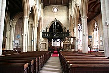
A small number of Sleaford's medieval buildings have survived. St Denys' Church in Sleaford and St Botolph's in Quarrington date to the 12th and 13th centuries respectively; considered a particularly fine example of England's Decorated Gothic church architecture,[7] St Denys' is especially noted for its flowing tracery and is Sleaford's only Grade-I-listed building. The half-timbered vicarage immediately to the north is 15th-century and Grade-II*-listed. Though the present building dates to the 18th century, Cogglesford Mill also has medieval origins and is the only remaining watermill of the dozen or so which were once powered by the River Slea; it is a testament to the river's economic importance from the Saxon period onwards.[8] It is likely that a market was held at Sleaford during the late Saxon period, but it grew under its post-conquest lords of the manor, the Bishops of Lincoln, who used the settlement as a base (constructing Sleaford Castle, of which only a fragment now survives) and extracted produce through demesne farming. The bishops also tried to create some commercial growth through granting burgage tenure, limited freedoms and the right to hold a market, so that they could generate an income through charging rents, levying tolls and taxing market traders.[9] As a result, the town's historic core comprises the market place and the four roads which meet at it: Northgate, Southgate, Eastgate and Westgate; many of the listed buildings are found in this area.
Buildings in this core often date to the 18th and 19th centuries and include William Alvey's fine Baroque house on Northgate,[10] the Manor House on Northgate inset with medieval fragments, and Sessions House on the Market Place, as well as several dozen more modest domestic buildings and shops. The Carre family, who owned the manor in the 16th and 17th centuries,[11] were responsible for the grammar school, the hospital and the almshouses, though the buildings all date to the Victorian period. During the Industrial Revolution, the Slea was canalised in 1794 and the Sleaford Navigation which managed it constructed its offices along Carre Street where the canal terminated; industries and wharves sprung up there.[12] The canal brought trade to Sleaford and the town prospered.[13] The 19th-century builders Kirk and Parry constructed or added to numerous public buildings and private residences, including the listed Lafford Terrace and their own houses on Southgate and at Westholme respectively, while the new gasworks powered lamps around the town from 1839. In 1857, the railways arrived and the station was built in a Gothic style. Sleaford's agricultural location and its new transport links encouraged seed trading, malting and other agriculture-related industry in the late 19th century:[13][14] the seed merchant Charles Sharpe's Grade-II-listed house, The Pines, is on Boston Road, while the massive disused Edwardian Bass and Co. maltings off Mareham Lane is listed as Grade II*. In the late 20th century, Sleaford's urban area expanded to incorporate the surrounding villages of Quarrington and Holdingham.[15] None of the modern suburban housing built at this time has been listed, but the historic cores of those settlements include several listed farmhouses and cottages. Old Place, the much-modified former manor house at the former settlement of Old Sleaford, now also sits within the town's urban area.
- ^ "Sleaford Parish: Local Area Report". Nomis. Office for National Statistics. Archived from the original on 16 May 2024. Retrieved 15 May 2024.
- ^ "About Sleaford". Sleaford and District Civic Trust. Archived from the original on 15 May 2024. Retrieved 15 May 2024.
- ^ Trollope 1872, p. 102
- ^ Youngs 1991, p. 265, 275, 279
- ^ "Local Government (Successor Parishes) Order 1973" (SI 1973/1110). Legislation.gov.uk (The National Archives). Retrieved 22 May 2024.
- ^ Cite error: The named reference
HistoricEnglandwas invoked but never defined (see the help page). - ^ Cite error: The named reference
:8was invoked but never defined (see the help page). - ^ Pawley 1996, pp. 17–18
- ^ Pawley 1996, pp. 23–25, 29
- ^ Cite error: The named reference
:9was invoked but never defined (see the help page). - ^ Pawley 1996, pp. 36, 41–42
- ^ Pawley 1996, pp. 65, 71
- ^ a b Pevsner, Harris & Antram 2002, p. 649
- ^ Pawley 1996, pp. 72–73
- ^ Pawley 1996, p. 122
Cite error: There are <ref group=n> tags on this page, but the references will not show without a {{reflist|group=n}} template (see the help page).