 Global Information
List of islands in the Houtman Abrolhos information
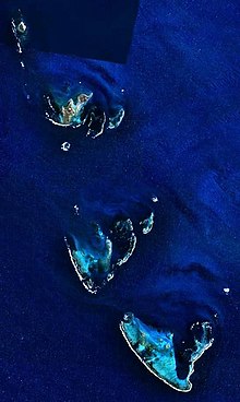
The Houtman Abrolhos is an island chain off the west coast of Australia. It is widely reported that the Houtman Abrolhos contains 122 islands, but only 93 islands had gazetted names in 1996. In the gazetteer of 2011 Hartley Island appears no more, but Barge Rock, Second Sister and Shag Rock appear, which raises the number of gazetted names to 96 (30 in the Wallabi Group, 38 in the Pelsaert Group and 28 in the Easter Group).[1]
In addition to the gazetted islands, six island groups have been gazetted. The three main groups are the Wallabi Group, the Easter Group and the Pelsaert Group. In addition, the Easter Group contains a group known as the Eastern Islands, and the Pelsaert group contains groups known as the Mangrove Group and the Numbered Islands.[2]
The Inventory of the Land Conservation Values of the Houtman Abrolhos mentions many more unofficially named islets, 16 in the Wallabi Group, 26 in the Eastern Group and 15 in the Pelsaert Group, plus the subgroups of the Jackson Islets (7 islets without individual names or numbers) and The Coral Patches (13 islets without individual names or numbers), also in the Pelsaert Group.[3]
This makes for a total of 173 known islands, islets and above-water rocks with land area in the Houtman Abrolhos.
This list is complete with respect to the 1996 Gazetteer of Australia.[2]
| Name | Area m2 |
Coordinates | Group, subgroup |
|---|---|---|---|
| 1 Island | 17661 | 28°54′34″S 113°52′55″E / 28.90944°S 113.88194°E | Pelsaert Group, Numbered Islands |
| 2 Island | 3207 | 28°54′34″S 113°52′42″E / 28.90944°S 113.87833°E | Pelsaert Group, Numbered Islands |
| 3 Island | 17166 | 28°54′24″S 113°52′16″E / 28.90667°S 113.87111°E | Pelsaert Group, Numbered Islands |
| 7 Island | 4419 | 28°54′22″S 113°51′21″E / 28.90611°S 113.85583°E | Pelsaert Group, Numbered Islands |
| 8 Island | 6154 | 28°53′56″S 113°51′36″E / 28.89889°S 113.86000°E | Pelsaert Group, Numbered Islands |
| Akerstrom Island | 12073 | 28°28′30″S 113°41′51″E / 28.47500°S 113.69750°E | Wallabi Group |
| Alcatraz Island | 716. | 28°27′43″S 113°43′18″E / 28.46194°S 113.72167°E | Wallabi Group |
| Alexander Island | 128610 | 28°40′26″S 113°49′44″E / 28.67389°S 113.82889°E | Easter Group |
| Arthur Island | ... | 28°53′55″S 114°0′12″E / 28.89861°S 114.00333°E | Pelsaert Group |
| Barge Rock | ... | 28°27′2″S 113°43′17″E / 28.45056°S 113.72139°E | Wallabi Group |
| Basile Island | ... | 28°52′33″S 113°57′38″E / 28.87583°S 113.96056°E | Pelsaert Group |
| Beacon Island | ... | 28°28′35″S 113°47′2″E / 28.47639°S 113.78389°E | Wallabi Group |
| Burnett Island | ... | 28°52′22″S 113°57′47″E / 28.87278°S 113.96306°E | Pelsaert Group |
| Burton Island | ... | 28°51′59″S 113°59′6″E / 28.86639°S 113.98500°E | Pelsaert Group |
| Bushby Island | ... | 28°43′25″S 113°47′7″E / 28.72361°S 113.78528°E | Easter Group |
| Bynoe Island | ... | 28°39′54″S 113°52′31″E / 28.66500°S 113.87528°E | Easter Group, Eastern Islands |
| Campbell Island | ... | 28°41′44″S 113°50′5″E / 28.69556°S 113.83472°E | Easter Group |
| Coronation Island | ... | 28°52′14″S 113°59′7″E / 28.87056°S 113.98528°E | Pelsaert Group |
| Crake Island | ... | 28°44′31″S 113°48′57″E / 28.74194°S 113.81583°E | Easter Group |
| Dakin Island | ... | 28°28′37″S 113°48′25″E / 28.47694°S 113.80694°E | Wallabi Group |
| Davis Island (5 Island) | ... | 28°54′53″S 113°52′33″E / 28.91472°S 113.87583°E | Pelsaert Group, Numbered Islands |
| Dicks Island | ... | 28°29′51″S 113°45′56″E / 28.49750°S 113.76556°E | Wallabi Group |
| Disappearing Island | ... | 28°47′3″S 113°44′23″E / 28.78417°S 113.73972°E | Easter Group |
| Diver Island | ... | 28°52′2″S 113°58′20″E / 28.86722°S 113.97222°E | Pelsaert Group |
| Dry Island | ... | 28°44′22″S 113°46′43″E / 28.73944°S 113.77861°E | Easter Group |
| East Wallabi Island | ... | 28°26′23″S 113°43′33″E / 28.43972°S 113.72583°E | Wallabi Group |
| Eastern Island | ... | 28°27′55″S 113°48′42″E / 28.46528°S 113.81167°E | Wallabi Group |
| Eight Island | ... | 28°53′56″S 113°51′36″E / 28.89889°S 113.86000°E | Pelsaert Group |
| Far Island | ... | 28°27′40″S 113°48′19″E / 28.46111°S 113.80528°E | Wallabi Group |
| First Sister | ... | 28°28′39″S 113°44′33″E / 28.47750°S 113.74250°E | Wallabi Group |
| Foale Island | ... | 28°52′45″S 114°0′20″E / 28.87917°S 114.00556°E | Pelsaert Group |
| Gaze Island | ... | 28°51′50″S 113°59′25″E / 28.86389°S 113.99028°E | Pelsaert Group |
| Gibson Island | ... | 28°41′13″S 113°49′40″E / 28.68694°S 113.82778°E | Easter Group |
| Gilbert Island | ... | 28°40′5″S 113°49′34″E / 28.66806°S 113.82611°E | Easter Group |
| Gregory Island | ... | 28°53′55″S 114°0′19″E / 28.89861°S 114.00528°E | Pelsaert Group |
| Gun Island | ... | 28°53′17″S 113°51′26″E / 28.88806°S 113.85722°E | Pelsaert Group |
| Hall Island | ... | 28°28′18″S 113°48′36″E / 28.47167°S 113.81000°E | Wallabi Group |
| Helms Island | ... | 28°40′10″S 113°51′38″E / 28.66944°S 113.86056°E | Easter Group, Eastern Islands |
| Hummock Island | ... | 28°48′2″S 114°2′20″E / 28.80056°S 114.03889°E | Pelsaert Group |
| Iris Refuge Island | ... | 28°52′48″S 114°0′16″E / 28.88000°S 114.00444°E | Pelsaert Group |
| Jackson Island | ... | 28°52′17″S 114°0′10″E / 28.87139°S 114.00278°E | Pelsaert Group |
| Joe Smith Island | ... | 28°40′55″S 113°51′28″E / 28.68194°S 113.85778°E | Easter Group, Eastern Islands |
| Jon Jim Island | ... | 28°59′14″S 113°57′34″E / 28.98722°S 113.95944°E | Pelsaert Group |
| Keru Island | ... | 28°43′34″S 113°49′57″E / 28.72611°S 113.83250°E | Easter Group |
| Lagoon Island | ... | 28°52′22″S 113°59′39″E / 28.87278°S 113.99417°E | Pelsaert Group |
| Leo Island | ... | 28°41′22″S 113°51′36″E / 28.68944°S 113.86000°E | Easter Group, Eastern Islands |
| Little North Island | ... | 28°37′51″S 113°52′53″E / 28.63083°S 113.88139°E | Easter Group, Eastern Islands |
| Little Pigeon Island | ... | 28°27′49″S 113°43′20″E / 28.46361°S 113.72222°E | Wallabi Group |
| Little Rat Island | ... | 28°43′41″S 113°47′7″E / 28.72806°S 113.78528°E | Easter Group |
| Little Roma Island | ... | 28°44′7″S 113°46′51″E / 28.73528°S 113.78083°E | Easter Group |
| Long Island | ... | 28°28′20″S 113°46′21″E / 28.47222°S 113.77250°E | Wallabi Group |
| Marinula Island | ... | 28°28′31″S 113°41′57″E / 28.47528°S 113.69917°E | Wallabi Group |
| Middle Island | ... | 28°54′31″S 113°54′36″E / 28.90861°S 113.91000°E | Pelsaert Group |
| Morley Island | ... | 28°44′47″S 113°48′45″E / 28.74639°S 113.81250°E | Easter Group |
| Murray Island | ... | 28°53′53″S 113°53′47″E / 28.89806°S 113.89639°E | Pelsaert Group |
| Newbold Island | ... | 28°52′54″S 114°0′19″E / 28.88167°S 114.00528°E | Pelsaert Group |
| Newman Island | ... | 28°51′48″S 113°59′42″E / 28.86333°S 113.99500°E | Pelsaert Group |
| Nook Island | ... | 28°51′58″S 113°59′57″E / 28.86611°S 113.99917°E | Pelsaert Group |
| North Island | ... | 28°18′9″S 113°35′41″E / 28.30250°S 113.59472°E | Wallabi Group |
| Oystercatcher Island | ... | 28°27′48″S 113°42′47″E / 28.46333°S 113.71306°E | Wallabi Group |
| Pelican Island | ... | 28°27′36″S 113°40′34″E / 28.46000°S 113.67611°E | Wallabi Group |
| Pelsaert Island | ... | 28°55′45″S 113°58′27″E / 28.92917°S 113.97417°E | Pelsaert Group |
| Pigeon Island | ... | 28°27′18″S 113°43′34″E / 28.45500°S 113.72611°E | Wallabi Group |
| Plover Island | ... | 28°28′5″S 113°42′43″E / 28.46806°S 113.71194°E | Wallabi Group |
| Post Office Island | ... | 28°51′53″S 113°58′28″E / 28.86472°S 113.97444°E | Pelsaert Group |
| Rat Island | ... | 28°42′56″S 113°47′2″E / 28.71556°S 113.78389°E | Easter Group |
| Robertson Island | ... | 28°52′58″S 114°0′20″E / 28.88278°S 114.00556°E | Pelsaert Group |
| Roma Island | ... | 28°43′57″S 113°47′6″E / 28.73250°S 113.78500°E | Easter Group |
| Rotondella Island | ... | 28°52′21″S 113°59′45″E / 28.87250°S 113.99583°E | Pelsaert Group |
| Sandy Island | ... | 28°46′31″S 113°47′8″E / 28.77528°S 113.78556°E | Easter Group |
| Sandy Island | ... | 28°52′22″S 113°52′35″E / 28.87278°S 113.87639°E | Pelsaert Group |
| Saville-Kent Island | ... | 28°27′56″S 113°48′27″E / 28.46556°S 113.80750°E | Wallabi Group |
| Seagull Island | ... | 28°27′29″S 113°42′52″E / 28.45806°S 113.71444°E | Wallabi Group |
| Seal Island | ... | 28°29′1″S 113°48′7″E / 28.48361°S 113.80194°E | Wallabi Group |
| Second Sister | ... | 28°29′8″S 113°44′25″E / 28.48556°S 113.74028°E | Wallabi Group |
| Serventy Island | ... | 28°40′59″S 113°49′52″E / 28.68306°S 113.83111°E | Easter Group |
| Shag Rock | ... | 28°28′32″S 113°42′43″E / 28.47556°S 113.71194°E | Wallabi Group |
| Shearwater Island | ... | 28°43′56″S 113°49′29″E / 28.73222°S 113.82472°E | Easter Group |
| Sid Liddon Island (6 Island) | ... | 28°54′40″S 113°51′49″E / 28.91111°S 113.86361°E | Pelsaert Group, Numbered Islands |
| Square Island | ... | 28°54′7″S 113°56′38″E / 28.90194°S 113.94389°E | Pelsaert Group |
| Stick Island | ... | 28°53′22″S 113°55′11″E / 28.88944°S 113.91972°E | Pelsaert Group |
| Stokes Island | ... | 28°40′30″S 113°51′2″E / 28.67500°S 113.85056°E | Easter Group, Eastern Islands |
| Suomi Island | ... | 28°42′45″S 113°50′17″E / 28.71250°S 113.83806°E | Easter Group |
| Sweet Island (4 Island) | ... | 28°55′1″S 113°52′17″E / 28.91694°S 113.87139°E | Pelsaert Group, Numbered Islands |
| Tapani Island | ... | 28°40′30″S 113°51′16″E / 28.67500°S 113.85444°E | Easter Group, Eastern Islands |
| Tattler Island | ... | 28°28′10″S 113°42′22″E / 28.46944°S 113.70611°E | Wallabi Group |
| Third Sister | ... | 28°29′46″S 113°44′23″E / 28.49611°S 113.73972°E | Wallabi Group |
| Traitors Island | ... | 28°29′6″S 113°46′57″E / 28.48500°S 113.78250°E | Wallabi Group |
| Travia Island | ... | 28°51′52″S 113°59′12″E / 28.86444°S 113.98667°E | Pelsaert Group |
| Turnstone Island | ... | 28°27′9″S 113°42′57″E / 28.45250°S 113.71583°E | Wallabi Group |
| Uncle Margie Island | ... | 28°52′4″S 113°57′59″E / 28.86778°S 113.96639°E | Pelsaert Group |
| Wann Island | ... | 28°28′19″S 113°45′45″E / 28.47194°S 113.76250°E | Wallabi Group |
| West Wallabi Island | ... | 28°28′3″S 113°41′12″E / 28.46750°S 113.68667°E | Wallabi Group |
| White Bank | ... | 28°42′10″S 113°46′30″E / 28.70278°S 113.77500°E | Easter Group |
| White Island | ... | 28°40′16″S 113°52′30″E / 28.67111°S 113.87500°E | Easter Group, Eastern Islands |
| Wooded Island | ... | 28°45′7″S 113°48′20″E / 28.75194°S 113.80556°E | Easter Group |
- ^ Gazetteer of Australia (retrieved 2011-05-10) Archived 1 April 2011 at the Wayback Machine
- ^ a b Gazetteer of Australia (1996). Belconnen, ACT: Australian Surveying and Land Information Group.
- ^ Inventory of the Land Conservation Values of the Houtman Abrolhos