381 square miles (990 km2) (Dickinson) – 973 square miles (2,520 km2) (Kossuth)
Government
County government
Subdivisions
cities, towns, townships, unincorporated communities, census designated place
There are 99 counties in the U.S. state of Iowa. The first two counties, Des Moines County and Dubuque County, were created in 1834 when Iowa was still part of the Michigan Territory. In preparation for Michigan's statehood, part of Michigan Territory was formed into Wisconsin Territory in 1836.[1] Two years later, the western portion was split off to become Iowa Territory.[2] The south-eastern part of Iowa Territory became Iowa, the 29th state in the union, on December 28, 1846,[3] by which point 44 counties had been created. Counties continued to be created by the state government until 1857, when the last county, Humboldt County, was created.[4] One of the most significant days in Iowa county history was January 15, 1851, on which 49 counties were created.[5]
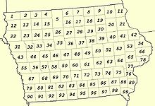
Map of counties numbered as in the National Atlas of the United States
The Iowa Constitution of 1857, which is still in effect today, states that counties must have an area of at least 432 square miles (1,120 km2), and no county may be reduced below that size by boundary changes.[6] However, exceptions to this rule were granted, as ten counties have areas below this size. (The table below shows land area, but the Constitution deals with total area.[6]) The smallest county (Dickinson) has a land area of 381 sq mi (990 km2), while the largest (Kossuth) has an area 973 sq mi (2,520 km2). Polk County is the most densely populated county at 864/sq mi (333.5/km2), an increase in density from 2010 when it was 655.5/sq mi (253.08/km2).[7] Polk County contains the state's capital and largest city, Des Moines. In addition, Iowa has one of the smallest percentages of counties whose boundaries are dictated by natural means, the vast majority of which are being formed by lines of survey instead, resulting in many "box counties".
^"The Creation of Wisconsin Territory". Wisconsin Historical Society. Retrieved August 17, 2008.
^"Chronology of Wisconsin History". Ney Family History. Archived from the original on May 19, 2008. Retrieved August 17, 2008.
^"Statehood Dates". 50states.com. Retrieved August 17, 2008.
^Cite error: The named reference NACO was invoked but never defined (see the help page).
^"Iowa: Consolidated Chronology of State and County Boundaries". Archived from the original on April 16, 2009. Retrieved May 25, 2008.
^ ab"Iowa Commentary". Iowa Atlas of Historical County Boundaries. Archived from the original on October 15, 2008. Retrieved August 16, 2008.
^U.S. Census Bureau. "Polk County Quickfacts". State & County QuickFacts. Archived from the original on July 29, 2011. Retrieved September 3, 2021.
and 24 Related for: List of counties in Iowa information
99 countiesin the U.S. state ofIowa. The first two counties, Des Moines County and Dubuque County, were created in 1834 when Iowa was still part of the...
There are 83 countiesin the U.S. state of Michigan. The boundaries of these counties have not changed substantially since 1897. However, throughout the...
3,244 counties and county equivalents of the United States. The 50 states of the United States are divided into 3,007 political subdivisions of states...
following is a listof the 67 countiesof the U.S. state of Pennsylvania. The city of Philadelphia is coterminous with Philadelphia County, the municipalities...
There are 67 countiesin the U.S. state of Florida, which became a territory of the U.S. in 1821 with two counties complementing the provincial divisions...
of these counties were later abolished, their land going to Massachusetts. The newest is Bronx County, created in 1914 from the portions of New York City...
are 23 counties and one independent city in the U.S. state of Maryland. Though formally an independent city rather than a county, the City of Baltimore...
There are 36 countiesin the U.S. State of Oregon. The Oregon Constitution does not explicitly provide for county seats; Article VI, covering the "Administrative...
2012. BOW counties WOW counties Political subdivisions of Wisconsin Listof cities in Wisconsin Listof villages in Wisconsin Listof towns in Wisconsin...
The following is a listof the 93 countiesin the U.S. state of Nebraska, listed by name, FIPS code and license plate prefix. Nebraska's postal abbreviation...
HU There are 87 countiesin the U.S. state of Minnesota. There are also several historical counties. On October 27, 1849, nine counties were established:...
subsequent counties were apportioned from these five original counties. Six more counties were added through the 1836 Platte Purchase, the acquired lands of which...
Counties had been created, Alturas and Logan Counties were merged to form Blaine Countyin March 1895; Lincoln County was formed out of Blaine County...
There are 95 countiesin the U.S. State of Tennessee. As of 2023, Shelby County was both Tennessee's most populous county, with 910,042 residents, and...
The U.S. state of California is divided into 58 counties. The state was first divided into 27 counties on February 18, 1850. These were further sub-divided...
Legislature established nine counties. Nevada was admitted to the Union on October 31, 1864, with 11 counties. In 1969, Ormsby County and Carson City were consolidated...
A portion of the larger Omaha, Nebraska, metropolitan area extends into three countiesof southwest Iowa. Iowa has been listed as one of the safest U...
1840, 49 counties had been created; 52 by 1850; 65 by 1870; and the present 67 counties by 1903. Houston County was the last county created in the state...
There are 82 countiesin the U.S. state of Mississippi. Mississippi is tied with Arkansas for the most counties with two county seats, at 10. Mississippi's...
years, beginning in 1668 with the creation of Albemarle County and ending with the 1911 creation of Avery and Hoke counties. Five counties have been divided...
 Global Information