 Global Information
Lewis and Clark National Forest information
| Lewis and Clark National Forest | |
|---|---|
 | |
 | |
| Location | Montana, U.S. |
| Nearest city | Great Falls, Montana |
| Coordinates | 47°11′N 111°27′W / 47.183°N 111.450°W |
| Area | 1,863,788 acres (7,542.48 km2)[1] |
| Established | February 22, 1897[2] |
| Governing body | U.S. Forest Service |
| Website | Lewis and Clark National Forest |
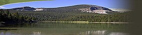
Lewis and Clark National Forest is located in west central Montana, United States. Spanning 2,912 square miles (7,500 km2), the forest is managed as two separate zones. The eastern sections, under the Jefferson Division, is a mixture of grass and shrublands dotted with "island" pockets of forested areas. Here, cattle leases to local ranchers as well as timber harvesting are the norm. The western Rocky Mountain Division, which straddles the Continental divide, is managed chiefly for environmental preservation, as much of the land has been designated as wilderness. Forest headquarters are located in Great Falls, Montana. Local ranger district offices have been established in Choteau, Harlowton, Neihart, Stanford, and White Sulphur Springs.[3]
The forest lands were defined and established by the federal government in 1897, following its Treaty of 1896 with the Blackfeet establishing their adjacent reservation. This forest is one of the oldest forest preserves in the U.S. The forest is named in honor of the members of the Lewis and Clark Expedition, which passed through the forest between 1804 and 1806 while exploring the Louisiana Purchase for President Thomas Jefferson.
Prior to that, the region was inhabited by various cultures of Native Americans for a period of at least 8,000–10,000 years. When the Lewis and Clark Expedition came to this area, different areas of the large forest territory were used by members of the Blackfeet, Sioux, Cheyenne, Flathead and Crow nations for hunting and as an area for their seasonal winter camps. The forests provided shelter from the winter.
- ^ "Land Areas of the National Forest System" (PDF). U.S. Forest Service. January 2012. Retrieved June 25, 2012.
- ^ "The National Forests of the United States" (PDF). Forest History Society. Retrieved June 25, 2017.
- ^ USFS Ranger Districts by State: Montana, US Forest Service