 Global Information
Lawriqucha River information
| Lawriqucha River | |
|---|---|
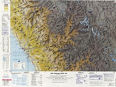 The headwaters of the Lawriqucha River may be seen in Sections 19 and 22 of this map. Map can be magnified. | |
| Etymology | Quechua |
| Location | |
| Country | Peru |
| Region | Huánuco |
| Physical characteristics | |
| Mouth | Marañón River |
Lawriqucha River (Huánuco Quechua lawri bluish,[1] Quechua qucha lake, lagoon,[2] "bluish lake", hispanicized spelling Lauricocha) is a river in the Huánuco Region in Peru. It belongs to the watershed of the Marañón River. The river is named after the lake Lawriqucha or Lauricocha.
The Lawriqucha River originates in a small glacial lake called Niñococha in the Raura mountain range at an elevation of 4,809 metres (15,778 ft).[3] In 1952 this lake was identified as the source of the Amazon River by an English explorer, Sebastian Snow. Several other sources of the Amazon have been proposed. From Niñococha the river flows north through the Raura mine to Lake Lauricocha.[4][5] Extensive mining began in the headwaters of the Lauricocha in 1927. The Raura mine is one of the highest in the world operating up to an elevation of 4,791 m (15,719 ft).[6] The extensive area of mining activity has polluted some of the area's lakes and interrupted the flow of the river. [7]
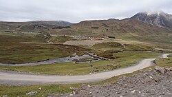
Near Lauricocha Lake is a stone bridge across the river dating back to the Inca Empire and still in use for horse and foot travel and the Lauricocha caves where archaeologists have found evidence of human habitation 10,000 years ago.[8][9] The river continues flowing north near the villages of Cauri (Kawri), Jesús and Jivia. Near the town of Rondos (Runtus) the Lawriqucha joins the Nupe River to form the Marañón. The elevation at the junction of the rivers is 3,316 metres (10,879 ft).[10]

The total length of the Lawriqucha River, in straight line distance from Niñococha Lake to its junction with the Nupe, is about 50 kilometres (31 mi).[11] A U.S intelligence agency map of the area calls the lower portion of the Lauricocha River the Quebrada Linda ("Beautiful Gorge").[12]
- ^ Diccionario Quechua - Español - Quechua, Academía Mayor de la Lengua Quechua, Gobierno Regional Cusco, Cusco 2005: Lawri - s. Hist. (etim. De un dialecto huanuqueño: azulado). Cementerio inkaico en la provincia de Chankay, Lima, Perú.
- ^ Teofilo Laime Ajacopa, Diccionario Bilingüe Iskay simipi yuyayk'ancha, La Paz, 2007 (Quechua-Spanish dictionary): qucha, qhucha, quchacha. - s. Laguna. Lago pequeño. qucha, qhucha. - s. Lago. Gran masa de agua en una depresión.
- ^ Google Earth Pro, coord: -10.456322, -76,756823
- ^ "Sebastian Snow," (7 May 2001) The Telegraph, [1], accessed 6 Oct 2018
- ^ Google Earth Pro, coord:-10.313315, -76.700480
- ^ Els, Eric (2015). "The world's 10 highest mines". Mining. Retrieved 22 April 2023.
- ^ Ricker, John (1974). "Cordillera Raura" (PDF). The American Alpine Journal. 19 (1). Retrieved 2016-05-27.
- ^ Enock, Reginald (1905), "The Ruins of 'Huanuco Viejo' or Old Huanuco, with Notes on an Expedition to the Upper Marañon," The Geographic Journal, Vol. 26, No. 2, page 162. Downloaded from JSTOR.
- ^ Fehren-Schmitz; L, Llamas, B.; Lindauer, S.; et al (2015), "A Re-Appraisal of Early Andean Human Remains from Lauricocha in Peru," PLOS ONE, Vol. 10, No. 6, page 2. DOI:10.1371
- ^ Google Earth Pro, coord:-9.988197, -76.683124
- ^ Google Earth Pro, coord: -9.988197, -76.683124 to coord: -10.456322, -76.756823
- ^ "Pativilca". Latin America Joint Operations Graphic. U.S. Department of Defense. Retrieved 20 April 2024.