This article is about the National Park in Sydney. For the suburban fungal site in Lane Cove to the south east, see Lane Cove Bushland Park.
Protected area in New South Wales, Australia
Lane Cove National Park New South Wales
IUCN category V (protected landscape/seascape)
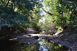
Upper Lane Cove River
Lane Cove National Park
Nearest town or city
Lane Cove
Established
1938 (1938)[1]
Area
6.7 km2 (2.6 sq mi)[1]
Managing authorities
NSW National Parks & Wildlife Service
Website
Lane Cove National Park
See also
Protected areas of New South Wales
The Lane Cove National Park is a protected national park that is located within metropolitan Sydney, in New South Wales, Australia. The 670-hectare (1,700-acre) national park is situated about 10 kilometres (6.2 mi) north-west of the Sydney central business district and features various vegetation types, such as, wet and dry sclerophyll forest, heathland, mangroves and tidal flats. The park consists of land near the banks of the Lane Cove River, which flows generally south-east into Sydney Harbour. It also extends to the outskirts of Pennant Hills and Wahroonga at its northern boundaries.
^ abLane Cove National Park: Plan of Management(PDF) (PDF). Government of New South Wales. August 2016. ISBN 978-0-7310-7658-1. Retrieved 26 October 2016. {{cite book}}: |work= ignored (help)
and 21 Related for: Lane Cove National Park information
the local government area of the LaneCove Council. LaneCove West and LaneCove North are separate suburbs. LaneCove occupies a peninsula on the northern...
LaneCove Bushland Park is located in suburban LaneCove, 5 kilometres from the centre of Sydney, Australia. It is regarded as one of the more interesting...
within the LaneCoveNationalPark, an area of 598 hectares (1,480 acres), formerly a State Recreation Area. The lower reaches of the LaneCove River, downstream...
LaneCove Council is a local government area located on the Lower North Shore of Sydney, New South Wales, Australia. The administrative seat of Lane Cove...
LaneCove North is a suburb on the Lower North Shore of Sydney, in the state of New South Wales, Australia. LaneCove North is located 11 kilometres north-west...
LaneCove West is a suburb on the Lower North Shore of Sydney, in the state of New South Wales, Australia. LaneCove West is located 9 kilometres north-west...
Turramurra is a leafy suburb, surrounded by the upper section of the LaneCoveNationalPark. There are many walking trails, including the Great North Walk...
Highway with LaneCoveNationalPark in South Turramurra. It is owned and maintained by Ku-ring-gai Council. There are two Rofe Parks: Rofe Park Hornsby Heights...
LaneCove River Tourist Park is a caravan park and campground in the Australian state of New South Wales located in the suburb of Macquarie Park within...
"What's flowering in the park - Commelina cyanea". Friends of LaneCoveNationalPark website. Friends of LaneCoveNationalPark. Retrieved 16 April 2011...
the current premises weren't occupied until 1968, it adjoins the LaneCoveNationalPark. The school has links with nearby Macquarie University and the...
Comenarra Park on the Comenarra Parkway has cricket and a soccer field. It also has bushwalking tracks leading into the LaneCoveNationalPark. Scouting...
Lagoon Healesville Sanctuary, Victoria, Australia Audley, Sydney LaneCoveNationalPark "Varanus varius". IUCN Red List of Threatened Species. 2018. e...
the six lane, 33 metre pool with an eight lane, 25 metre pool. In February 2015, local residents and community action group Save Petersham Park organised...
flowers. Eastern water dragon (Intellagama lesueurii lesueurii) at LaneCoveNationalPark Australian water dragon, Brisbane Intellagama lesueurii lesueurii...
constituent part of the A3 route. LaneCove Road commences at the De Burghs Bridge, crossing the LaneCove River at Macquarie Park and connecting with Ryde Road...
Chatswood to North Ryde as part of the A38. The main entrance to LaneCoveNationalPark is located adjacent to the western end of Fullers Bridge. Completed...
 Global Information