Lake Vilacota[1][2] (possibly from Aymara wila red / blood, quta lake,[3] "red lake") is a lake in the region of Tacna, in Peru. More precisely, it belongs to Tarata Province, Susapaya District, along the border with the Santa Rosa District of El Collao Province in the neighboring region of Puno.[2] It has a surface elevation of 4,390 metres (14,403 ft) above sea level[4] and a catchment area of 1,440 square kilometres (556 sq mi).[5]
Yucamane volcano lies west of the lake.[1] To the east of Lake Vilacota there is a smaller lake named Ancocota[1] (possibly Aymara for "white lake");[citation needed] both lakes being connected by a short river.[1] Moreover, both lakes are the headwaters of Mauri River.[4]
LakeVilacota (possibly from Aymara wila red / blood, quta lake, "red lake") is a lake in the region of Tacna, in Peru. More precisely, it belongs to Tarata...
Huichicocha Vilacota Huiñaymarca Yanawayin Yanaqucha Lakes portal List of lakes List of lakes by area List of lakes by depth List of lakes by volume Instituto...
Province, Susapaya District. Chillihua lies southwest of the lakesVilacota and Lake Neque ("mud lake"). escale.minedu.gob.pe - UGEL map of the Tarata Province...
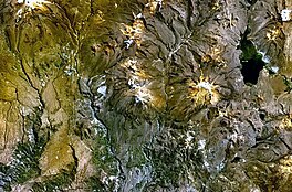
(the first snow-covered peak north of it above the river valley) and LakeVilacota (on the right) as seen from above (NASA Landsat7 image) Highest point...
70°12′20″W / 14.07778°S 70.20556°W / -14.07778; -70.20556 between the lakes Vilacota in the northwest and Pampacocha and Ajojajota in the southeast. escale...
Tacna Region, Candarave Province, Candarave District of Peru, west of lakeVilacota. The town of Candarave lies 7 kilometres (4.3 mi)-11 kilometres (6.8 mi)...
Climate data for LakeVilacota, Susapaya, elevation 4,390 m (14,400 ft), (1991–2020) Month Jan Feb Mar Apr May Jun Jul Aug Sep Oct Nov Dec Year Mean daily...
Wilaquta (Aymara for "red lake", other spellings Huila Kkota, Huilacota, Vila Ccota, Vila Cota, Velacota, Vilaccota, Vilacota, Vilajota, Vilakkota, Vilakota...
a /q/, an instance of allophonic variation. For instance, Quechua qucha 'lake' sounds to Spanish speakers like cocha, as in the sample Huiracocha below...
(14,829 ft) Vilacota, 5,179 metres (16,991 ft) Huejo, 4,900 metres (16,076 ft) Yanauma, 5,009 metres (16,434 ft) Yana Urqu The largest lake in the range...
metres (19,000 ft) there was perpetual snow. The volcano is part of the Vilacota Maure Regional Conservation Area [es]. The oldest volcanic rocks of Tutupaca...
 Global Information