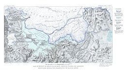
Lake Great Falls was a prehistoric proglacial lake which existed in what is now central Montana in the United States between 15,000 BCE and 11,000 BCE.[3][4][5] Centered on the modern city of Great Falls, Montana, Glacial Lake Great Falls extended as far north as Cut Bank, Montana, and as far south as Holter Lake.[6] At present-day Great Falls, the Glacial Lake Great Falls reached a depth of 600 feet (183 metres).[7]
Approximately 1.5 million years ago, the Missouri River, the Yellowstone River and Musselshell River all flowed northward into a terminal lake.[8][9] During the last glacial period, the Laurentide and Cordilleran ice sheets pushed these lakes and rivers southward.[3][8] Between 15,000 BCE and 11,000 BCE, the Laurentide Ice Sheet blocked the Missouri River and created Glacial Lake Great Falls.[3][4][5]
About 13,000 BCE, as the glacier retreated, Glacial Lake Great Falls emptied catastrophically in a glacial lake outburst flood.[5] The meltwater poured through the Highwood Mountains and eroded the hundred mile-long, 500-foot-deep (150 m) Shonkin Sag—one of the most famous prehistoric meltwater channels in the world.[10]
Map of Montana showing glacial lakes.
^dewiki
^Physiography and Glacial Geology of Eastern Montana and Adjacent Areas; William C. Alden; United States Government Printing Office: Washington, D.C.; 1932
^ abcMontagne J.L. "Quaternary System, Wisconsin Glaciation." Geologic Atlas of the Rocky Mountain Region. Denver: Rocky Mountain Association of Geologists, 1972.
^ abHill, Christopher L. and Valppu, Seppo H. "Geomorphic Relationships and Paleoenvironmental Context of Glaciers, Fluvial Deposits, and Glacial Lake Great Falls, Montana." Current Research in the Pleistocene. 14 (1997); Hill, Christopher L. "Pleistocene Lakes Along the Southwest Margin of the Laurentide Ice Sheet." Current Research in the Pleistocene. 17 (2000); Hill, Christopher L. and Feathers, James K. "Glacial Lake Great Falls and the Late-Wisconsin-Episode Laurentide Ice Margin." Current Research in the Pleistocene. 19 (2002); Reynolds, Mitchell W. and Brandt, Theodore R. Geologic Map of the Canyon Ferry Dam 30' x 60' Quadrangle, West-Central Montana: U.S. Geological Survey Scientific Investigations Map 2860, scale 1:100,000. Scientific Investigations Map 2860. Washington, D.C.: U.S. Geologic Survey, 2005.
^ abcFeathers, James K. and Hill, Christopher L. "Luminescence Dating of Glacial Lake Great Falls, Montana, U.S.A." Archived 2014-11-29 at the Wayback Machine XVI International Quaternary Association Congress. Stratigraphy and Geochronology Session. International Quaternary Association, Reno, 2003.
^Kidston, Martin J. "Prehistoric Find." Helena Independent Record. June 20, 2004.
^Alt, David and Hyndman, Donald W. Roadside Geology of Montana. Missoula, Mont.: Mountain Press Publishing, 1986. ISBN 0-87842-202-1; Stickney, Michael C. "Quaternary Geology and Faulting in the Helena Valley." In 1987 Guidebook for the Helena Area, West-Central Montana: Guidebook for the 12th Annual Field Conference. Richard B. Berg and Ray H. Breuninger, eds. Montana Bureau of Mines and Geology Special Publication 95. Helena, Mont.: Montana Bureau of Mines and Geology, 1987.
^ abClawson, Roger and Shandera, Katherine A. Billings: The City and the People. Helena, Mont.: Farcountry Press, 1998. ISBN 1-56037-037-8
^McRae, W.C. and Jewell, Judy. Moon Montana. 7th ed. Cambridge, Massachusetts: PublicAffairs, 2009. ISBN 1-59880-014-0
^Axline, Jon and Bradshaw, Glenda Clay. Montana's Historical Highway Markers. Rev. ed. Helena, Mont.: Montana Historical Society, 2008. ISBN 0-9759196-4-4; Bowman, Isaiah. "Forest Physiography: Physiography of the United States and Principles of Soils in Relation to Forestry." American Environmental Studies. Reprint ed. Charles Gregg, ed. New York: Arno Press, 1970. ISBN 0-405-02659-5
LakeGreatFalls was a prehistoric proglacial lake which existed in what is now central Montana in the United States between 15,000 BCE and 11,000 BCE...
The GreatLakes (French: Grands Lacs), also called the GreatLakes of North America, are a series of large interconnected freshwater lakes in the east-central...
GreatLakes Waterway (GLW) is a system of natural channels and artificial locks and canals which enable navigation between the North American Great Lakes...
the newly formed GreatLakes carved a path over and through the Niagara Escarpment en route to the Atlantic Ocean. Horseshoe Falls is about 57 m (187 ft)...
Great East Lake is the largest of the Salmon Falls headwater lakes. Great East Lake supports abundant wildlife, and 21 fish species including lake trout...
The GreatLakes region of Northern America is a binational Canadian–American region centered around the GreatLakes that includes the U.S. states of Illinois...
GreatFalls International Airport (IATA: GTF, ICAO: KGTF, FAA LID: GTF) is a public/military airport in city limits three miles southwest of central Great...
River) Niagara Falls, New York (Niagara River) Niagara Falls, Ontario (Niagara River) Grosse Ile, Michigan (Detroit River) List of ports on the GreatLakes...
Lake Erie (/ˈɪəri/ EER-ee; French: Lac Érié) is the fourth-largest lake by surface area of the five GreatLakes in North America and the eleventh-largest...
Blewett FallsLake (sometimes incorrectly spelled as Blewitt FallsLake) is a reservoir located in Anson and Richmond counties in the U.S. state of North...
GreatFalls Park is a small National Park Service (NPS) site in Virginia, United States. Situated on 800 acres (3.2 km2) along the banks of the Potomac...
Great Central Lake is a lake on Vancouver Island, British Columbia, Canada. It is located north of Sproat Lake and to the northwest of the city of Port...
Great Bear Lake (Slave: Sahtú; French: Grand lac de l'Ours) is a lake in the boreal forest of Canada. It is the largest lake entirely in Canada (Lake...
and dump significant falls of rain or snow. Fueled by the warm lake water, these powerful storms may remain over the GreatLakes for days. November gales...
central North America, it is the northernmost and westernmost of the GreatLakes of North America, straddling the Canada–United States border with the...
formed by the Missouri River and glacial meltwater pouring from Glacial LakeGreatFalls. It is one of the most famous prehistoric meltwater channels in the...
cataclysmic outburst flooding of Lake Bonneville during the Pleistocene ice age about 14,000 years ago, Shoshone Falls marks the historical upper limit...
Niagara Falls, which marks roughly the western terminus of the former lake bed. The remains of the previous falls, which rivaled Niagara Falls in grandeur...
Lake Ontario is one of the five GreatLakes of North America. It is bounded on the north, west, and southwest by the Canadian province of Ontario, and...
FallsLake State Recreation Area is a North Carolina state park in Durham and Wake counties, North Carolina in the United States. Near Wake Forest, North...
 Global Information