Dagenais River, Duparquet River, La Reine River, La Sarre River, Low Bush River
Primary outflows
Abitibi River
Basin countries
Canada
Surface area
931 km2 (359 sq mi)
Average depth
3.5 m (11 ft)
Max. depth
15.0 m (49.2 ft)
Surface elevation
265 m (869 ft)
Islands
over 900
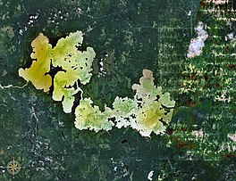
Lake Abitibi (French: Lac Abitibi, Ojibwe: Aabitibiiwi-zaaga’igan) is a shallow lake in northeastern Ontario and western Quebec, Canada. The lake, which lies within the vast Clay Belt, is separated in two distinct portions by a short narrows, making it actually two lakes. Its total area is 931 square kilometres (359 sq mi), and net area 903 square kilometres (349 sq mi).[1] The lake is shallow and studded with islands. Its shores and vicinity are covered with small timber.
Its outlet is the Abitibi River, a tributary of the Moose River, which empties into James Bay. The lake takes its name from the river. "Abitibi" comes from the Algonquin words abitah, meaning middle and nipi meaning water,[2] possibly a reference to its geographic location between the Harricana (from the Algonquin word Nanikana, meaning "the main way")[3] to the east and the Kapuskasing–Mattagami river system to the west.
Water levels on the lake are influenced by the Twin Falls Dam on the Abitibi River.
Portions of Lake Abitibi's southern shores and a section of the Abitibi River are part of the Abitibi-de-Troyes Provincial Park. The islands in Ontario's portion of the lake are protected in the Lake Abitibi Islands Provincial Park. The entire McDougall Point Peninsula, that separates the lake in two, is part of the 6,036 hectares (14,920 acres) Mcdougal Point Peninsula Conservation Reserve.[4]
Pointe Abitibi at the mouth of the Duparquet River is a National Historic Site of Canada.[5] This 272 hectares (670 acres) site, known as Apitipik National Historic Site of Canada, was a summer gathering place for the Abitibiwinnik until 1956 and the location of several trading posts between 1686 and 1922.[6]
^Atlas of Canada Archived 2007-04-10 at the Wayback Machine
^Hoiberg, Dale H., ed. (2010). "Abitibi River". Encyclopædia Britannica. Vol. I: A-ak Bayes (15th ed.). Chicago, IL: Encyclopædia Britannica Inc. pp. 33. ISBN 978-1-59339-837-8.
^Environnement Québec, North Harricana River Aquatic Reserve|http://www.mddep.gouv.qc.ca/biodiversite/aquatique/harricana-nord/note-en.pdf Archived 2011-06-16 at the Wayback Machine Online version
^"Crown Land Use Policy Atlas Policy Report C1714: Mcdougal Point Peninsula Conservation Reserve". www.gisapplication.lrc.gov.on.ca. Ministry of Natural Resources. 31 January 2006. Archived from the original on 21 September 2021. Retrieved 21 September 2021.
^"Pointe Abitibi". Geographical Names Data Base. Natural Resources Canada.
^"Apitipik National Historic Site of Canada". www.pc.gc.ca. Parks Canada. Archived from the original on 22 September 2021. Retrieved 21 September 2021.
LakeAbitibi (French: Lac Abitibi, Ojibwe: Aabitibiiwi-zaaga’igan) is a shallow lake in northeastern Ontario and western Quebec, Canada. The lake, which...
The Abitibi River is a river in northeastern Ontario, Canada, which flows northwest from LakeAbitibi to join the Moose River which empties into James...
town centre lies 11 km east of Hwy 11 on the banks of the Abitibi River, west of LakeAbitibi. Timmins, one of the largest cities in northern Ontario,...
population was 121. The first recorded reference to the native people about LakeAbitibi was in The Jesuit Relations in 1640. They were a nomadic group of hunter-gatherers...
Noyon Island Bishops Point Island Long Point Island Islands of the Great Lakes Ontario Geographic Names Board (6 April 2010). "Race Island" (PDF). Ontario...
This is a partial list of lakes of Canada. Canada has an extremely large number of lakes, with the number of lakes larger than three square kilometres...
Lake Nipigon, then runs as far south as the 48th parallel before veering north again to cross the western border of Quebec just south of LakeAbitibi...
forest management in the Northern Clay Section: a literature review. LakeAbitibi Model Forest Technical Report No.1. 75 p. link: "Archived copy" (PDF)...
(RCM), in the administrative region of Abitibi-Témiscamingue, in the province of Quebec, in Canada. Barry Lake is the head of the Saint-Cyr River South...
Bay Company established Abitibi House on LakeAbitibi, to the north. In 1886, Alexander H. Telfer led a survey trip up Lake Timiskaming and gave a report...
Holden LakeLake Huron Horseshoe Lake multiple lakes Inn Lake Indian Lake Innis Lake Irwin Lake Ivanhoe Lake Jack Lake Jeff LakeLake Joseph Jules Lake Jumping...
the Abitibi-Ouest Regional County Municipality. It is located at the intersection of Routes 111 and 393, on the La Sarre River, a tributary of Lake Abitibi...
Municipality (RCM), in the administrative region of Abitibi-Témiscamingue, in Quebec, Canada. Lake Maricourt is located entirely in the township of Maricourt...
Great Clay Belt to the north running eastward from Kapuskasing, past LakeAbitibi and on to Amos, and the V-shaped Lesser Clay Belt to its south, running...
Municipality (RCM), in the administrative region of Abitibi-Témiscamingue, in the province of Quebec, in Canada. Lake Faillon is crossed to the Southwest by the...
(RCM), in the administrative region of Abitibi-Témiscamingue, in the province of Quebec, in Canada. Canusio Lake is located in the township of Noiseux...
(RCM), in the administrative region of Abitibi-Témiscamingue, in the province of Quebec, in Canada. Mesplet Lake is located in the township of Mesplet...
Parent Lake is an enlargement of the Bell River, flowing north-west into the Matagami Lake. It is located in a swampy area of Abitibi Regional County Municipality...
(RCM), in the administrative region of Abitibi-Témiscamingue, in the province of Quebec, in Canada. Girouard Lake is located entirely in the township of...
(RCM), in the administrative region of Abitibi-Témiscamingue, in the province of Quebec, in Canada. Cherrier Lake is located in the township of Mesplet...
See also References Lake 3.1416 LakeAbitibi in Ontario and Quebec Lake Albanel Allioux Lake Archange Lake (Mékinac) Lake Arpin Lake Aylmer Baskatong Reservoir...
Vallée-de-l'Or Regional County Municipality (RCM), in the administrative region of Abitibi-Témiscamingue, in the province of Quebec, in Canada. Forestry is the main...
 Global Information