 Global Information
Lake Abaya information
| Lake Abaya | |
|---|---|
 | |
 Lake Abaya | |
 | |
| Coordinates | 6°26′N 37°53′E / 6.433°N 37.883°E |
| Primary inflows | Bilate River Gidabo River Gelana River |
| Basin countries | Ethiopia |
| Max. length | 60 km (37 mi) |
| Max. width | 20 km (12 mi) |
| Surface area | 1,162 km2 (449 sq mi) |
| Average depth | 7.1 m (23 ft) |
| Max. depth | 13.1 m (43 ft) |
| Water volume | 8.2 km3 (2.0 cu mi) |
| Surface elevation | 1,175 m (3,855 ft) |
| Settlements | Arba Minch |
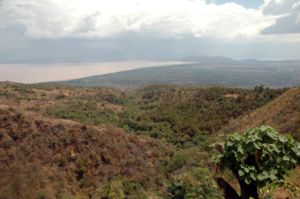
Lake Abaya (Amharic: አባያ ሐይቅ) is a lake in the Southern Nations, Nationalities, and Peoples' Region of Ethiopia. It is located in the Main Ethiopian Rift, east of the Guge Mountains.
The town of Arba Minch lies on its southwestern shore, and the southern shores are part of the Nechisar National Park. Just to the south is Lake Chamo. Savanna, known for its wildlife and birdlife, surrounds the lake, which is also fished by local people. According to the Ethiopian Department of Fisheries and Aquaculture, 412 tonnes of fish are landed each year, which the department estimates is 69% of its sustainable amount.[1]
Lake Abaya is 60 kilometers long and 20 wide,[2] with a surface area of 1162 square kilometers.[3] There are a number of islands in this lake, the largest being Aruro;[4] others include Gidicho, Welege, Galmaka, and Alkali. The lake is red due to a high load of suspended sediments.[5]
The lake is fed by three medium-sized rivers. First there is the Bilate which rises on the southern slopes of Mount Gurage, then runs mostly southward to drain into Lake Abaya at its northern shore. Second, there is the Gidabo, which rises on the western slopes of the Bale Mountains, then also runs mostly southwards to drain into Lake Abaya at its northeastern tip after having passed the Gidabo flood plains. A third river is the Gelana, which rises at the western escarpment of the Rift Valley northwest of Bule Hora Town. Tributary streams also rise on the eastern and northern slopes of the Amaro Mountains. The Gelana then flows northwards through the Gelana Graben in the middle between both mountain ranges before it enters the Bore swamps and finally drains on the eastern side into the lake.
The only outflow of the lake is through the lower reaches of Kulfo River directly below an alluvial fan at an elevation of 1,190 m (at 6°00′39″N 37°35′07″E / 6.0109°N 37.5854°E). The riverbed acts as an spillway in the case of high lake levels and discharges the excess water into Lake Chamo. Usually, the lake level oscillates somewhat, in 2017 it was at 1,175 m, 15 m below the overflow level.[6] In the last 50 years, the lake level oscillated only ±1.5 m around a mean value which is well below the overflow level.[7] Consequently, the maximum depth of the lake changes only slightly from year to year, in the year 2002 the lake had a maximum depth of 13.1 meters.[3]
In 1896 Lake Abaya was renamed "Lake Margherita" after the Queen Margherita of Savoy, wife of King Humbert I of Italy by the Italian explorer Vittorio Bottego who first explored the region. The name "Lake Margherita" (Lago Margherita) is still used in Italy.[8]
- ^ "Information on Fisheries Management in the Federal Democratic Republic of Ethiopia" Archived 2008-02-28 at the Wayback Machine (report dated January, 2003)
- ^ Statistical Abstract of Ethiopia for 1967/68
- ^ a b Baxter, R. M. Lake Morphology and Chemistry. in Taylor, W.D. and Tudorancea, C., eds. Ethiopian Rift Valley Lakes. Leiden: Backhuys Publishers, 2002.
- ^ "Local History in Ethiopia" Archived 2007-09-27 at the Wayback Machine The Nordic Africa Institute website (accessed 5 November 2007)
- ^ A. T. Grove; F. A. Street; A. S. Goudie, 1975: "Former Lake Levels and Climatic Change in the Rift Valley of Southern Ethiopia," Geographical Journal 141, 177-194
- ^ Google Earth
- ^ Ababu Teklemariam, Bernd Wenclawia (2004). "Water Quality monitoring within the Abaya-Chamo Drainage Basin" (PDF). Archived from the original (PDF) on 2018-02-07. Retrieved 2018-02-06.
- ^ Mack Smith, Denis. Mussolini’s Roman Empire. New York: Viking, 1976.