Kutch district, officially spelled Kachchh, is a district of Gujarat state in western India, with its headquarters (capital) at Bhuj. Covering an area of 45,674 km2,[1] it is the largest district of India. The area of Kutch is larger than the entire area of other Indian states like Haryana (44,212 km2) and Kerala (38,863 km2).[2] The population of Kutch is about 2,092,371.[3] It has 10 talukas, 939 villages and 6 municipalities.[3] The Kutch district is home to the Kutchi people who speak the Kutchi language.
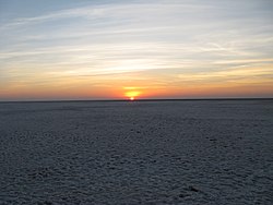
Kutch literally means something which intermittently becomes wet and dry; a large part of this district is known as Rann of Kutch which is shallow wetland which submerges in water during the rainy season and becomes dry during other seasons. The same word is also used in Sanskrit origin for a tortoise. The Rann is known for its marshy salt flats which become snow white after the shallow water dries up each season before the monsoon rains.
The district is also known for ecologically important Banni grasslands with their seasonal marshy wetlands which form the outer belt of the Rann of Kutch.
Kutch is surrounded by the Gulf of Kutch and the Arabian Sea to the south and west, while the northern and eastern parts are surrounded by the Great and Little Rann (seasonal wetlands) of Kutch. It is also next to the border with Pakistan, a neighbouring country of India. When there were not many dams built on its rivers, the Rann of Kutch remained wetlands for a large part of the year. Even today, the region remains wet for a significant part of year. The district had a population of 2,092,371 as of 2011 census, of which 30% were urban.[4] Motor vehicles registered in Kutch district have a registration number starting with GJ-12. The district is well connected by road, rail and air. There are four airports in the district: Naliya, Anjar, Mundra, and Bhuj. Bhuj and Anjar are well connected with Mumbai airport. Being a border district, Kutch has both an army and an air force base.
^"Kutch" (PDF). Vibrantgujarat.com. Archived from the original (PDF) on 21 October 2012. Retrieved 17 November 2012.
^Sen, Kavita (January 2001). "Economic consequences of the Gujarat earthquake". Academia. Retrieved 21 May 2021.
^ ab"About Kutch | About Us | Collectorate - District Kutch". Archived from the original on 27 June 2018. Retrieved 8 February 2016.
^"Census GIS India". Censusindiamaps.net. Archived from the original on 11 January 2010. Retrieved 17 November 2012.
Kutchdistrict, officially spelled Kachchh, is a district of Gujarat state in western India, with its headquarters (capital) at Bhuj. Covering an area...
The Rann of Kutch is a large area of salt marshes that span the border between India and Pakistan. It is located mostly in the Kutchdistrict of the Indian...
The Great Rann of Kutch (or Rann of Kutch seasonal salt marsh) is a salt marsh in the Thar Desert in the KutchDistrict of Gujarat, India. It is about...
The Little Rann of Kutch is a salt marsh which is part of the Rann of Kutch in Kutchdistrict, Gujarat, India. The Little Rann of Kutch is home to the Indian...
Kutch State was a state within India from 1947 to 1956. Its capital was Bhuj. The state's territory now forms a Kachchh district within the Indian state...
Kachchh Lok Sabha constituency (formerly Kutch Lok Sabha constituency) is one of the 26 Lok Sabha (parliamentary) constituencies in Gujarat state in western...
The Kutch Desert Wildlife Sanctuary is situated in the Great Rann of Kutch, Kutchdistrict, Gujarat, India. It was declared a sanctuary in February 1986...
The Kutch Embroidery is a handicraft and textile signature art tradition of the tribal community of KutchDistrict in Gujarat, India. This embroidery with...
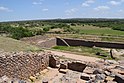
The history of Kutch, (kachchh) a region in the extreme west of the western Indian state of Gujarat, can be traced back to prehistorical times. There...
southern edge of the desert of the marshy salt flats of Rann of Kutch in KutchDistrict, Gujarat State, India. They are known for rich wildlife and biodiversity...
Luna crater is an impact crater at Luna village in Bhuj taluka of Kutchdistrict of Gujarat, India. The crater is located in a low-lying, soft, flat area...
"Explorations, and excavations: Gujarat: 19. Excavation at Desalpur (Gunthli), DistrictKutch" (PDF). Indian Archaeology 1963-64, A Review. Indian Archaeology (1963–64):...
layers of the Naredi Formation in the Panadhro Lignite Mine in the Kutchdistrict of Gujarat State, western India. The specimen consists of 27 pre-cloacal...
district in the north and northeast, Mehsana district in the east and southeast, Surendranagar district in the south and KutchDistrict and the Kutch...
river. This natural dam was known as the Allah Bund ("Dam of God"). The KutchDistrict of modern-day Gujarat lies 300–400 km (190–250 mi) from the plate boundary...
seaport in Kutchdistrict of Gujarat state in western India. The Port is situated in the Kandla Creek and is 90 km from the mouth of Gulf of Kutch, it is...
Hajipir is located in Kutchdistrict, Gujarat, India. The Dargah located there is dedicated to a Muslim saint Hajipir. It is believed that he came to the...
commercial port, located on the northern shores of the Gulf of Kutch near Mundra, Kutchdistrict, Gujarat. Formerly operated by Mundra Port and Special Economic...
Barmer district. After travelling a length of almost 500 km, it passes through Jalore and merges in the marshy land of Runn of Kutch. District headquarters...
Mata no Madh is a village in Lakhpat Taluka of Kutchdistrict, Gujarat, India. The village lies surrounded by hills on both banks of a small stream and...
and a municipality in Kutchdistrict (kachchh) in the state of Gujarat, India. Bhachau was one of many devastated towns in the Kutch region of the Indian...
construction renewable energy park located near Vighakot village in Kutchdistrict of Gujarat, India. It is located very close to the international border...
Gujarat has 252 talukas(tehsils,sub-districts). The urban status is listed for the headquarters town of the taluka, rural talukas are much larger. Urban...
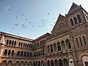
(pronunciation) is a city and the headquarters of Kutchdistrict in the Indian state of Gujarat. According to legend, Kutch (Kachchh) was ruled by the Nāga chieftains...
ڪڇي (Perso-Arabic); कच्छी (Devanagari)) traditionally hail from the Kutchdistrict of the western Indian state of Gujarat and the Sindh region of Pakistan...
Allahyar District, Northwest by Hyderabad District, on the east by Mirpur Khas and Tharparkar districts, on the south by the Kutchdistrict of India,...
the eastern part of Kutchdistrict in the state of Gujarat and it is the largest and most populous city in (Kachchh) KutchDistrict, Gujarat, India. It...
 Global Information