 Global Information
Kulbatpur information
Kulbatpur | |
|---|---|
Village | |
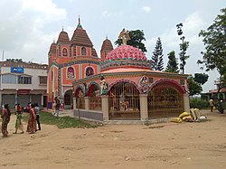 Kulbatpur Kali Temple | |
 MAP OF KULBATPUR | |
 Kulbatpur Location in West Bengal, India  Kulbatpur Kulbatpur (India) | |
| Coordinates: 22°53′28″N 87°56′03″E / 22.8911449°N 87.93428°E | |
| Country | |
| State | West Bengal |
| District | Hooghly |
| Nearest City | Tarakeswar |
| Area | |
| • Total | 2 km2 (0.8 sq mi) |
| Population (2011) | |
| • Total | 4,038 |
| • Density | 2,000/km2 (5,200/sq mi) |
| Languages | |
| • Official | Bengali, |
| Time zone | UTC+5:30 (IST) |
| Telephone code | 712414 |
| ISO 3166 code | IN-WB |
| Lok Sabha constituency | Arambagh |
| Vidhan Sabha constituency | Pursurah |
Kulbatpur is a village in Pursurah community development block of Arambagh subdivision in Hooghly District in the Indian state of West Bengal. It is 7 km from Tarakeswar .[1]
- ^ "Mouza Information". Land & Land Reforms Department, Government of West Bengal.