 Global Information
Kukusunda information
| Kukusunda Кукусунда / Кукуһунда | |
|---|---|
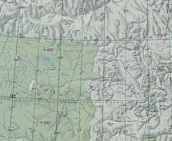 Arga-Sala basin ONC map section with the Kukusunda in the lower part | |
 Mouth location in Yakutia, Russia  Kukusunda (Russia) | |
| Location | |
| Country | Russia |
| Physical characteristics | |
| Source | |
| • location | Anabar Plateau Central Siberian Plateau |
| Mouth | Arga-Sala |
• coordinates | 68°18′32″N 109°51′51″E / 68.30889°N 109.86417°E |
• elevation | 108 m (354 ft) |
| Length | 270 km (170 mi) |
| Basin size | 14,200 km2 (5,500 sq mi) |
| Discharge | |
| • average | 99 m3/s (3,500 cu ft/s) |
| Basin features | |
| Progression | Arga-Sala→Olenyok→Laptev Sea |
The Kukusunda (Russian: Кукусунда; Yakut: Кукуһунда, Kukuhunda) is a river in Yakutia (Sakha Republic) and Krasnoyarsk Krai, Russia. It is the longest tributary of the Arga-Sala, of the Olenyok basin, and has a length of 270 kilometres (170 mi) and a drainage basin area of 14,200 square kilometres (5,500 sq mi).[1]
The river flows across an uninhabited area of Olenyoksky District marked by permafrost. A small stretch of its source area falls within the Evenkiysky District of Krasnoyarsk Krai. The nearest settlement is Olenyok village, located about 200 km (120 mi) to the east of its mouth.[2]
- ^ "Река Кукусунда in the State Water Register of Russia". textual.ru (in Russian).
- ^ Cite error: The named reference
STMwas invoked but never defined (see the help page).