c. 20 million cubic metres per annum (710×10^6 cu ft/a)
Basin features
Tributaries
• left
Gomab River, Ojab River, Chausib River, Gaub River
• right
Koam River, Nausgomab River, Goagos River
Waterbodies
Friedenau Dam
The Kuiseb River is an ephemeral river in western-central Namibia. Its source is in the Khomas Highland west of Windhoek. From there it flows westwards through the Namib-Naukluft National Park and the Namib desert to Walvis Bay. Several settlements of the Topnaar people are on the banks of the lower Kuiseb, for instance Homeb, Sandfontein, Rooibank, and Utuseb.[1][2] Inflows of the Kuiseb are Gomab, Ojab, Chausib, Gaub, Koam, Nausgomab and Goagos.[3]
The Kuiseb's catchment area (including its tributaries) is estimated to be between 15,500[3] and 16,692 km2 (6,445 sq mi).[4] It has a mean run-off of roughly 20 million cubic metres per annum (710×10^6 cu ft/a).[5] Friedenau Dam, built in 1972, is on the river.[6] In January 2005, for the first time in years, the Kuiseb flowed to the ocean.
Between Naukluft and Namib the Kuiseb carved out a canyon in a barren and inaccessible area. During World War II the area around the Kuiseb Canyon served as a shelter for Henno Martin and Hermann Korn who moved there to wait the war out.[7] Two books and a film were subsequently published about this 2-year stay; the ruins of their shelter can be visited. On its course through the Namib the Kuiseb is bordered on one side by some of the tallest sand dunes in the world, and on the other by barren rock.[3] The red sand dunes south of the river reach heights over 150 meters. The prevailing winds blow the dunes northward, but their movement is blocked by the river. In the process, so much sand and silt is deposited in the Kuiseb that it only reaches the sea while it is in flood.[8]
In 1907, the area between the Swakop River and the Kuiseb was designated by the German colonial administration as a game reserve. The area is currently part of the Namib-Naukluft National Park. The Desert Research Foundation of Namibia (DRFN) is located at Gobabeb on the banks of the river.[9]
Natural-colour satellite image of the Kuiseb River.
Aerial view of Kuiseb River (2017)
Kuiseb River (2018)
Aerial view of the Gobabeb Training and Research Centre
Ruins of the Shelter of Korn and Martin
C14 bridge over the Kuiseb Canyon
^Malan 1998, p. 120–125.
^Moritz 1997, pp. 4–5.
^ abcJacobson, Peter J.; Jacobson, Kathryn M.; Seely, Mary K. (1995). Ephemeral rivers and their catchments: Sustaining people and development in western Namibia(PDF 8.7MB). Windhoek: Desert Research Foundation of Namibia. pp. 140–141. ISBN 9991670947.
^Strohbach, B.J. (2008). "Mapping the Major Catchments of Namibia" (PDF 1.0MB). Agricola. 2008: 63–73. ISBN 9780353358164. ISSN 1015-2334. OCLC 940637734.
^"ELECTIONS 2010: Erongo regional profile". New Era. 16 November 2010. Archived from the original on 6 September 2012.
^Friedenau Archived 2008-11-21 at the Wayback Machine at NamWater
^Martin, Henno (2006). The Sheltering Desert. Hamburg: Two Books. ISBN 9783935453035.
^Morin, Efrat; Grodek, Tamir; Dahan, Ofer; Benito, Gerardo; Kulls, Christoph; Jacoby, Yael; Langenhove, Guido Van; Seely, Mary; Enzel, Yehouda (April 2009). "Flood routing and alluvial aquifer recharge along the ephemeral arid Kuiseb River, Namibia". Journal of Hydrology. 368 (1–4): 262–275. doi:10.1016/j.jhydrol.2009.02.015. ISSN 0022-1694.
^"Desert Research Foundation of Namibia". namibweb.com. Retrieved 3 October 2019.
The KuisebRiver is an ephemeral river in western-central Namibia. Its source is in the Khomas Highland west of Windhoek. From there it flows westwards...
consisted of around 500 members, distributed over 12 small settlements along KuisebRiver in central Namibia. Although the other communities have disappeared,...
also two other groups that moved down the Tsoaxub (Swakop River) and ǃKhuiseb (KuisebRiver) respectively, namely the Tsoaxudaman and the ǃKhuisedaman...
the Nama people in Namibia. Their settlements are all situated on the KuisebRiver in the Erongo Region of central Namibia, the largest one is Utuseb. The...
African Karoo semi-desert. Southern Namib (between Lüderitz and the KuisebRiver) comprises a vast dune sea with some of the tallest and most spectacular...
a diverse range of wildlife and vegetation. The KuisebRiver in Namibia is a prominent ephemeral river in Africa. It flows from the Khomas highlands west...
Namibia. The town is situated just north of the Tropic of Capricorn in the KuisebRiver delta and lies at the end of the TransNamib Railway to Windhoek, and...
Bay and along the KuisebRiver during the start of the 19th century. They first occupied the area at the mouth of the Swakop River, today the city of...
River - South Africa Ihosy River - Madagascar Jukskei River - South Africa Kafue River - Zambia Kowie River - South Africa Kuiseb - Namibia Kunene - Angola...
(93 mi) inland, and from 14.12°S, near the Bentiaba River in Angola, to 23.64°S, near the KuisebRiver in Namibia, a distance of 1,096 km (681 mi). The area...
the Namib Desert from the KuisebRiver northwards to about opposite Etosha. Ptenopus kochi occurs between the KuisebRiver southwards to Lüderitz. Ptenopus...
Namib Desert allowed geologists to interpret ancient movements of the KuisebRiver based on rock ages and features identified in the area. Deserts support...
kilometres (41,520 sq mi). The park extends from the Kuiseb Delta (south of Walvis Bay), north to the Ugab River, and west from the Atlantic Ocean to what was...
the Tidal River (Victoria) Lower course riverscape of the Danube (Hungary) Riverbank of the Regnitz (Germany) Riverscape of the KuisebRiver (Namibia)...
the family business, Pupkewitz was farming on farm Us on the banks of KuisebRiver from 1946 to 1985. He was an active rugby player, horse rider, and horse...
Khumib River Koigab River Gui-Tsawisib River Springbok RiverKuisebRiver Chausib River Gaub River Ubib River Goagos River Gomab River Koam River Nausgomab...
Namibia. Located 38 kilometres (24 mi) southwest of Windhoek, it dams the KuisebRiver and provides water to nearby Matchless Mine. It has a capacity of 6.723 million...
homogeneous features (about 32.000 km²) extending between the Koichab and Kuisebrivers. This area is characterized by high sand dunes in different shades of...
531415 Kuisebmond is a township of Walvis Bay, Namibia, named after the KuisebRiver. With a population of 40,000, most residents of Walvis Bay live in the...
the Kuisebriver, dune hang gliding, dune boarding and dune skiing, guided educational, historic and anthropologic quad biking tours into the Kuiseb Delta...
ǂAonin (Southern Topnaars) Rooibank and other settlements along the lower KuisebRiver Seth Kooitjie Afrikaner[which?] vacant ǁKhauǀgoan (Swaartbooi Nama) Rehoboth...
spectators. Kuisebmond Stadium takes its name from the mouth of the KuisebRiver, located south of Walvis Bay. The stadium was renovated in 2009 at a...
subtribe of the Nama people. These settlements are situated along the KuisebRiver and include Utuseb and Rooibank. Walvis Bay Rural is traditionally a...
lies at the meeting point of three different ecosystems: the ephemeral KuisebRiver, the Sand Dunes Sea to the south and the gravel plains to the north....
of southern Africa, where it lives in the tall sand dunes along the KuisebRiver in Namib-Naukluft National Park. The katydid feeds on the !nara melon...
Hermann Nijhof (Nyhof), for Rooibank (Scheppmansdorp) on the banks of the KuisebRiver, where some impoverished Nama people lived who could teach him Khoekhoe...
Amraal Lambert accompanied him on this trip. They followed the ephemeral KuisebRiver and made contact with the Topnaar Nama at Rooibank (Scheppmannsdorf during...
 Global Information
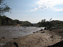
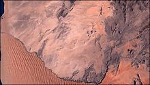
 Natural-colour satellite image of the Kuiseb River.
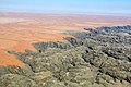 Aerial view of Kuiseb River (2017)
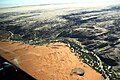 Kuiseb River (2018)
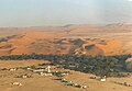 Aerial view of the Gobabeb Training and Research Centre
 Ruins of the Shelter of Korn and Martin
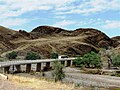 C14 bridge over the Kuiseb Canyon


