 Global Information
Kopua railway station information
Kopua railway station | |||||||||||
|---|---|---|---|---|---|---|---|---|---|---|---|
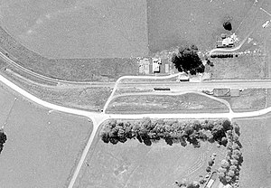 Kopua in 1966 | |||||||||||
| General information | |||||||||||
| Coordinates | 40°05′02″S 176°17′08″E / 40.084023°S 176.285628°E | ||||||||||
| Elevation | 297 m (974 ft) | ||||||||||
| Owned by | KiwiRail | ||||||||||
| Line(s) | Palmerston North–Gisborne Line | ||||||||||
| Distance | Palmerston North 80.44 km (49.98 mi) | ||||||||||
| History | |||||||||||
| Opened | 25 January 1878 | ||||||||||
| Closed | 8 May 1977 | ||||||||||
| Services | |||||||||||
| |||||||||||
Kopua in New Zealand is now a sparsely populated area, immediately south of the border of the Manawatū-Whanganui and Hawke's Bay regions, with 150 people (2018 census) scattered over a 40 km2 (15 sq mi) meshblock.[1] For two years it briefly flourished as a village, centred on a railway station on the Palmerston North–Gisborne line, opened on 25 January 1878,[2] when it became the southern terminus of the line from Napier and Spit. Building to the south was delayed by the need to erect 3 large viaducts over the Manawatū River and its tributaries,[3] so the extension to Makotuku didn't open until 9 August 1880.[4] Kopua then declined until the station closed on 8 May 1977.[2] Only a single line now passes through the station site and there are remnants of cattle yards.[5]
- ^ "2018 Census Individual (part 1) total New Zealand by Statistical Area 1 - GIS". datafinder.stats.govt.nz. Retrieved 13 September 2021.
- ^ a b Names & Opening & Closing Dates of Railway Stations in New Zealand by Juliet Scoble (2012)
- ^ "OPENING OF THE RAILWAY TO TAHORAITE. DAILY TELEGRAPH". paperspast.natlib.govt.nz. 16 December 1884. Retrieved 10 September 2021.
- ^ "Station Archive". NZR Rolling Stock Lists. Archived from the original on 8 February 2013. Retrieved 10 August 2020.
- ^ "742 Takapau-Ormondville Rd". Google Maps. Retrieved 5 September 2021.