Kongsøya, Svenskøya, Abel Island, Helgoland Island, and Tirpitzøya
Area
342 km2 (132 sq mi)
Administration
Norway
Demographics
Population
0
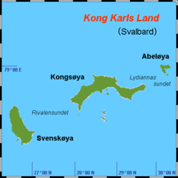
Kong Karls Land or King Charles Land is an island group in the Svalbard archipelago, in the Arctic Ocean. The island group covers an area of 342 km2 (132 sq mi) and is made up of the islands of Kongsøya, Svenskøya, Abel Island, Helgoland Island, and Tirpitzøya.
The islands, which have the largest concentration of polar bear in Svalbard, are part of the Nordaust-Svalbard Nature Reserve, along with Nordaustlandet and Kvitøya. There is a ban on traffic to the islands, which includes the areas of the sea up to 500 metres away from shore and the airspace up to 500 metres above the area.
Kong Karls Land was discovered by an expedition sent by the Muscovy Company in 1617,[1] probably from a high point on Barentsøya. They named the group Wiche Islands, after a member of the company, Richard Wyche.
In the mid-19th century, the islands were rediscovered, and in 1859 the Norwegian Erik Eriksen made the first landing on Svenskøya. In 1870, the Württemberger Theodor von Heuglin named the archipelago King Charles Land after his King Charles I of Württemberg.
^Conway, William Martin (1906). No Man's Land: A History of Spitsbergen from Its Discovery in 1596 to the Beginning of the Scientific Exploration of the Country. Cambridge, At the University Press.
KongKarlsLand or King Charles Land is an island group in the Svalbard archipelago, in the Arctic Ocean. The island group covers an area of 342 km2 (132 sq mi)...
Look up karls in Wiktionary, the free dictionary. Karls may refer to: Surname Karen Karls, American politician Ken Karls (born 1947), Chairman of the North...
Rundisdammen is a lake at Kongsøya in KongKarlsLand, Svalbard. It is located on Rundisflya, west of the glacier Rundisen, at the eastern part of the...
Edgeøya, Barentsøya and KongKarlsLand. It is particularly visible at Edgeøya, Barentsøya and in eastern part of Olav V Land. Triassic outcrops are exposed...
Lernerneset is a headland at the northwestern coast of Abel Island in KongKarlsLand, Svalbard. The headland is named after German Arctic explorer Theodor...
Barentsøya Edgeøya Hopen KongKarlsLand Abel Island Helgoland Island Kongsøya Svenskøya Tirpitzøya Kvitøya Nordaustlandet Prins Karls Forland Spitsbergen...
from Abel Island, both in KongKarlsLand. It is named after the vessel Lydianna, used for exploration of KongKarlsLand in 1872. "Lydiannasundet (Svalbard)"...
separating KongKarlsLand from Nordaustlandet. It is named after skipper and seal hunter Erik Eriksen, who reportedly discovered KongKarlsLand in 1853...
Arnesenodden is a headland on Svenskøya in KongKarlsLand, Svalbard. It is the most northern point of Svenskøya, at the foot of the mountain Mohnhøgda...
Vrakbukta (The Wreck Bay) is a bay at the northwestern side of Kongsøya in KongKarlsLand, Svalbard. It is located between Retziusfjellet and the headland of...
Rundisflya is a plain at the eastern part of Kongsøya in KongKarlsLand, Svalbard. It is located west of the mountain Johnsenberget, and generally has...
Nordaustpynten is a headland at Kongsøya of the KongKarlsLand, Svalbard, the most northeastern point of the island. "Nordaustpynten (Svalbard)". Norwegian...
Nordneset is a headland at the northern side of Kongsøya in KongKarlsLand, Svalbard. It defines the northeastern extension of the bay Bünsowbukta. "Nordneset...
Koppelvatna is the name of five small lakes at Kongsøya in KongKarlsLand, Svalbard. They are located at the eastern part of the island, between Nordaustpynten...
Kennedyneset is a headland at Kongsøya in KongKarlsLand, Svalbard. It is the most western point of the island. The headland is named after Swedish businessperson...
Antarcticbukta is a wide bay at the southern side of Kongsøya in KongKarlsLand, Svalbard. It is located south of the mountain Sjögrenfjellet. The bay...
Svenskebukta is a bay at the northern side of Kongsøya of KongKarlsLand, Svalbard. It is located between Kapp Oscar and eastwards towards a point west...
Bremodden is a headland at the eastern side of Kongsøya in KongKarlsLand, Svalbard. It is located east of Koppelvatna, about 2.5 kilometers south of...
skipper, seal hunter and explorer. He is credited with the discovery of KongKarlsLand and was one of the crew of the 1872 Austro-Hungarian North Pole Expedition...
Kapp Koburg is a headland at the western part of Kongsøya in KongKarlsLand, Svalbard. It is located at the western side of Hårfagrehaugen, and defines...
(The Church Bay) is a bay at the southwestern coast of Svenskøya in KongKarlsLand, Svalbard. Kyrkjevika is partly sheltered by Antarcticøya and other...
 Global Information