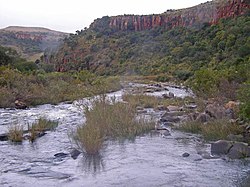
The Komati River,[1] also known as the Inkomati River[2] or Incomati River[3] (in Mozambique, from Portuguese Rio Incomati[4]), is a river in South Africa, Eswatini and Mozambique. Originating in north-western Eswatini, it is joined by the Crocodile River in the Lebombo Mountains, enters far south-western Mozambique below the border town of Komatipoort, and enters the Indian Ocean around 24 km (15 mi) north-east of Maputo.[4]
It is 480 kilometres (298 mi) long, with a drainage basin 50,000 square kilometres (19,300 sq mi) in size. Its mean annual discharge is 111 m3/s (3,920 cfs) at its mouth.[5]
The name Komati is derived from inkomati, meaning "cow" in siSwati, as its perennial nature is compared to a cow that always has milk.[6]
^Nakayama, M. (2003). International Waters in Southern Africa. G - Reference,Information and Interdisciplinary Subjects Series. United Nations University Press. ISBN 978-92-808-1077-6. Retrieved 30 December 2021.
^"Kneria sp nov south africa". Red List of South African Species. South African National Biodiversity Institute (SANBI). Retrieved 30 December 2021.
^Nakayama, M. (2003). International Waters in Southern Africa. G - Reference,Information and Interdisciplinary Subjects Series. United Nations University Press. p. 9,13,14. ISBN 978-92-808-1077-6. Retrieved 30 December 2021.
^ ab"Komati River". Encyclopedia Britannica. 12 December 2014. Retrieved 30 December 2021.
^Nakayama, Mikiyasu (2003). International Waters in Southern Africa. United Nations University Press. p. 9. ISBN 978-92-808-1077-6.[dead link]
^du Plessis, E.J. (1973). Suid-Afrikaanse berg- en riviername. Tafelberg-uitgewers, Cape Town. p. 251. ISBN 0-624-00273-X.
The KomatiRiver, also known as the Inkomati River or Incomati River (in Mozambique, from Portuguese Rio Incomati), is a river in South Africa, Eswatini...
The Sabie River is a river in South Africa that forms part of the KomatiRiver System. The catchment area of the Sabie-Sand system is 6,320 km2 in extent...
Komatipoort is a town situated at the confluence of the Crocodile and KomatiRivers in Mpumalanga province, South Africa. The town is 8 km from the Crocodile...
the KomatiRiver Crocodile River (Minnesota), river in Minnesota This disambiguation page lists articles associated with the title Crocodile River. If...
Komati Power Station, a coal-fired power plant in South Africa KomatiRiver, a River in South Africa, Eswatini and Mozambique Komatiite, a type of ultramafic...
komatiites, an unusual type of ultramafic volcanic rock named after the KomatiRiver that flows through the belt. In April 2014, scientists reported finding...
outposts and royal villages outposts such as Embhuleni, on the upper KomatiRiver at the foot of the Mkhingoma Mountains in Badplaas, Mekemeke near the...
magnesium content. Komatiite was named for its type locality along the KomatiRiver in South Africa, and frequently displays spinifex texture composed of...
The Maguga Dam is a dam on the KomatiRiver in Eswatini. It is 115 metres (377 ft) high and is located about 12 kilometres (7.5 mi) south of Piggs Peak...
city of Nsoko. Others like Mshiza Maseko relocated to farms towards the KomatiRiver in the place called eLuvalweni. The concessions included grants and leases...
komatiites, an unusual type of ultramafic volcanic rock named after the KomatiRiver that flows through the belt. Some of the oldest exposed rocks on Earth...
term for "river" (often tautologically the English term "river" is added to the name). The Zulu word amanzi (water) also forms part of some river names....
Komati Gorge is a river valley in the Mpumalanga Province in central South Africa, which features vertical sandstone cliffs that provide habitat for a...
till the Crocodile River; to the west to Elandspruit till the 26 degrees line; east till where the Crocodile River joins the KomatiRiver." FN states that...
which extends northward from the KomatiRiver at Delagoa Bay in Mozambique's Maputo Province to the Pungwe River in central Mozambique. It was a district...
and Boer forces during the Second Boer War on 7 November 1900, at the KomatiRiver 30 kilometres (19 mi) south of Belfast at the present day Nooitgedacht...
Nooitgedacht Dam is an earth-fill type dam located on the KomatiRiver in South Africa. It was established in 1962 and serves mainly for irrigation purposes...
farms towards the KomatiRiver and Lubombo regions, Mshiza Maseko later settled in a place called eLuvalweni towards Nkomati River, where he was later...
watershed between the westward-flowing Vaal River system and the eastward-flowing Olifants and KomatiRiver systems. The town is located 25 km (15 mi)...
area. In 2001 the 115m high wall of the Maguga Dam was completed in the KomatiRiver 12 km south of town at 25°56′51.41″S 30°4′52.74″E / 25.9476139°S 30...
of rivers in Eswatini. This list is arranged by drainage basin, with respective tributaries indented under each larger stream's name. KomatiRiver (Nkomanzi...
"Long Tom Pass". The first Long Tom was destroyed on the banks of the KomatiRiver near Komatipoort on 22 September 1900.: p. 116 The exact place is not...
 Global Information